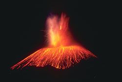
Paricutin 30 612
Autor/Urheber:
Photo credit: K. Segerstrom, U.S. Geological Survey
Shortlink:
Quelle:
Größe:
667 x 1000 Pixel (54224 Bytes)
Beschreibung:
This slide shows the cinder cone soon after its birth in 1943 in a Mexican cornfield. During its brief nine-year lifespan (1943-1952), it built a 410-meter-high cone with extensive lava fields around the base of the cone. Most of the 2 km3 of eruptive products (ash, cinders, and lava) were produced in the first few years. Cinder cones such as this one are commonly formed by one eruption. Each subsequent eruption in the same area forms its own cinder cone.
Kommentar zur Lizenz:
PD-USGov-NOAA
Lizenz:
Public domain
Relevante Bilder


(c) Bundesarchiv, Bild 183-F0316-0204-005 / CC-BY-SA 3.0


(c) Bundesarchiv, Bild 183-C0212-0043-012 / CC-BY-SA 3.0

(c) Bundesarchiv, Bild 183-D0812-0012-002 / CC-BY-SA 3.0


(c) Bundesarchiv, Bild 183-J05235 / Schwahn / CC-BY-SA 3.0

(c) Bundesarchiv, Bild 183-P0613-308 / CC-BY-SA 3.0

(c) RIA Novosti archive, image #602161 / Zelma / CC-BY-SA 3.0


(c) Bundesarchiv, Bild 101I-567-1503C-14 / Toni Schneiders / CC-BY-SA 3.0


Relevante Artikel
ParicutínDer Vulkan Paricutín hat eine Höhe von 2800 Metern und liegt im mexikanischen Bundesstaat Michoacán. Die Stadt Uruapan liegt etwa 20 Kilometer südöstlich des Vulkans. .. weiterlesen
