Nasa satellite photo side by side 2007-10-22
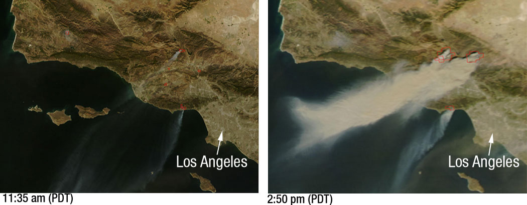
Powerful Santa Ana winds have fueled more than 10 large wildfires throughout Southern California, stretching from Santa Barbara to San Diego.
This pair of images, depicting the area around Los Angeles on October 21, 2007, shows just how quickly the fires grew.
The left image, captured by NASA’s Terra satellite at 11:35 a.m. local time, shows several fires giving off small plumes of smoke. Just over 3 hours later, at 2:50 p.m. when NASA’s Aqua satellite passed overhead, large amounts of smoke were pouring from blazes northwest of Los Angeles. Actively burning fires are outlined in red.
In the right image plumes of smoke can be seen blowing off the coast, indicating the intensity of the winds and the presence of additional fires farther south.
According to the National Interagency Fire Center, these blazes have burned over 84,000 acres since they began over the weekend. Thousands of residents have been evacuated from their homes and a state of emergency has been issued for 7 California counties.


Relevante Bilder


Relevante Artikel
Waldbrände in Südkalifornien 2007Die Waldbrände in Südkalifornien 2007 waren eine Serie von achtzehn Waldbränden in Südkalifornien, die am 20. Oktober bei Malibu im US-Bundesstaat Kalifornien ihren Anfang nahm und 19 Tage andauerte. Insgesamt sind 2800 km² Fläche verbrannt, mehr als 1500 Häuser und zehn Personen wurden Opfer der Flammen, mehr als siebzig Personen wurden verletzt. Die Sachschadenshöhe betrug mehr als eine Milliarde US-Dollar. Im Verlauf entstanden zahlreiche Brandherde. .. weiterlesen