Mweru-Luapula
Autor/Urheber:
NASA credit Jacques Descloitres, MODIS Rapid Response Team, NASA/GSFC; overlay by User:Rexparry_sydney
Shortlink:
Quelle:
Größe:
396 x 949 Pixel (81364 Bytes)
Beschreibung:
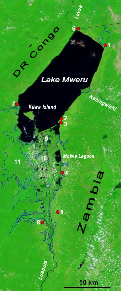
The lower Luapula River, its delta where it enters Lake Mweru, and Mweru's outlet, the Luvua River going on north to the Lualaba and Congo rivers. Water shows up as black in this false-colour NASA satellite image. The extent of the Luapula Swamps is shown by the solid blue line, and the extent of the floodplain is shown as a dotted line. The towns are, in Zambia: 1 Chiengi, 2 Kashikishi, 3 Nchelenge, 4 Mwansabombwe, 5 Mwense; in DR Congo: 6 Pweto, 7 Kilwa, 8 Kasenga. Other features: 9 Chisenga Island, 10 the largest swamp island (in DR Congo), 11 the main floodplain.
Kommentar zur Lizenz:
NASA public domain and my permission for overlay to also be Public Domain.
Lizenz:
Public domain
Credit:
Image NASA Visible Earth website, overlay in Word
Bild teilen:


Relevante Bilder


Relevante Artikel
KalungwishiDer Kalungwishi ist ein Fluss in Sambia. Er gehört zum Flusssystem des Kongo. .. weiterlesen
Kilwa (Insel)Kilwa ist eine Insel im Mwerusee in der Provinz Luapula in Sambia und liegt etwa sieben Kilometer vor der Stadt Kilwa am Seeufer der Demokratischen Republik Kongo. Die Grenze verläuft zwischen der Insel Kilwa und der Stadt Kilwa. Auf der Insel leben etwa 20.000 Menschen. .. weiterlesen