Mediterranean heatwave ESA23380840

Autor/Urheber:
European Space Agency
Shortlink:
Quelle:
Größe:
1920 x 1920 Pixel (2491991 Bytes)
Beschreibung:
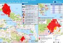
Scorching temperatures hit both Greece and Turkey this week, leading to the temporary closure of the Acropolis – Greece’s most visited monument.
This map shows the land surface temperature of Greece and surrounding countries on 30 June. The data show that surface temperatures reached over 50°C in many locations including the northwest of Athens and many regions in Turkey. The blue spots visible near Albania are clouds.
The map has been generated using the Copernicus Sentinel-3’s Sea and Land Surface Temperature Radiometer. Whereas weather forecasts use predicted air temperatures, the satellite measures the real amount of energy radiating from Earth – therefore this map better represents the real temperature of the land surface.
Lizenz:
Attribution
Credit:
Bild teilen:


Relevante Bilder

.jpeg)


Relevante Artikel
Hitzewelle und Waldbrände in Südeuropa und der Türkei 2021Die Hitzewelle und Waldbrände in Südeuropa und der Türkei 2021 begannen in der ersten Juliwoche 2021 in Südeuropa. Ursache der besonders großen Hitze war der Scirocco. Die Hitzewelle wird als Folge des Klimawandels diskutiert. .. weiterlesen