Maratona dles Dolomites - Dolomites
Autor/Urheber:
Maratona dles Dolomites Committee Photographer
Attribution:
Das Bild ist mit 'Attribution Required' markiert, aber es wurden keine Informationen über die Attribution bereitgestellt. Vermutlich wurde bei Verwendung des MediaWiki-Templates für die CC-BY Lizenzen der Parameter für die Attribution weggelassen. Autoren und Urheber finden für die korrekte Verwendung der Templates hier ein Beispiel.
Shortlink:
Quelle:
Größe:
1600 x 1067 Pixel (769318 Bytes)
Beschreibung:
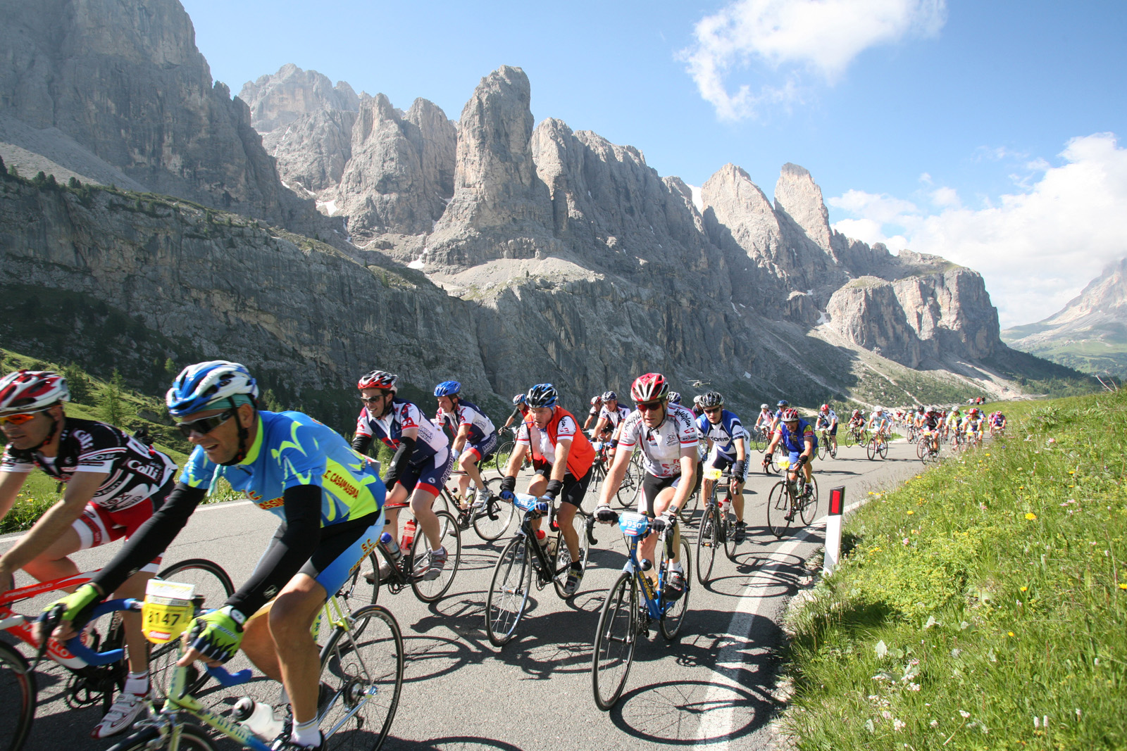
Dolomiten-Marathon 2008. Aufnahme von der Westzufahrt zum Grödner Joch. Im Hintergrund in der Mitte die Murfreitspitze, rechts die beiden Murfreittürme, ganz rechts der Einschnitt des Sellajochs, daneben am Bildrand der Langkofel in den Dolomiten.
Kommentar zur Lizenz:
Lizenz:
Credit:
Maratona dles Dolomites Committee
Relevante Bilder
![](https://upload.wikimedia.org/wikipedia/commons/thumb/a/a5/02_2020_Grecia_photo_Paolo_Villa_FO199964_%28Ancona_Patrasso_traghetto_-_veduta_sulla_costa_albanese_greca_-_view_on_the_Albanian_Greek_coast%29.jpg/250px-02_2020_Grecia_photo_Paolo_Villa_FO199964_%28Ancona_Patrasso_traghetto_-_veduta_sulla_costa_albanese_greca_-_view_on_the_Albanian_Greek_coast%29.jpg)
![](https://upload.wikimedia.org/wikipedia/commons/thumb/b/b8/The_tiny_hamlet_named%2C_Brand_visible_down_in_the_shade_and_the_Otztal_with_nice_mountains_behind_-_panoramio.jpg/250px-The_tiny_hamlet_named%2C_Brand_visible_down_in_the_shade_and_the_Otztal_with_nice_mountains_behind_-_panoramio.jpg)
(c) Henk Monster, CC BY 3.0
![](https://upload.wikimedia.org/wikipedia/commons/thumb/a/a9/Umhausen_-_Ortseinfahrt_nach_Umhausen-Dorf_mit_Blick_auf_die_Pfarrkirche_hl_Vitus.jpg/125px-Umhausen_-_Ortseinfahrt_nach_Umhausen-Dorf_mit_Blick_auf_die_Pfarrkirche_hl_Vitus.jpg)
![](https://upload.wikimedia.org/wikipedia/commons/thumb/4/43/ETH-BIB-Sicht_auf_die_Österreichischen_Zentralalpen_bei_der_Besteigung_des_Grossglockners-Weitere-LBS_MH02-18-0034.tif/lossy-page1-125px-ETH-BIB-Sicht_auf_die_Österreichischen_Zentralalpen_bei_der_Besteigung_des_Grossglockners-Weitere-LBS_MH02-18-0034.tif.jpg)
![](https://upload.wikimedia.org/wikipedia/commons/thumb/7/74/Gezicht_op_berglandschap_gezien_vanuit_een_bosrijke_omgeving%2C_Oostenrijk_October_1906_%28titel_op_object%29%2C_RP-F-2007-15-165.jpg/250px-Gezicht_op_berglandschap_gezien_vanuit_een_bosrijke_omgeving%2C_Oostenrijk_October_1906_%28titel_op_object%29%2C_RP-F-2007-15-165.jpg)
![](https://upload.wikimedia.org/wikipedia/commons/thumb/5/5a/Base_del_Gran_Pilastro_%28BZ%29_-_dove_il_ghiaccio_diventa_cristallo_-_panoramio.jpg/250px-Base_del_Gran_Pilastro_%28BZ%29_-_dove_il_ghiaccio_diventa_cristallo_-_panoramio.jpg)
(c) giovanni bidi, CC BY 3.0
![](https://upload.wikimedia.org/wikipedia/commons/thumb/7/7f/Naters_railway_station%2C_Valais%2C_Switzerland.jpg/250px-Naters_railway_station%2C_Valais%2C_Switzerland.jpg)
![](https://upload.wikimedia.org/wikipedia/commons/thumb/e/ec/Mittelalterlicher_Brunnen%2C_Filialkirche_hl._Athanasius%2C_Berg_im_Drautal%2C_Kärnten.jpg/250px-Mittelalterlicher_Brunnen%2C_Filialkirche_hl._Athanasius%2C_Berg_im_Drautal%2C_Kärnten.jpg)
![](https://upload.wikimedia.org/wikipedia/commons/thumb/1/17/Cesta_v_korunách_stromů%2C_výhled_z_rozhledny_-_Neuschönau%2C_Německo_-_panoramio.jpg/250px-Cesta_v_korunách_stromů%2C_výhled_z_rozhledny_-_Neuschönau%2C_Německo_-_panoramio.jpg)
(c) Pavel Špindler, CC BY 3.0
![](https://upload.wikimedia.org/wikipedia/commons/thumb/9/95/ETH-BIB-Flug_Wien_-_Zürich_über_Grossglockner_-_Oetztal_-_Silvretta_-_Walensee-Weitere-LBS_MH02-10-0015.tif/lossy-page1-125px-ETH-BIB-Flug_Wien_-_Zürich_über_Grossglockner_-_Oetztal_-_Silvretta_-_Walensee-Weitere-LBS_MH02-10-0015.tif.jpg)
![](https://upload.wikimedia.org/wikipedia/commons/thumb/4/48/ETH-BIB-Flug_Wien_-_Zürich_über_Grossglockner_-_Oetztal_-_Silvretta_-_Walensee-Weitere-LBS_MH02-10-0010.tif/lossy-page1-125px-ETH-BIB-Flug_Wien_-_Zürich_über_Grossglockner_-_Oetztal_-_Silvretta_-_Walensee-Weitere-LBS_MH02-10-0010.tif.jpg)
![](https://upload.wikimedia.org/wikipedia/commons/thumb/1/13/Der_"Adler"_von_Sellrain_Tirol_%28Position_liegt_genau_auf_dem_Auge_des_Adlers%29_-_panoramio.jpg/250px-Der_"Adler"_von_Sellrain_Tirol_%28Position_liegt_genau_auf_dem_Auge_des_Adlers%29_-_panoramio.jpg)
(c) Florian Brenner, CC BY 3.0
![](https://upload.wikimedia.org/wikipedia/commons/thumb/6/6b/A_part_of_Reit_im_Winkl_-_view_Reit_im_Winkl_-_panoramio_%281%29.jpg/400px-A_part_of_Reit_im_Winkl_-_view_Reit_im_Winkl_-_panoramio_%281%29.jpg)
(c) King Otto, CC BY-SA 3.0
![](https://upload.wikimedia.org/wikipedia/commons/thumb/8/86/ETH-BIB-Teil_der_Alpen_zwischen_der_Schweiz%2C_Österreich_und_Italien-Weitere-LBS_MH02-32-0025.tif/lossy-page1-125px-ETH-BIB-Teil_der_Alpen_zwischen_der_Schweiz%2C_Österreich_und_Italien-Weitere-LBS_MH02-32-0025.tif.jpg)
![](https://upload.wikimedia.org/wikipedia/commons/thumb/a/a7/ETH-BIB-Teil_der_Alpen_zwischen_der_Schweiz%2C_Österreich_und_Italien-Weitere-LBS_MH02-32-0022.tif/lossy-page1-125px-ETH-BIB-Teil_der_Alpen_zwischen_der_Schweiz%2C_Österreich_und_Italien-Weitere-LBS_MH02-32-0022.tif.jpg)
![](https://upload.wikimedia.org/wikipedia/commons/thumb/d/df/Il_ghiacciaio_del_Tribulaun_-_3097_m_%28BZ%29_visto_dalla_Silvermoos_-_panoramio.jpg/250px-Il_ghiacciaio_del_Tribulaun_-_3097_m_%28BZ%29_visto_dalla_Silvermoos_-_panoramio.jpg)
(c) giovanni bidi, CC BY 3.0
![](https://upload.wikimedia.org/wikipedia/commons/thumb/6/6b/An_overview_of_Imja_Tsho_showing_lake_outlet_channel%2C_ponds%2C_ablation_valley.jpg/250px-An_overview_of_Imja_Tsho_showing_lake_outlet_channel%2C_ponds%2C_ablation_valley.jpg)
![](https://upload.wikimedia.org/wikipedia/commons/thumb/5/5d/1435_mm_rail_gauge_excursion_4874.jpg/250px-1435_mm_rail_gauge_excursion_4874.jpg)
![](https://upload.wikimedia.org/wikipedia/commons/thumb/5/59/Fotothek_df_ps_0002084_Landschaften_^_Hügellandschaften_-_Gebirgslandschaften_^.jpg/250px-Fotothek_df_ps_0002084_Landschaften_^_Hügellandschaften_-_Gebirgslandschaften_^.jpg)
(c) Deutsche Fotothek, CC BY-SA 3.0 de
![](https://upload.wikimedia.org/wikipedia/commons/thumb/0/03/Fotothek_df_ps_0001808_Bäume_^_Landschaften_^_Hügellandschaften_-_Gebirgslandsch.jpg/125px-Fotothek_df_ps_0001808_Bäume_^_Landschaften_^_Hügellandschaften_-_Gebirgslandsch.jpg)
(c) Deutsche Fotothek, CC BY-SA 3.0 de
![](https://upload.wikimedia.org/wikipedia/commons/thumb/b/b0/Fotothek_df_ps_0002080_Landschaften_^_Hügellandschaften_-_Gebirgslandschaften_^.jpg/125px-Fotothek_df_ps_0002080_Landschaften_^_Hügellandschaften_-_Gebirgslandschaften_^.jpg)
(c) Deutsche Fotothek, CC BY-SA 3.0 de
![](https://upload.wikimedia.org/wikipedia/commons/thumb/a/a0/Fotothek_df_ps_0001965_Landschaften_^_Hügellandschaften_-_Gebirgslandschaften.jpg/125px-Fotothek_df_ps_0001965_Landschaften_^_Hügellandschaften_-_Gebirgslandschaften.jpg)
(c) Deutsche Fotothek, CC BY-SA 3.0 de
![](https://upload.wikimedia.org/wikipedia/commons/thumb/0/02/Fotothek_df_ps_0002077_Landschaften_^_Hügellandschaften_-_Gebirgslandschaften_^.jpg/125px-Fotothek_df_ps_0002077_Landschaften_^_Hügellandschaften_-_Gebirgslandschaften_^.jpg)
(c) Deutsche Fotothek, CC BY-SA 3.0 de
![](https://upload.wikimedia.org/wikipedia/commons/thumb/a/a1/Fotothek_df_ps_0000982_Landschaften_^_Hügellandschaften_-_Gebirgslandschaften.jpg/250px-Fotothek_df_ps_0000982_Landschaften_^_Hügellandschaften_-_Gebirgslandschaften.jpg)
(c) Deutsche Fotothek, CC BY-SA 3.0 de
![](https://upload.wikimedia.org/wikipedia/commons/thumb/7/7c/Fotothek_df_ps_0002081_Landschaften_^_Hügellandschaften_-_Gebirgslandschaften_^.jpg/125px-Fotothek_df_ps_0002081_Landschaften_^_Hügellandschaften_-_Gebirgslandschaften_^.jpg)
(c) Deutsche Fotothek, CC BY-SA 3.0 de
![](https://upload.wikimedia.org/wikipedia/commons/thumb/d/d2/Fotothek_df_ps_0005192_Landschaften_^_Hügellandschaften_-_Gebirgslandschaften.jpg/250px-Fotothek_df_ps_0005192_Landschaften_^_Hügellandschaften_-_Gebirgslandschaften.jpg)
(c) Deutsche Fotothek, CC BY-SA 3.0 de
![](https://upload.wikimedia.org/wikipedia/commons/thumb/5/5e/Prinz-Luitpold-Haus%2C_am_Anfang_des_Aufstieg_zum_Hochvogel_-_panoramio.jpg/250px-Prinz-Luitpold-Haus%2C_am_Anfang_des_Aufstieg_zum_Hochvogel_-_panoramio.jpg)
(c) Clemens Pohl, CC BY-SA 3.0
![](https://upload.wikimedia.org/wikipedia/commons/thumb/d/d1/Fotothek_df_ps_0001967_Landschaften_^_Hügellandschaften_-_Gebirgslandschaften_^.jpg/125px-Fotothek_df_ps_0001967_Landschaften_^_Hügellandschaften_-_Gebirgslandschaften_^.jpg)
(c) Deutsche Fotothek, CC BY-SA 3.0 de
![](https://upload.wikimedia.org/wikipedia/commons/thumb/9/9c/Fotothek_df_ps_0001789_Bäume_^_Landschaften_^_Hügellandschaften_-_Gebirgslandsch.jpg/125px-Fotothek_df_ps_0001789_Bäume_^_Landschaften_^_Hügellandschaften_-_Gebirgslandsch.jpg)
(c) Deutsche Fotothek, CC BY-SA 3.0 de
![](https://upload.wikimedia.org/wikipedia/commons/thumb/e/eb/Imst_-_Kapuzinerkloster_und_Kirche_hl_Josef_-_Ansicht_von_Osten_-_II.jpg/250px-Imst_-_Kapuzinerkloster_und_Kirche_hl_Josef_-_Ansicht_von_Osten_-_II.jpg)
![](https://upload.wikimedia.org/wikipedia/commons/thumb/e/e4/Fotothek_df_ps_0001790_Bäume_^_Landschaften_^_Hügellandschaften_-_Gebirgslandsch.jpg/125px-Fotothek_df_ps_0001790_Bäume_^_Landschaften_^_Hügellandschaften_-_Gebirgslandsch.jpg)
(c) Deutsche Fotothek, CC BY-SA 3.0 de
![](https://upload.wikimedia.org/wikipedia/commons/thumb/f/f1/Kappl%2C_katholische_Pfarrkirche_heilige_Antonius_Dm64356_foto5_2014-0723_15.56.jpg/250px-Kappl%2C_katholische_Pfarrkirche_heilige_Antonius_Dm64356_foto5_2014-0723_15.56.jpg)
![](https://upload.wikimedia.org/wikipedia/commons/thumb/1/1d/Fotothek_df_ps_0001792_Bäume_^_Landschaften_^_Hügellandschaften_-_Gebirgslandsch.jpg/250px-Fotothek_df_ps_0001792_Bäume_^_Landschaften_^_Hügellandschaften_-_Gebirgslandsch.jpg)
(c) Deutsche Fotothek, CC BY-SA 3.0 de
![](https://upload.wikimedia.org/wikipedia/commons/thumb/f/f4/Fotothek_df_ps_0002075_Landschaften_^_Hügellandschaften_-_Gebirgslandschaften_^.jpg/125px-Fotothek_df_ps_0002075_Landschaften_^_Hügellandschaften_-_Gebirgslandschaften_^.jpg)
(c) Deutsche Fotothek, CC BY-SA 3.0 de
![](https://upload.wikimedia.org/wikipedia/commons/thumb/2/2d/Fotothek_df_ps_0004089_Landschaften_^_Hügellandschaften_-_Gebirgslandschaften.jpg/125px-Fotothek_df_ps_0004089_Landschaften_^_Hügellandschaften_-_Gebirgslandschaften.jpg)
(c) Deutsche Fotothek, CC BY-SA 3.0 de
![](https://upload.wikimedia.org/wikipedia/commons/thumb/c/c8/Fotothek_df_ps_0001968_Landschaften_^_Hügellandschaften_-_Gebirgslandschaften_^.jpg/125px-Fotothek_df_ps_0001968_Landschaften_^_Hügellandschaften_-_Gebirgslandschaften_^.jpg)
(c) Deutsche Fotothek, CC BY-SA 3.0 de
![](https://upload.wikimedia.org/wikipedia/commons/thumb/5/53/Heiterwang%2C_katholische_Pfarrkirche_Unsere_Liebe_Frau_Mariae_Himmelfahrt_Dm64074_foto11_2014-07-25_10.13.jpg/250px-Heiterwang%2C_katholische_Pfarrkirche_Unsere_Liebe_Frau_Mariae_Himmelfahrt_Dm64074_foto11_2014-07-25_10.13.jpg)
![](https://upload.wikimedia.org/wikipedia/commons/thumb/4/48/Grossglockner_Hochalpenstrasse%2C_panoráma_észak_felé._Fortepan_57276.jpg/250px-Grossglockner_Hochalpenstrasse%2C_panoráma_észak_felé._Fortepan_57276.jpg)
(c) FOTO:FORTEPAN / Karabélyos Péter, CC BY-SA 3.0
![](https://upload.wikimedia.org/wikipedia/commons/thumb/0/0e/38030_Varena%2C_Province_of_Trento%2C_Italy_-_panoramio_%281%29.jpg/250px-38030_Varena%2C_Province_of_Trento%2C_Italy_-_panoramio_%281%29.jpg)
(c) Maurizio Ceol, CC BY 3.0
![](https://upload.wikimedia.org/wikipedia/commons/thumb/b/b8/Fotothek_df_ps_0000981_Landschaften_^_Hügellandschaften_-_Gebirgslandschaften.jpg/250px-Fotothek_df_ps_0000981_Landschaften_^_Hügellandschaften_-_Gebirgslandschaften.jpg)
(c) Deutsche Fotothek, CC BY-SA 3.0 de
![](https://upload.wikimedia.org/wikipedia/commons/thumb/7/7d/Fotothek_df_ps_0001913_Landschaften_^_Hügellandschaften_-_Gebirgslandschaften_^.jpg/125px-Fotothek_df_ps_0001913_Landschaften_^_Hügellandschaften_-_Gebirgslandschaften_^.jpg)
(c) Deutsche Fotothek, CC BY-SA 3.0 de