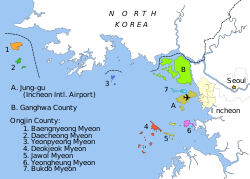
Map of Korean maritime border
(c) Amble, 玖巧仔 and Tomchen1989, CC BY-SA 3.0
Autor/Urheber:
See above
Shortlink:
Quelle:
Größe:
912 x 653 Pixel (354027 Bytes)
Beschreibung:
Karte der Seegrenze zwischen Nord- und Südkorea, sprachneutrale Version.
- Yeonpyeong
- Baengnyeong
- Daecheong Myeon
- Jung-gu (Internationaler Flughafen Incheon)
- Seoul
- Incheon
- Haeju
- Kaesong
- Ganghwa County
- Bukdo Myeon
- Deokjeok Myeon
- Jawol Myeon
- Yeongheung Myeon
- A. Northern Limit Line (NLL, seit 1953 von Südkorea beanspruchte Grenze)
- B. Demilitarisierte Zone (Seit 1999 von Nordkorea geforderte Grenze)
Lizenz:
Credit:
Based on File:Inchon islands 2.svg (by Amble) and File:朝韩争议区(延坪岛附近).svg (by 玖巧仔). Modified and converted to language neutral version by Tomchen1989. Flags are from File:Flag of South Korea.svg and File:Flag of North Korea.svg which are in the public domain. The Northern Limit Line and the Military Demarcation Line are according to Xinhua and NYTimes; compare Jon M. Van Dyke, Mark J. Valencia, Jenny Miller Garmendia. "The North/South Korea Boundary Dispute in the Yellow (West) Sea," . Marine Policy 27 (2003), 143-158, 144; excerpt, "Fig. 1. North/South Korea Maritime Border Area in the Yellow (West) Sea (Sources: Map of Maritime Boundaries compiled by Beckee Morrison based on North Korean MDL declaration as reported in "Koreas' North rejects maritime border with South in West Sea," Central Broadcasting Station, September 2, 1999; South Korean Defense Department reconstruction in Chosun Daily News, July 7, 2002; Ministry of National Defense, The Republic of Korea Position Regarding the Northern Limit Line, August 2002; "North Korea issues communiqué on navigation around Yellow Sea islands," Central Broadcasting Station, March 23, 2000."
Relevante Bilder
Relevante Artikel
Northern Limit LineDie Northern Limit Line (deutsch: Nördliche Grenzlinie) oder auch North Limit Line (NLL) ist eine umstrittene maritime Demarkationslinie im Gelben Meer vor der Westküste der koreanischen Halbinsel. Ihre Länge beträgt ca. 200 Kilometer; sie ist etwa vier Kilometer breit. Die Northern Limit Line wurde 1953 eingerichtet und wird international als De-facto-Seegrenze zwischen Nordkorea und Südkorea angesehen. .. weiterlesen


