Map of Huron Country, 1631–51
Autor/Urheber:
Brébeuf, Jean de, saint, 1593-1649
Shortlink:
Quelle:
Größe:
1236 x 1024 Pixel (2122296 Bytes)
Beschreibung:
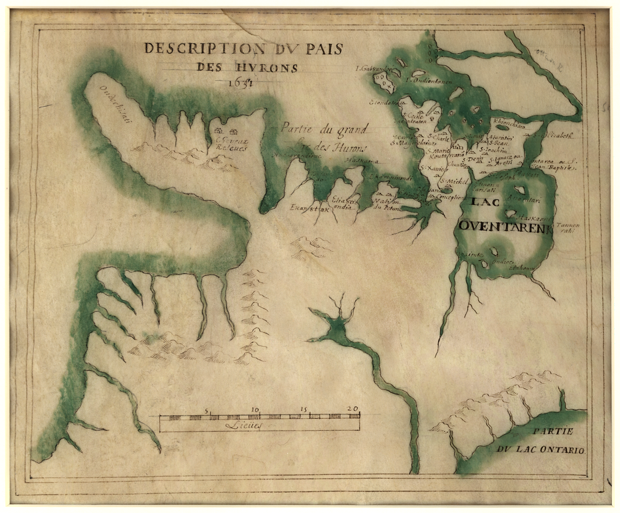
This important manuscript map on vellum depicts part of present-day Ontario, Canada, extending from Georgian Bay in the north (Partie du Grand Lac des Hurons) to Lake Ontario in the south, and from Lake Huron in the west to Lake Simcoe in the east (Lac Oventarenk). The map originally was dated 1631, but the date later was changed to 1651. Canadian scholar Conrad E. Heidenreich concluded that the main part of the map probably was drawn between 1639 and 1648, with slight revisions made after 1650, which most likely explains the change from 1631 to 1651. Heidenreich also surmised that the map, which is unsigned, was drawn by Saint Jean de Brébeuf (1593–1649). The map evidently was made to illustrate the location of Indian tribes and Jesuit missions, particularly in the area between Lake Simcoe and Georgian Bay. Brébeuf was born in Normandy, France, and joined the Jesuit order in 1617. In 1626 he established the first mission among the Huron Indians. He was captured by the Iroquois, enemies of the Hurons, then tortured and burned to death on March 16, 1649. He was canonized in 1930.
Georgian Bay (Ontario : Bay); Great Lakes Region (North America); Huron, Lake (Michigan and Ontario); Jesuits; Ontario, Lake (New York and Ontario); Simcoe, Lake (Ontario); Wyandot Indians
Georgian Bay (Ontario : Bay); Great Lakes Region (North America); Huron, Lake (Michigan and Ontario); Jesuits; Ontario, Lake (New York and Ontario); Simcoe, Lake (Ontario); Wyandot Indians
Lizenz:
Public domain
Credit:
Bild teilen:


Relevante Bilder
.png)

(c) I, Padraic Ryan, CC BY-SA 3.0
Relevante Artikel
ChonnontonDie Bezeichnung „Chonnonton“ geht auf Samuel de Champlain (1567–1635) zurück, der wohl eine nicht mehr identifizierbare indigene Gruppe im südlichen Ontario auf einer Karte als „e qui chonnonton“ bezeichnete. Damit meinte er wohl eine Gruppe, die Rotwild hielt, wobei Tierhaltung, sieht man von Hunden ab, bei den Indianern Nordamerikas sonst nicht vorkommt. Als „People of the deer“, wie es bedeutungsgleich im Englischen heißt, wurden ansonsten nur die Mowachaht an der Pazifikküste Kanadas bezeichnet. .. weiterlesen