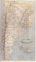
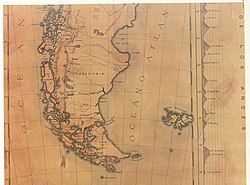
Map of Argentina by Francisco Latzina, 1882
The first official argentine map, produced, after the Boundary Treaty of 1881. It was ordered to be drawn up by the then Argentine Minister of the Interior, Bernardo de Irigoyen for inclusion in an official publication issued by the Director of the National Statistics Office in 1883 under the title "The Argentine Republic as a field for European Emigration". This was published in Spanish, English, German, French and Italian in a edition of 120,000 copies.
See [1]. The Latzina map of 1882 proved to be significant in the ICJ case between Argentina and Chile over the disputed Beagle Channel islands, since the disputed islands are shown as Chilean territory. It was created under the auspices of Señor Irigoyen, who had been previously responsible for negotiating the Boundary Treaty of 1881 with Chile. Due to his involvement, the significance of showing the islands as Chilean was deemed by the ICJ as a direct representation of Irigoyen's view of the boundaries between the two countries.
Relevante Bilder
Relevante Artikel
Beagle-Kartographie ab 1881Die Zone des Beagle-Kanals, entdeckt in den 30er Jahren des 19. Jahrhunderts, war eine der Letzten, die von Chilenen und Argentiniern besiedelt wurde. Das raue und kalte Klima, die weite Entfernung zu anderen Städten, die fehlenden Ressourcen und die Schwierigkeiten beim Transport hemmten die Besiedlung dieser Region. .. weiterlesen


