MARS-Viking

Autor/Urheber:
NASA/JPL/USGS
Shortlink:
Quelle:
Größe:
6787 x 6787 Pixel (3638446 Bytes)
Beschreibung:
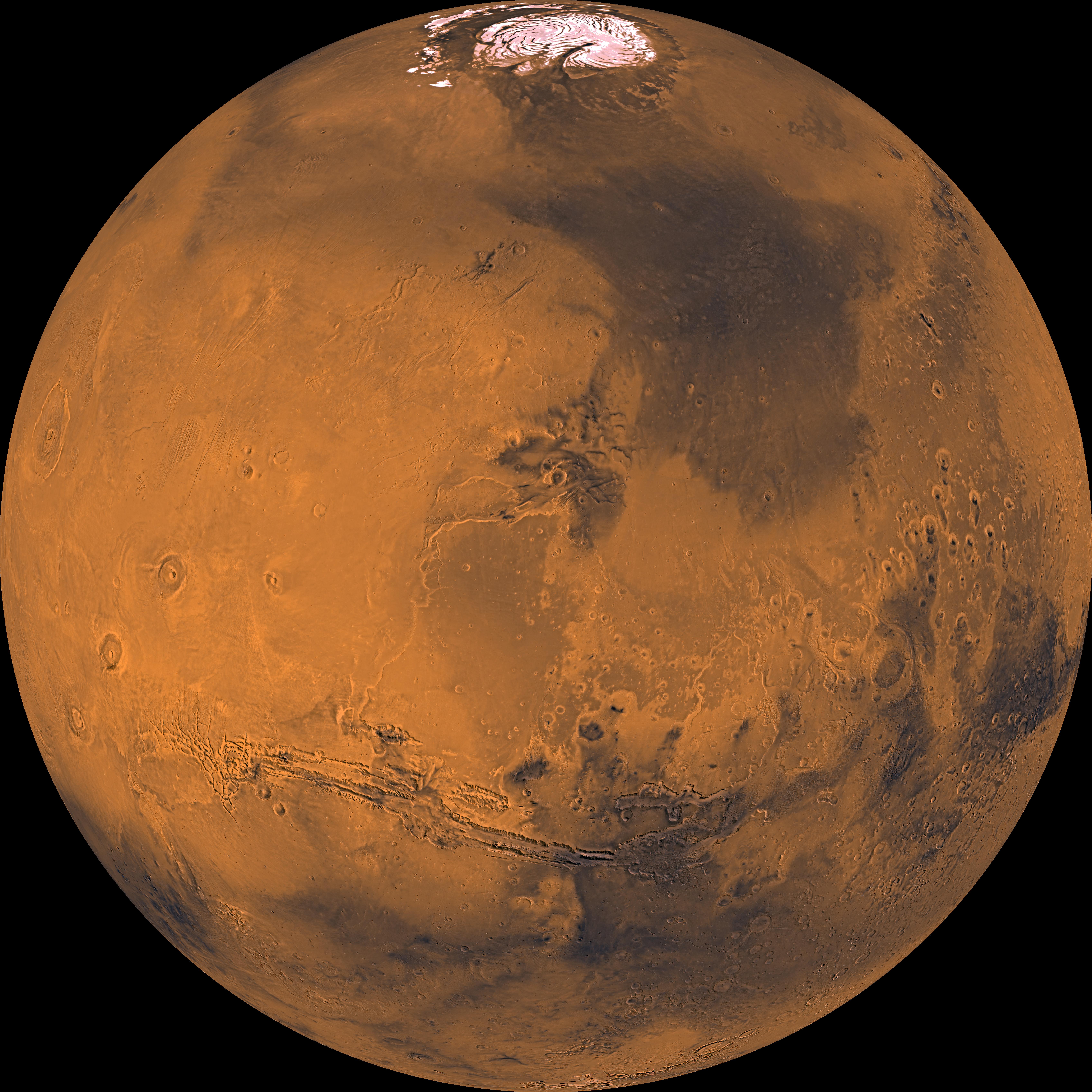
About 1000 Viking Orbiter red- and violet-filter images have been processed to provide global color coverage of Mars at a scale of 1 km/pixel. Individual image frames acquired during a single spacecraft revolution were first processed through radiometric calibration, cosmetic cleanup, geometric control, reprojection, and mosaicing. We have produced a total of 57 "single-rev" mosaics. All of the mosaics are geometrically tied to the Mars Digital Image Mosaic, a black-and-white base map with a scale of 231 m/pixel. We selected a subset of single-rev mosaics that provide the best global coverage (least atmospheric obscuration and seasonal frost); photometric normalization was applied to remove atmospheric effects and normalize the variations in illumination and viewing angles. Finally, these normalized mosaics were combined into global mosaics. Global coverage is about 98% complete in the red-filter mosaic and 95% complete in the violet-filter mosaic. Gaps were filled by interpolation. A green-filter image was synthesized from an average of the red and violet filter data to complete a 3-color set. The Viking Orbiters acquired actual green-filter images for only about half of the Martian surface. The final mosaic has been reprojected into several map projections. The orthographic view shown here is centered at 20 degrees latitude and 60 degrees longitude. The orthographic view is most like the view seen by a distant observer looking through a telescope. The color balance selected for these images was designed to be close to natural color for the bright reddish regions such as Tharsis and Arabia, but the data have been "stretched" such that the relatively dark regions appear darker and less reddish that their natural appearance. This stretching allows us to better see the color and brightness variations on Mars, which are related to the composition or physical structure of the surface materials, which include volcanic lava flows, wind- and water-deposited sedimentary rocks, and (at the poles) ice caps. The north polar cap is visible in this projection at the top of the image, the great equatorial canyon system (Valles Marineris) below center, and four huge Tharsis volcanoes (and several smaller ones) at left. Also note heavy impact cratering of the highlands (bottom and right portions of this mosaic) and the younger, less heavily cratered terrains elsewhere.
Lizenz:
Public domain
Bild teilen:


Relevante Bilder


Relevante Artikel
Space: 1889Space: 1889 ist ein Steampunk-Rollenspiel von Frank Chadwick aus dem Jahr 1988. Der Name ist eine Anspielung auf die Fernsehserie Space: 1999. Ursprünglicher Hersteller von Space: 1889 ist die inzwischen aufgelöste Firma Games Designers Workshop (GDW). Seit 2000 wird Space: 1889 von Heliograph Incorporated herausgegeben. Seit 2012 erscheint eine deutschsprachige Ausgabe im Uhrwerk Verlag. 2019 erwarb Ulisses North America die Rechte an Space 1889. In der Folge wurde bekannt, dass der Uhrwerk-Verlag nicht länger über die Lizenz verfügt. .. weiterlesen