Kashmir map
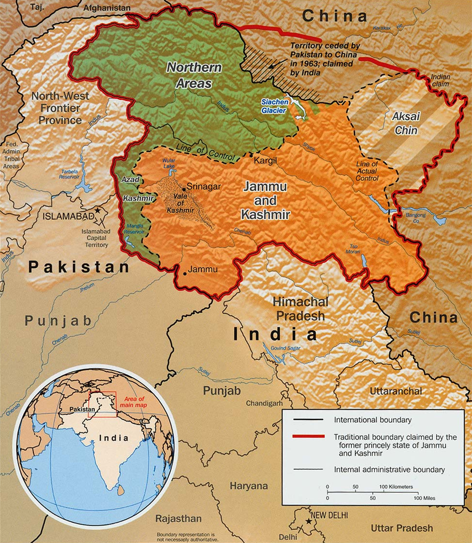
Original text from CIA World Factbook: "The Disputed Territory : Shown in green is Kashmiri region under Pakistani control. The dark-brown region represents Indian-controlled Jammu and Kashmir while the Aksai Chin is under Chinese occupation."
Library of Congress, Geography and Map Division, Washington, D.C. 20540-4650 USA. Info from its archive page [1] for this map:
Kashmir region.
United States. Central Intelligence Agency.
CREATED/PUBLISHED [Washington : Central Intelligence Agency, 2003]
NOTES "763537AI (R00744) 5-03."
Relief shown by shading.
Shows boundaries and disputed areas.
Includes location map.
Scale [ca. 1:510,000].
SUBJECTS
- Jammu and Kashmir (India)--Maps
- Jammu and Kashmir (India)--Boundaries--Maps.
- India--Jammu and Kashmir.
MEDIUM 1 map : col. ; 20 x 17 cm.
CALL NUMBER G7653.J3 2003 .U51
REPOSITORY Library of Congress Geography and Map Division Washington, D.C. 20540-4650 USA
DIGITAL ID
g7653j ct001059 http://hdl.loc.gov/loc.gmd/g7653j.ct001059


Relevante Bilder


Relevante Artikel
Liste von TerritorialstreitigkeitenDies ist eine Liste von bis heute andauernden Territorialstreitigkeiten, also sich entgegenstehender Gebietsansprüche zwischen Staaten oder anderen Gebieten.Anmerkung zur Liste: Fettdruck bedeutet die vollständige Herrschaft, kursiv gesetzt partielle Herrschaft. .. weiterlesen
Line of ControlDie Line of Control (LoC) ist eine Demarkationslinie, die den faktischen Grenzverlauf zwischen zwei militärisch oder polizeilich kontrollierten Territorien markiert. .. weiterlesen