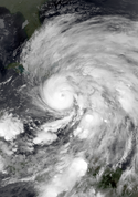
Isaac 2012-08-28 1630Z
The Moderate Resolution Imaging Spectroradiometer (MODIS) on NASA’s Terra satellite captured this image of Isaac in the Gulf of Mexico at 11:30 a.m. Central Daylight Time (16:30 Universal Time) on August 28, 2012. Researchers working with the Suomi-NPP satellite also captured this nighttime view of the storm from earlier today. At 1 p.m. CDT on August 28, forecasters at the National Hurricane Center (NHC) reported that Isaac was centered at 28.4° North latitude and 88.7° West longitude, about 135 miles (220 kilometers) south of New Orleans. The storm was moving northwestward toward the mouth of the Mississippi River at 10 miles (17 kilometers) per hour, with maximum sustained winds of 75 miles (120 kilometers) per hour. Hurricane-force winds extended 60 miles (96 kilometers) from the center. NHC forecasters expected Isaac to strengthen a bit before reaching shore, and warned of potential flooding from rainfall of 7 to 14 inches (18 to 36 centimeters), with localized precipitation up to 20 inches (50 centimeters). They also warned of a storm surge that could reach 6 to 12 feet (2 to 3.5 meters), depending on the timing of landfall and of local tides. Though just a category 1 storm, Isaac’s slow forward motion had the potential to pile up more water in the storm surge. Winds and storm surges are worst on the right/northeastern side of hurricanes. The five-day forecast suggested that the hurricane and its remnants would head straight up the Mississippi River basin and perhaps to the Ohio River—potentially offering some relief in areas where the river has been exceptionally low. But the heavy rains could also provoke severe flooding, as the parched ground and dried up crops will not necessarily absorb that much water.
NASA is just days from launching an intensive multi-year study of hurricane formation and evolution in the Atlantic Ocean. Known as the Hurricane and Severe Storm Sentinel (HS3) mission, the project will use robotic Global Hawk airplanes to fly over and through storm systems. A principal goal is to learn more about what makes tropical storms intensify into hurricanes.Relevante Bilder
Relevante Artikel
Atlantische Hurrikansaison 2012Die Atlantische Hurrikansaison 2012 beginnt offiziell am 1. Juni und endet am 30. November. Während dieser Periode bilden sich üblicherweise die meisten Hurrikane, da nur zu dieser Zeit geeignete Bedingungen existieren, wie etwa ein warmer Ozean, feuchte Luft und wenig Windscherung, um die Bildung von tropischen Wirbelstürmen zu ermöglichen. Die Saison 2012 startete jedoch vorzeitig mit der Bildung des tropischen Sturms Alberto am 19. Mai. Auch der zweite benannte Sturm der Saison, Beryl, entstand vor dem offiziellen Saisonbeginn am 26. Mai. Es war das erste Mal seit der atlantischen Hurrikansaison 1951, dass sich vor dem offiziellen Saisonbeginn zwei Stürme bildeten. Stürme im Pazifischen Ozean sind im Artikel Pazifische Hurrikansaison 2012 gelistet. .. weiterlesen
Hurrikan Isaac (2012)Hurrikan Isaac war der neunte benannte tropische Wirbelsturm der Atlantischen Hurrikansaison 2012. Das Kapverdensystem entwickelte sich in der zweiten Augusthälfte, zog über die nördlichen Inseln über dem Winde hinweg, streifte Puerto Rico und erreichte den Süden von Hispaniola als starker tropischer Sturm. Dieser zog über die Tiburon-Halbinsel und den Golf von Gonâve hinweg in west-nordwestlicher Richtung zur Ostspitze Kubas. Der Sturm verbrachte nur kurze Zeit über der bergigen Region des Inselstaates und folgte dann dessen Nordküste weiter nach Nordwesten. Nach der Passage durch die Floridastraße nahm Isaac Kurs auf die westlichen Florida Keys. Nach einer Verlagerung seines Zentrums nach Westen setzte Isaac seine Wanderung nach Nordwesten durch den östlichen Golf von Mexiko fort. Am Nachmittag des 28. August erreichte Isaac in Richtung New Orleans ziehend den Status eines Hurrikans. Sich langsam vorwärtsbewegend zog Isaac im Südosten von Louisiana über Land und allmählich nordwärts entlang des Mississippi River. Am 29. August wurde Isaac zum tropischen Sturm zurückgestuft und am 30. August zum tropischen Tiefdruckgebiet. Seine tropischen Eigenschaften verlor das System am 1. September über Missouri. .. weiterlesen


