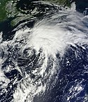
Irene Aug 24 2011 1810Z
The Moderate Resolution Imaging Spectroradiometer (MODIS) on NASA’s Aqua satellite captured this natural-color image at 2:15 p.m. local time (18:15 UTC) on August 24. Storm clouds hide the Turks and Caicos Islands, and extend westward over The Bahamas. Clouds also linger over the Dominican Republic and Haiti. At 2:00 p.m. Eastern Daylight Time on August 24, about the time MODIS took this picture, the U.S. National Hurricane Center (NHC) reported that Irene was a Category 3 hurricane with maximum sustained winds of 120 miles (195 kilometers) per hour. By 5:00 a.m. EDT on August 25, the NHC reported, Irene’s winds had weakened slightly, to 115 miles (185 kilometers) per hour. The storm remained a powerful Category 3 hurricane. A hurricane warning was in effect for the southeastern, central, and northwestern Bahamas. A hurricane watch was in effect for Surf City, North Carolina, northward to the Virginia border. A tropical storm watch was in effect for Edisto Beach, South Carolina, north to Surf City. As of 5:00 a.m. EDT on August 25, Irene was moving toward the northwest at about 12 miles (19 kilometers) per hour. The storm was expected to turn toward the north-northwest the same day, then toward the north early the following day. The NHC five-day storm track showed Irene moving northward along the U.S. East Coast.
As U.S. residents braced for Irene’s arrival, residents of Caribbean Islands cleaned up from the destructive storm. The Christian Science Monitor reported that flooding and mudslides had forced the Dominican Republic to evacuate nearly 38,000 people, and a U.S.-based analysis firm estimated potential damage in the Caribbean at up to $3.1 billion.Relevante Bilder
Relevante Artikel
Hurrikan Irene (2011)Hurrikan Irene war ein tropischer Wirbelsturm, der Auswirkungen auf Puerto Rico, die Dominikanische Republik, Haiti, die Turks- und Caicosinseln und die Bahamas hatte und anschließend an der Ostküste der Vereinigten Staaten Richtung Norden zog. Irene war der neunte tropische Sturm und erste Hurrikan der atlantischen Hurrikansaison 2011. Er entstand am 20. August 2011 östlich der Kleinen Antillen und zog dann über die Leeward Islands hinweg, bevor er eine nordwestlichere und später nordwärts gerichtete Zugbahn einschlug. Der Hurrikan traf in der Kategorie 1 in North Carolina auf das Festland der Vereinigten Staaten, gelangte südlich der Chesapeake Bay erneut über Wasser und schlug eine nord-nordöstliche Zugrichtung ein, die ihn die Küste New Jerseys streifen ließ. Er hatte ein ungewöhnlich großes Windfeld, sodass die Auswirkungen des Hurrikans durch Windbruch, Sturmflut und Starkregen weitreichender waren als bei tropischen Wirbelstürmen vergleichbarer Intensität. .. weiterlesen
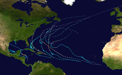
Atlantische Hurrikansaison 2011Die Atlantische Hurrikansaison 2011 begann offiziell am 1. Juni und endete am 30. November. Während dieser Periode bilden sich die meisten tropischen Stürme, da nur zu dieser Zeit geeignete Bedingungen, wie etwa ein warmer Ozean, feuchte Luft und wenig Windscherung, existieren, um die Bildung von Tropischen Wirbelstürmen zu ermöglichen. .. weiterlesen


