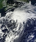
Hurricane Philippe Oct 6 2011 1445Z
As of 11:00 a.m. Atlantic Standard Time (AST) on October 6, Philippe packed winds of 80 miles (130 kilometers) per hour, and was about 425 miles (680 kilometers) southeast of Bermuda, the NHC reported. At 10:45 a.m. the same day, the Moderate Resolution Imaging Spectroradiometer (MODIS) on NASA’s Terra satellite took this picture. The spiral-shaped storm spans hundreds of kilometers north to south.
The NHC forecast that Philippe would weaken somewhat over the next 48 hours and travel toward the northeast.Relevante Bilder
Relevante Artikel
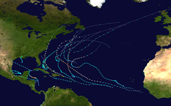
Atlantische Hurrikansaison 2011Die Atlantische Hurrikansaison 2011 begann offiziell am 1. Juni und endete am 30. November. Während dieser Periode bilden sich die meisten tropischen Stürme, da nur zu dieser Zeit geeignete Bedingungen, wie etwa ein warmer Ozean, feuchte Luft und wenig Windscherung, existieren, um die Bildung von Tropischen Wirbelstürmen zu ermöglichen. .. weiterlesen


