Holt, St Martin's, nave 6149662
(c) Michael Garlick, CC BY-SA 2.0
Autor/Urheber:
Shortlink:
Quelle:
Größe:
7150 x 4766 Pixel (8140500 Bytes)
Beschreibung:
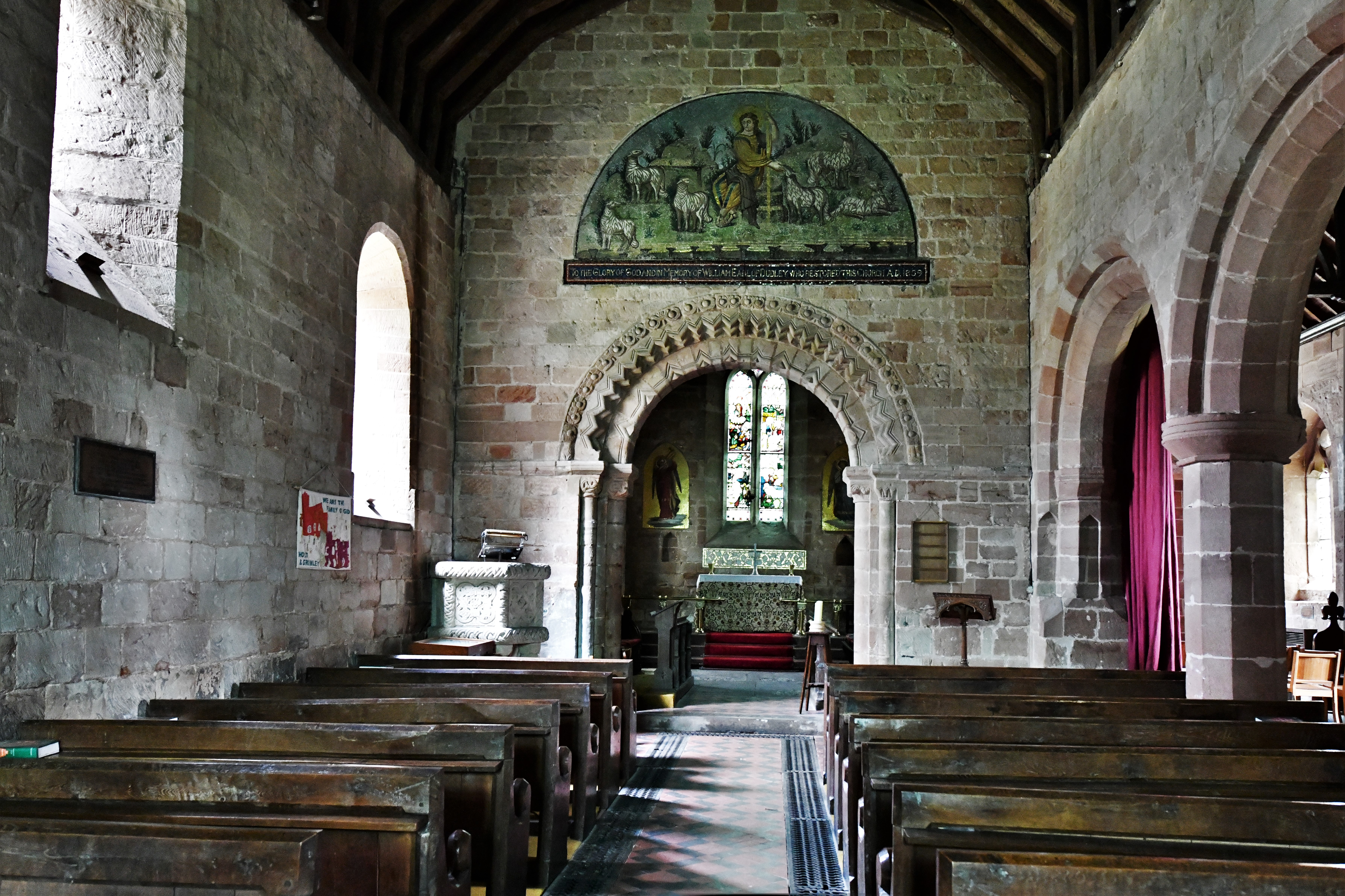
Holt, St. Martin's Church: The Norman nave
Kommentar zur Lizenz:
Creative Commons Attribution Share-alike license 2.0
Lizenz:
Credit:
From geograph.org.uk
Relevante Bilder
![](https://upload.wikimedia.org/wikipedia/commons/thumb/e/e5/Holt%2C_St_Martin%27s_from_SE_6149633.jpg/250px-Holt%2C_St_Martin%27s_from_SE_6149633.jpg)
(c) Michael Garlick, CC BY-SA 2.0
![](https://upload.wikimedia.org/wikipedia/commons/thumb/7/76/Sampford_Courtenay%2C_St_Andrews_Church-_The_barrel_vault_in_the_nave_%28geograph_4951626%29.jpg/250px-Sampford_Courtenay%2C_St_Andrews_Church-_The_barrel_vault_in_the_nave_%28geograph_4951626%29.jpg)
(c) Michael Garlick, CC BY-SA 2.0
![](https://upload.wikimedia.org/wikipedia/commons/thumb/3/3d/Long_Benton_St_Bartholomew_south_face_GeoUK_6779082.jpg/250px-Long_Benton_St_Bartholomew_south_face_GeoUK_6779082.jpg)
(c) Geoff Holland, CC BY-SA 2.0
![](https://upload.wikimedia.org/wikipedia/commons/thumb/a/a3/West_Worlington_St_Mary_nave_eastward_GeoUK_6406193.jpg/250px-West_Worlington_St_Mary_nave_eastward_GeoUK_6406193.jpg)
(c) Roger Cornfoot, CC BY-SA 2.0
![](https://upload.wikimedia.org/wikipedia/commons/thumb/7/7a/Torpenhow%2C_St._Michael%27s_Church-_The_nave_from_the_chancel_%28geograph_6234321%29.jpg/250px-Torpenhow%2C_St._Michael%27s_Church-_The_nave_from_the_chancel_%28geograph_6234321%29.jpg)
(c) Michael Garlick, CC BY-SA 2.0
![](https://upload.wikimedia.org/wikipedia/commons/thumb/f/fb/Salcombe_Regis%2C_St_Mary_%26_St_Peter_west_face_GeoUK_6297853.jpg/125px-Salcombe_Regis%2C_St_Mary_%26_St_Peter_west_face_GeoUK_6297853.jpg)
(c) John P Reeves, CC BY-SA 2.0
![](https://upload.wikimedia.org/wikipedia/commons/thumb/e/e5/Plymstock_St_Mary_%26_All_Saints_nave_%2B_aisles_eastward_GeoUK_7531043.jpg/250px-Plymstock_St_Mary_%26_All_Saints_nave_%2B_aisles_eastward_GeoUK_7531043.jpg)
(c) Alan Murray-Rust, CC BY-SA 2.0
![](https://upload.wikimedia.org/wikipedia/commons/thumb/8/83/Bristol_St_Michael_o_t_Mount_nave_roof_skeleton_GeoUK_6277237.jpg/125px-Bristol_St_Michael_o_t_Mount_nave_roof_skeleton_GeoUK_6277237.jpg)
(c) Neil Owen, CC BY-SA 2.0
![](https://upload.wikimedia.org/wikipedia/commons/thumb/f/fb/Westley_Waterless_St_Mary_nave_%26_south_aisle_GeoUK_6021185.jpg/250px-Westley_Waterless_St_Mary_nave_%26_south_aisle_GeoUK_6021185.jpg)
(c) Michael Garlick, CC BY-SA 2.0
![](https://upload.wikimedia.org/wikipedia/commons/thumb/5/55/Alne%2C_St_Mary_the_Virgin%2C_fr_east%2C_GeoUK_5663114.jpg/250px-Alne%2C_St_Mary_the_Virgin%2C_fr_east%2C_GeoUK_5663114.jpg)
(c) John Salmon, CC BY-SA 2.0
![](https://upload.wikimedia.org/wikipedia/commons/thumb/4/42/Pillerton_Hersey_St_Mary_Vi_tower_%2B_north_aisle_fr_W_GeoUK_1782593.jpg/125px-Pillerton_Hersey_St_Mary_Vi_tower_%2B_north_aisle_fr_W_GeoUK_1782593.jpg)
(c) David P Howard, CC BY-SA 2.0
![](https://upload.wikimedia.org/wikipedia/commons/thumb/3/37/Upottery_St_Mary_Virgin_fr_W_GeoUK_7036642.jpg/250px-Upottery_St_Mary_Virgin_fr_W_GeoUK_7036642.jpg)
(c) Rob Purvis, CC BY-SA 2.0
![](https://upload.wikimedia.org/wikipedia/commons/thumb/8/82/Ducklington_St_Bartholomew_north-eastward_GeoUK_5612547.jpg/250px-Ducklington_St_Bartholomew_north-eastward_GeoUK_5612547.jpg)
(c) Chris Brown, CC BY-SA 2.0
![](https://upload.wikimedia.org/wikipedia/commons/thumb/6/68/Interior%2C_St_Andrew%27s_church%2C_Radbourne_%28geograph_4044616%29.jpg/250px-Interior%2C_St_Andrew%27s_church%2C_Radbourne_%28geograph_4044616%29.jpg)
(c) J.Hannan-Briggs, CC BY-SA 2.0
![](https://upload.wikimedia.org/wikipedia/commons/thumb/1/18/Bristol_St_Michael_o_t_Mount_south_aisle_westward_GeoUK6277264.jpg/125px-Bristol_St_Michael_o_t_Mount_south_aisle_westward_GeoUK6277264.jpg)
(c) Neil Owen, CC BY-SA 2.0
![](https://upload.wikimedia.org/wikipedia/commons/thumb/1/19/Stoke_Talmage_St_Mary_Magdalene_north_face_GeoUK_5734917.jpg/250px-Stoke_Talmage_St_Mary_Magdalene_north_face_GeoUK_5734917.jpg)
(c) Bill Nicholls, CC BY-SA 2.0
![](https://upload.wikimedia.org/wikipedia/commons/thumb/5/5d/Heanton_Punchardon_St_Augustine_south_face_GeoUK_5952776.jpg/250px-Heanton_Punchardon_St_Augustine_south_face_GeoUK_5952776.jpg)
(c) Roger Cornfoot, CC BY-SA 2.0
![](https://upload.wikimedia.org/wikipedia/commons/thumb/1/1a/Leominster_Priory_south_aisle_%26_south_nave_GeoUK_5696106.jpg/250px-Leominster_Priory_south_aisle_%26_south_nave_GeoUK_5696106.jpg)
(c) Fabian Musto, CC BY-SA 2.0
![](https://upload.wikimedia.org/wikipedia/commons/thumb/a/a2/Filleigh_St_Paul_crossing_%2B_chancel_GeoUK_6287857.jpg/125px-Filleigh_St_Paul_crossing_%2B_chancel_GeoUK_6287857.jpg)
(c) Roger Cornfoot, CC BY-SA 2.0
![](https://upload.wikimedia.org/wikipedia/commons/thumb/3/33/Stoke_Rivers_St_Bartholomew_eastward_GeoUK_6152537.jpg/250px-Stoke_Rivers_St_Bartholomew_eastward_GeoUK_6152537.jpg)
(c) Roger Cornfoot, CC BY-SA 2.0
![](https://upload.wikimedia.org/wikipedia/commons/thumb/f/f4/Wigginton_St_Leonard_west_face_GeoUK_6572080.jpg/250px-Wigginton_St_Leonard_west_face_GeoUK_6572080.jpg)
(c) Basher Eyre, CC BY-SA 2.0
![](https://upload.wikimedia.org/wikipedia/commons/thumb/0/08/Skelmanthorpe_St_Aidan_nave_%26_north_aisle_eastward_GeoUK_7364358.jpg/250px-Skelmanthorpe_St_Aidan_nave_%26_north_aisle_eastward_GeoUK_7364358.jpg)
(c) Diocese of Leeds, CC BY-SA 2.0
![](https://upload.wikimedia.org/wikipedia/commons/thumb/1/15/Pillerton_Hersey_St_Mary_Vi_from_SSE_GeoUK_1782609.jpg/250px-Pillerton_Hersey_St_Mary_Vi_from_SSE_GeoUK_1782609.jpg)
(c) David P Howard, CC BY-SA 2.0
![](https://upload.wikimedia.org/wikipedia/commons/thumb/2/20/Appleton_St_Lawrence_arcade_GeoUK_6920664.jpg/250px-Appleton_St_Lawrence_arcade_GeoUK_6920664.jpg)
(c) Basher Eyre, CC BY-SA 2.0
![](https://upload.wikimedia.org/wikipedia/commons/thumb/b/bf/Plymstock_St_Mary_%26_All_Saints_fr_W_GeoUK_7531038.jpg/125px-Plymstock_St_Mary_%26_All_Saints_fr_W_GeoUK_7531038.jpg)
(c) Alan Murray-Rust, CC BY-SA 2.0
![](https://upload.wikimedia.org/wikipedia/commons/thumb/1/1d/Hayes_%28Hillingdon%29_St_Mary_northeastward_GeoUK1686356.jpg/250px-Hayes_%28Hillingdon%29_St_Mary_northeastward_GeoUK1686356.jpg)
(c) John Salmon, CC BY-SA 2.0
![](https://upload.wikimedia.org/wikipedia/commons/thumb/1/15/Woodston_St_Augustine_from_S_GeoUK_7140793.jpg/250px-Woodston_St_Augustine_from_S_GeoUK_7140793.jpg)
(c) Dave Kelly, CC BY-SA 2.0
![](https://upload.wikimedia.org/wikipedia/commons/thumb/8/89/Plymstock_St_Mary_%26_All_Saints_S_aisle_to_NE_GeoUK_7531040.jpg/250px-Plymstock_St_Mary_%26_All_Saints_S_aisle_to_NE_GeoUK_7531040.jpg)
(c) Alan Murray-Rust, CC BY-SA 2.0
![](https://upload.wikimedia.org/wikipedia/commons/thumb/9/98/Halford_St_Mary_eastward_GeoUK_5314392.jpg/250px-Halford_St_Mary_eastward_GeoUK_5314392.jpg)
(c) Philip Halling, CC BY-SA 2.0
![](https://upload.wikimedia.org/wikipedia/commons/thumb/7/78/Interior%2C_St_Mary_and_All_Saints_church%2C_Swarby_%28geograph_2924983%29.jpg/250px-Interior%2C_St_Mary_and_All_Saints_church%2C_Swarby_%28geograph_2924983%29.jpg)
(c) J.Hannan-Briggs, CC BY-SA 2.0
![](https://upload.wikimedia.org/wikipedia/commons/thumb/5/54/Alne_St_Mary_east_end_GeoUK_5663118.jpg/250px-Alne_St_Mary_east_end_GeoUK_5663118.jpg)
(c) John Salmon, CC BY-SA 2.0
![](https://upload.wikimedia.org/wikipedia/commons/thumb/3/3a/Brightwell_Baldwin_St_Bartholomew_north_face_GeoUK_5501455.jpg/250px-Brightwell_Baldwin_St_Bartholomew_north_face_GeoUK_5501455.jpg)
(c) Bill Nicholls, CC BY-SA 2.0
![](https://upload.wikimedia.org/wikipedia/commons/thumb/d/d4/Scalby_St_Laurence_west_end_GeoUK6211706.jpg/250px-Scalby_St_Laurence_west_end_GeoUK6211706.jpg)
(c) Ian S, CC BY-SA 2.0
![](https://upload.wikimedia.org/wikipedia/commons/thumb/2/24/Wigginton_St_Leonard_nave_looking_SW_GeoUK_6574555.jpg/250px-Wigginton_St_Leonard_nave_looking_SW_GeoUK_6574555.jpg)
(c) Basher Eyre, CC BY-SA 2.0
![](https://upload.wikimedia.org/wikipedia/commons/thumb/c/c9/Gunwalloe_St_Winwaloe_south_aisle_eastward_GeoUK_5600904.jpg/250px-Gunwalloe_St_Winwaloe_south_aisle_eastward_GeoUK_5600904.jpg)
(c) Derek Voller, CC BY-SA 2.0
![](https://upload.wikimedia.org/wikipedia/commons/thumb/a/ab/Stoodleigh_St_Margaret_eastward_GeoUK_5580481.jpg/250px-Stoodleigh_St_Margaret_eastward_GeoUK_5580481.jpg)
(c) Roger Cornfoot, CC BY-SA 2.0
![](https://upload.wikimedia.org/wikipedia/commons/thumb/9/9f/West_Anstey_St_Petrock_nave_%26_tower_from_SE_GeoUK_5920627.jpg/125px-West_Anstey_St_Petrock_nave_%26_tower_from_SE_GeoUK_5920627.jpg)
(c) Roger Cornfoot, CC BY-SA 2.0
![](https://upload.wikimedia.org/wikipedia/commons/thumb/1/13/Huntshaw_St_Mary_Magdalene_eastward_GeoUK_7327296.jpg/250px-Huntshaw_St_Mary_Magdalene_eastward_GeoUK_7327296.jpg)
(c) Roger Cornfoot, CC BY-SA 2.0
![](https://upload.wikimedia.org/wikipedia/commons/thumb/5/5f/Kemerton%2C_St_Nicholas_nave_%2B_aisles_GeoUK_5844726.jpg/250px-Kemerton%2C_St_Nicholas_nave_%2B_aisles_GeoUK_5844726.jpg)
(c) Philip Pankhurst, CC BY-SA 2.0
![](https://upload.wikimedia.org/wikipedia/commons/thumb/3/3f/St_Mary_in_the_Marsh_St_Mary_westward_GeoUK_6941218.jpg/250px-St_Mary_in_the_Marsh_St_Mary_westward_GeoUK_6941218.jpg)
(c) Michael Garlick, CC BY-SA 2.0
![](https://upload.wikimedia.org/wikipedia/commons/thumb/b/bd/Winkleigh_All_Saints_rood_screen%2C_chancel_GeoUK_6996413.jpg/250px-Winkleigh_All_Saints_rood_screen%2C_chancel_GeoUK_6996413.jpg)
(c) John H Darch, CC BY-SA 2.0
![](https://upload.wikimedia.org/wikipedia/commons/thumb/e/e8/Lea%2C_Lincs%2C_St_Helen_aisle_%26_nave_eastward_GeoUK_5392175.jpg/250px-Lea%2C_Lincs%2C_St_Helen_aisle_%26_nave_eastward_GeoUK_5392175.jpg)
(c) Julian P Guffogg, CC BY-SA 2.0
Relevante Artikel
Liste der Hallenkirchen im Vereinigten Königreich▶ Liste(n) der Hallenkirchen – Übersicht .. weiterlesen