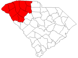
Greenville-Spartanburg-Anderson CSA
Shortlink:
Quelle:
Größe:
541 x 437 Pixel (18439 Bytes)
Beschreibung:
Locator map of the Greenville-Spartanburg-Anderson, SC CSA in the northwestern part of the U.S. state of South Carolina. The Six components of the CSA are colored separately:
- Red: Greenville-Anderson MSA
- Blue: Spartanburg MSA
- Yellow: Seneca μSA
- Light Green: Greenwood μSA
- Light Purple: Gaffney μSA
- Light Blue Union μSA
Kommentar zur Lizenz:
The original modification by Nyttend is released into public domain. I hereby release my modification into public domain too.
Lizenz:
Public domain
Relevante Bilder
Relevante Artikel
Upstate South CarolinaDie Metropolregion Upstate South Carolina ist eine Metropolregion im US-Bundesstaate South Carolina. Sie stellt eine durch das Office of Management and Budget definierte Combined Statistical Area (CSA) dar und wird von der Behörde offiziell als Greenville–Spartanburg–Anderson, SC Combined Statistical Area bezeichnet. .. weiterlesen


