Geomap Zentralnamibia
Autor/Urheber:
Attribution:
Das Bild ist mit 'Attribution Required' markiert, aber es wurden keine Informationen über die Attribution bereitgestellt. Vermutlich wurde bei Verwendung des MediaWiki-Templates für die CC-BY Lizenzen der Parameter für die Attribution weggelassen. Autoren und Urheber finden für die korrekte Verwendung der Templates hier ein Beispiel.
Shortlink:
Quelle:
Größe:
1890 x 2799 Pixel (3575271 Bytes)
Beschreibung:
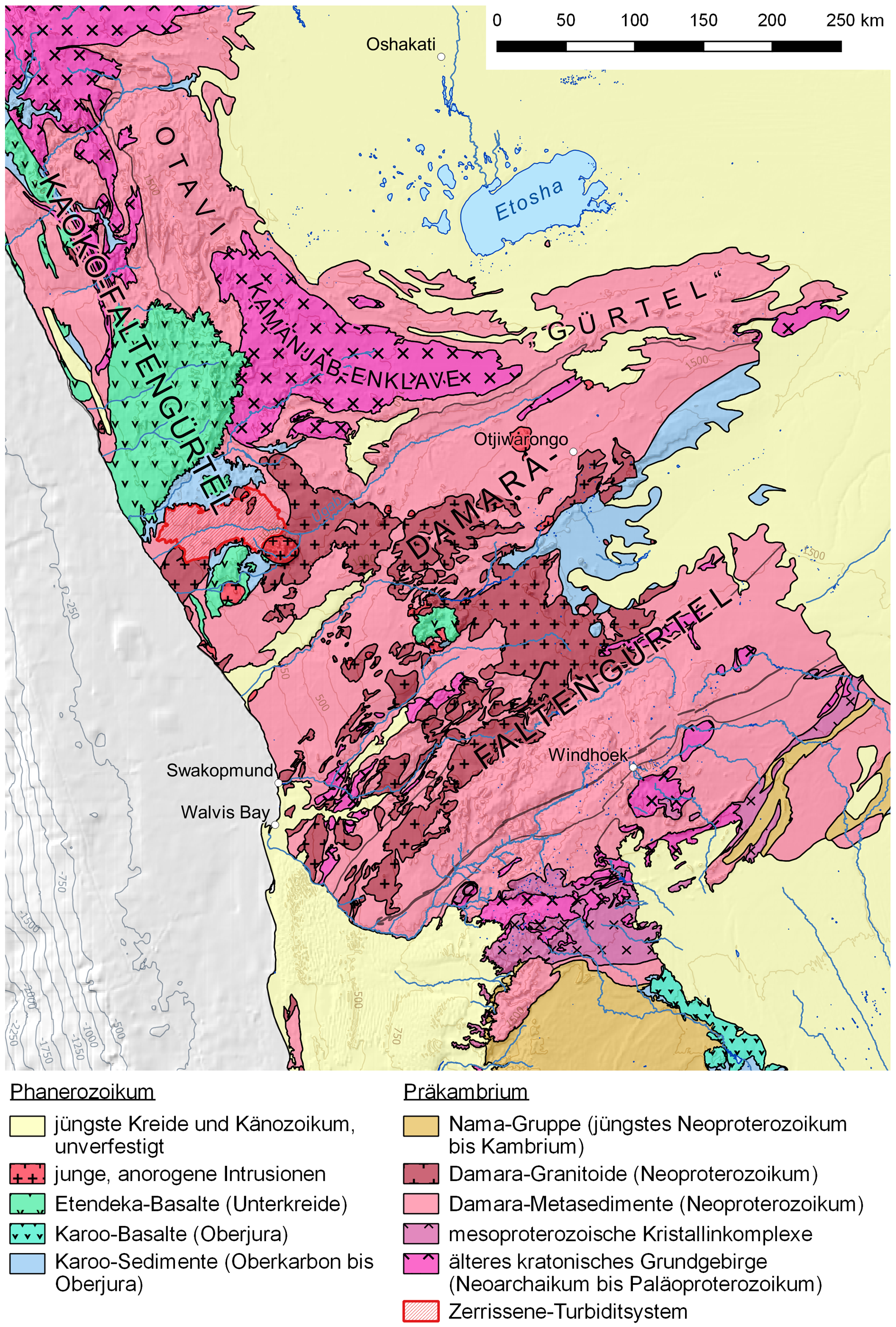
Karte der Oberflächengeologie des zentralen Teils Namibias mit Kennzeichnung der Lage des Zerrissene Turbidite Systems
Lizenz:
Credit:
Eigenes Werk
- Mainly created with QGIS, finalized with Adobe Illustrator and Photoshop
- Geological spatial data (shape file) are from Digital Atlas of Namibia: Geology which, in turn, credits Atlas of Namibia Project (2002), Directorate of Environmental Affairs, Ministry of Environment and Tourism (cited link http://209.88.21.36/Atlas/Atlas_web.htm is broken)
- colours and symbols by Gretarsson
- Digital Elevation Model for creating the hillshade background layer and contour lines: SRTM 30 arc second tile GeoTIFFs, downloaded at NOAA’s National Centers for Environmental Information
- Rivers, lakes, places and borders: Open Street Map data (created by Open Street Map contributors, 2017, distributed under the Open Data Commons Open Database License), downloaded as shapefiles at Geofabrik
- Shape of outcrop of the Zerrissene Turbidite System digitized from Landsat 7 images (false color, band combination 7-5-4), downloaded at USGS Earth Explorer, and according to Passchier et al. (2002)[1]
- Labels are according to Passchier et al. (2002)[1], Gray et al. (2008)[2], and Wallace et al. (2014)[3]
- ↑ a b C. W. Passchier, R. A. J. Trouw, A. Ribeiro, F. V. P. Paciullo (2002): Tectonic evolution of the southern Kaoko belt, Namibia. Journal of African Earth Sciences 35(1):61–75, doi:10.1016/S0899-5362(02)00030-1
- ↑ D. R. Gray, D. A. Foster, J. G. Meert, B. D. Goscombe, R. Armstrong, R. A. J. Trouw, C. W. Passchier: A Damara orogen perspective on the assembly of southwestern Gondwana. Geological Society, London, Special Publications 294:257–278, doi:10.1144/SP294.14, fig. 3
- ↑ Malcolm W. Wallace, Ashleigh v.S. Hood, Estee M.S. Woon, Karl-Heinz Hoffmann, Christopher P. Reed: Enigmatic chambered structures in Cryogenian reefs: The oldest sponge-grade organisms? Precambrian Research 255(1):109–123, doi:10.1016/j.precamres.2014.09.020, fig. 1
Bild teilen:


Relevante Bilder


.jpg)


Relevante Artikel
Zerrissene Turbidite SystemDas Zerrissene Turbidite System ist eine mehrphasig gefaltete, niedriggradig metamorphe Sequenz überwiegend siliziklastischer turbiditischer Ablagerungsgesteine im Nordwesten Namibias. Seine sedimentäre und tektonische Entwicklung umfasst einen Zeitraum von vor 750 bis 530 Millionen Jahren. .. weiterlesen