G-F triangulation
Autor/Urheber:
Shortlink:
Quelle:
Größe:
272 x 400 Pixel (21941 Bytes)
Beschreibung:
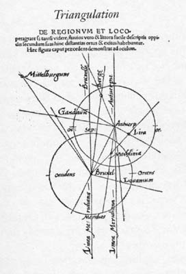
Gemma Frisius's 1533 diagram introducing the idea of triangulation into the science of surveying. Having established a baseline, eg the cities of Brussels and Antwerp, the location of other cities, eg Middelburg, can be found by taking its compass direction at each end of the baseline, and plotting where the two directions cross. Note that this was only a theoretical presentation of the concept -- because of hills etc, it is in fact actually impossible to see Middelburg from either Brussels or Antwerp! Nevertheless, the figure soon became well known all across Europe.
Lizenz:
Public domain
Credit:
Libellus de locorum describendorum ratione. This scan found at [1]
![[1]](http://www.math.yorku.ca/SCS/Gallery/images/G-F_triangulation.jpg)
Bild teilen:


Relevante Bilder


Relevante Artikel
Gemma R. FrisiusGemma Rainer Frisius, eigentlich Jemme Reinersz, war ein Mediziner, Astronom, Mathematiker, Kartograf und Instrumentenbauer. Frisius schuf Globen und verbesserte mathematische und astronomische Instrumente, etwa das Astrolabium und den Gradstock. Er wandte die Mathematik bei der Vermessung und Navigation in einer neuen Art an, entwickelte Vorstufen der Triangulation und publizierte 1544 über die Verwendung der Camera Obscura bei der Beobachtung der Sonnenfinsternis vom 24. Januar 1544. .. weiterlesen