Ferris Mountain Wilderness Study Area (9314432213)
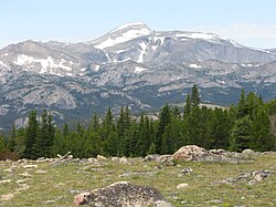
The Ferris Mountains WSA encompasses 22,245 acres (9,002 ha) of BLM-administered land and one private inholding of 160 acres. The study area is steep and rugged, providing unusual and spectacular scenery. Ferris Peak is the highest point in the Great Divide Basin at 10,037 feet (3,059 m) and rises some 3,000 feet (910 m) from the valley floor. Large stands of Douglas fir, interspersed with grassy parks create an alpine setting.
Known locally for the zigzag "racing" stripe of white limestone on its southern face, the mountains offer unusual and spectacular scenery. Elk, bighorn sheep and mule deer call the WSA home, and golden eagles and prairie falcons nest on its cliffs. The entire WSA was recommended for wilderness designation in the 1992 report to Congress.
For more information visit: www.blm.gov/wy/st/en/programs/nlcs/wsa/hdd/ferrismtn.html
Photo: Bob Wick, BLMRelevante Bilder
Relevante Artikel
Liste von Bergen in WyomingBesonders im Nordwesten und teilweise auch im Südosten des US-Bundesstaates Wyoming erheben sich gewaltige Gebirgsketten, die allesamt Teil der Rocky Mountains sind. Das Felsengebirge splittert sich in Wyoming in verschiedene Bergkämme auf, die sich gewöhnlich in nord-südlicher oder nordwestlich-südöstlicher Richtung erstrecken. Die Bighorn und Laramie Mountains begrenzen hierbei die Prärien und markieren den Übergang in ausgedehnte Beckenlandschaften, die von den Gebirgszügen eingerahmt werden. .. weiterlesen


