EelRiverHumboldt
Autor/Urheber:
Shortlink:
Quelle:
Größe:
2816 x 2120 Pixel (1498163 Bytes)
Beschreibung:
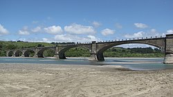
Dyerville is located to the right of this photo along a sliver of land behind state park land along the North Fork of the Eel River. The South Fork merges from the right. Dyerville is bordered on the west side by Humboldt Redwoods State Park, notably Founders Grove. Avenue of the Giants, the old Highway 101, cuts through this portion of the park. The four-lane Highway 101 is also to the right of this photo. Some residents remain in the area generally regarded as Dyerville, which once was a bustling place along the railroad, evidence by the railroad trestle shown in the photo. The railroad is shut down between Willits and Samoa.
Lizenz:
Public domain
Relevante Bilder
Relevante Artikel
Eel River (Kalifornien)Der Eel River ist ein 315 km langer Fluss im Nordwesten des US-Bundesstaates Kalifornien. Er entwässert ein Areal von 9540 km². .. weiterlesen


