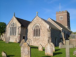
Dawlish StGregory SE
Autor/Urheber:
Attribution:
Das Bild ist mit 'Attribution Required' markiert, aber es wurden keine Informationen über die Attribution bereitgestellt. Vermutlich wurde bei Verwendung des MediaWiki-Templates für die CC-BY Lizenzen der Parameter für die Attribution weggelassen. Autoren und Urheber finden für die korrekte Verwendung der Templates hier ein Beispiel.
Shortlink:
Quelle:
Größe:
768 x 960 Pixel (368151 Bytes)
Beschreibung:
St Gregory's parish church, Dawlish, Devon, seen from the southeast
Lizenz:
Relevante Bilder
![](https://upload.wikimedia.org/wikipedia/commons/thumb/4/47/St_Gregory_the_Great%27s_church%2C_Dawlish_-_interior_-_geograph.org.uk_-_4489159.jpg/250px-St_Gregory_the_Great%27s_church%2C_Dawlish_-_interior_-_geograph.org.uk_-_4489159.jpg)
(c) St Gregory the Great's church, Dawlish - interior by Ruth Sharville, CC BY-SA 2.0
![](https://upload.wikimedia.org/wikipedia/commons/thumb/0/07/188_of_%27The_History_of_Dorchester%2C_Oxfordshire-_British_earthworks-Roman_Camp-Bishopric._And_the_architectural_history_of_the_Church%2C_compiled_from_the_best_authorities._With_a_general_introduction_by_J._H._P%27_%2811154061806%29.jpg/250px-thumbnail.jpg)
![](https://upload.wikimedia.org/wikipedia/commons/thumb/8/89/Dawlish_Parish_Church_-_geograph.org.uk_-_785823.jpg/250px-Dawlish_Parish_Church_-_geograph.org.uk_-_785823.jpg)
(c) paul dickson, CC BY-SA 2.0
![](https://upload.wikimedia.org/wikipedia/commons/thumb/4/40/St_Michael%27s_church%2C_Gittisham_-_geograph.org.uk_-_174037.jpg/250px-St_Michael%27s_church%2C_Gittisham_-_geograph.org.uk_-_174037.jpg)
(c) Derek Harper, CC BY-SA 2.0
![](https://upload.wikimedia.org/wikipedia/commons/thumb/2/20/The_West_Gate_towers%2C_Holy_Cross_Church_and_River_Stour_-_geograph.org.uk_-_744440.jpg/250px-The_West_Gate_towers%2C_Holy_Cross_Church_and_River_Stour_-_geograph.org.uk_-_744440.jpg)
(c) Nick Smith, CC BY-SA 2.0
![](https://upload.wikimedia.org/wikipedia/commons/thumb/2/27/Chancel%2C_All_Saints%27_North_Street%2C_York_-_geograph.org.uk_-_4346380.jpg/250px-Chancel%2C_All_Saints%27_North_Street%2C_York_-_geograph.org.uk_-_4346380.jpg)
(c) Chancel, All Saints' North Street, York by J.Hannan-Briggs, CC BY-SA 2.0
![](https://upload.wikimedia.org/wikipedia/commons/thumb/5/50/The_architectural_history_of_the_University_of_Cambridge%2C_and_of_the_colleges_of_Cambridge_and_Eton_%281886%29_%2814776812114%29.jpg/125px-The_architectural_history_of_the_University_of_Cambridge%2C_and_of_the_colleges_of_Cambridge_and_Eton_%281886%29_%2814776812114%29.jpg)
![](https://upload.wikimedia.org/wikipedia/commons/thumb/4/45/Hazelbury_Bryan%2C_parish_church_of_St._Mary_and_St._James_-_geograph.org.uk_-_506510.jpg/125px-Hazelbury_Bryan%2C_parish_church_of_St._Mary_and_St._James_-_geograph.org.uk_-_506510.jpg)
(c) Chris Downer, CC BY-SA 2.0
![](https://upload.wikimedia.org/wikipedia/commons/thumb/e/ec/St_Mary_the_Virgin%27s_church%2C_Rattery_-_geograph.org.uk_-_1320452.jpg/250px-St_Mary_the_Virgin%27s_church%2C_Rattery_-_geograph.org.uk_-_1320452.jpg)
(c) Ruth Sharville, CC BY-SA 2.0
![](https://upload.wikimedia.org/wikipedia/commons/thumb/8/83/St_Simon%27s_Church%2C_Salisbury_Road_Plymouth_-_geograph.org.uk_-_997715.jpg/250px-St_Simon%27s_Church%2C_Salisbury_Road_Plymouth_-_geograph.org.uk_-_997715.jpg)
(c) Mick Lobb, CC BY-SA 2.0
![](https://upload.wikimedia.org/wikipedia/commons/thumb/f/fa/Hagley%2C_St_John_the_Baptist_-_interior%2C_nave_%28looking_towards_east%29_-_photo_3.jpg/250px-Hagley%2C_St_John_the_Baptist_-_interior%2C_nave_%28looking_towards_east%29_-_photo_3.jpg)
![](https://upload.wikimedia.org/wikipedia/commons/thumb/a/a9/East-Facing_View_inside_the_Church_of_Saint_Mary%2C_Rotherhithe_%2801%29.jpg/250px-East-Facing_View_inside_the_Church_of_Saint_Mary%2C_Rotherhithe_%2801%29.jpg)
![](https://upload.wikimedia.org/wikipedia/commons/thumb/c/c4/Eglwys_Santes_Eurgain_a_Sant_Pedr%2C_Llaneurgain_-_Church_of_St_Eurgain_and_St_Paul%2C_Northop%2C_Flintshire_Cymru_Wales_95.jpg/250px-Eglwys_Santes_Eurgain_a_Sant_Pedr%2C_Llaneurgain_-_Church_of_St_Eurgain_and_St_Paul%2C_Northop%2C_Flintshire_Cymru_Wales_95.jpg)
![](https://upload.wikimedia.org/wikipedia/commons/thumb/d/dd/Dawlish_StAgatha_SE.jpg/250px-Dawlish_StAgatha_SE.jpg)
![](https://upload.wikimedia.org/wikipedia/commons/thumb/3/34/St_Mary_with_All_Saints%2C_Rotherhithe_-_geograph.org.uk_-_2851459.jpg/250px-St_Mary_with_All_Saints%2C_Rotherhithe_-_geograph.org.uk_-_2851459.jpg)
(c) St Mary with All Saints, Rotherhithe by John Salmon, CC BY-SA 2.0
![](https://upload.wikimedia.org/wikipedia/commons/thumb/9/96/St.Katherine%27s_church%2C_Loversall%2C_South_Yorkshire._-_geograph.org.uk_-_104969.jpg/250px-St.Katherine%27s_church%2C_Loversall%2C_South_Yorkshire._-_geograph.org.uk_-_104969.jpg)
(c) Richard Croft, CC BY-SA 2.0
![](https://upload.wikimedia.org/wikipedia/commons/thumb/a/a7/Church_of_the_Blessed_Virgin_Mary_and_St_Leodegarius%2C_Ashby_St_Ledgers_-_geograph.org.uk_-_3720555.jpg/250px-Church_of_the_Blessed_Virgin_Mary_and_St_Leodegarius%2C_Ashby_St_Ledgers_-_geograph.org.uk_-_3720555.jpg)
(c) Church of the Blessed Virgin Mary and St Leodegarius, Ashby St Ledgers by David Purchase, CC BY-SA 2.0
![](https://upload.wikimedia.org/wikipedia/commons/thumb/e/eb/St_Paul%27s_Church%2C_Starcross_-_geograph.org.uk_-_324362.jpg/250px-St_Paul%27s_Church%2C_Starcross_-_geograph.org.uk_-_324362.jpg)
(c) Tony Atkin, CC BY-SA 2.0
![](https://upload.wikimedia.org/wikipedia/commons/thumb/7/7f/The_Nave%2C_looking_West%2C_St._Mary%27s_church%2C_Aldingbourne_-_geograph.org.uk_-_4252267.jpg/250px-The_Nave%2C_looking_West%2C_St._Mary%27s_church%2C_Aldingbourne_-_geograph.org.uk_-_4252267.jpg)
(c) The Nave, looking West, St. Mary's church, Aldingbourne by Derek Voller, CC BY-SA 2.0
![](https://upload.wikimedia.org/wikipedia/commons/thumb/7/71/St_Michaels_Church%2C_Shap_with_Swindale%2C_Interior_-_geograph.org.uk_-_550023.jpg/250px-St_Michaels_Church%2C_Shap_with_Swindale%2C_Interior_-_geograph.org.uk_-_550023.jpg)
(c) Alexander P Kapp, CC BY-SA 2.0
![](https://upload.wikimedia.org/wikipedia/commons/thumb/8/83/St_Paul%2C_Deptford_High_Street%2C_London_SE8_-_West_end-geograph-2076186-by-John-Salmon.jpg/250px-St_Paul%2C_Deptford_High_Street%2C_London_SE8_-_West_end-geograph-2076186-by-John-Salmon.jpg)
(c) John Salmon, CC BY-SA 2.0
![](https://upload.wikimedia.org/wikipedia/commons/thumb/c/c7/Harpford_St_Gregory_from_NE_%282021-08-14%29_16.jpg/250px-Harpford_St_Gregory_from_NE_%282021-08-14%29_16.jpg)
![](https://upload.wikimedia.org/wikipedia/commons/thumb/6/64/St_Giles_in_the_Field%2C_St_Giles_High_Street_-_geograph.org.uk_-_3190984.jpg/250px-St_Giles_in_the_Field%2C_St_Giles_High_Street_-_geograph.org.uk_-_3190984.jpg)
(c) St Giles in the Field, St Giles High Street by John Salmon, CC BY-SA 2.0
![](https://upload.wikimedia.org/wikipedia/commons/thumb/3/3d/Hampton_Bishop%2C_St_Andrew_from_SE%2C_GeoUK_1453936.jpg/250px-Hampton_Bishop%2C_St_Andrew_from_SE%2C_GeoUK_1453936.jpg)
(c) Roger Davies, CC BY-SA 2.0
![](https://upload.wikimedia.org/wikipedia/commons/thumb/f/f6/Interior%2C_All_Saints%27_church%2C_North_Street%2C_York_-_geograph.org.uk_-_4346386.jpg/250px-Interior%2C_All_Saints%27_church%2C_North_Street%2C_York_-_geograph.org.uk_-_4346386.jpg)
(c) Interior, All Saints' church, North Street, York by J.Hannan-Briggs, CC BY-SA 2.0
![](https://upload.wikimedia.org/wikipedia/commons/thumb/d/d9/Winkleigh%2C_parish_church_of_All_Saints_and_war_memorial_-_geograph.org.uk_-_1464723_%28cropped%29.jpg/125px-Winkleigh%2C_parish_church_of_All_Saints_and_war_memorial_-_geograph.org.uk_-_1464723_%28cropped%29.jpg)
(c) Chris Downer, CC BY-SA 2.0
![](https://upload.wikimedia.org/wikipedia/commons/thumb/a/a8/Langford%2C_St._Matthew%27s_Church%2C_c12th_nave_with_Anglo_Saxon_tower_arch_-_geograph.org.uk_-_5441779.jpg/250px-Langford%2C_St._Matthew%27s_Church%2C_c12th_nave_with_Anglo_Saxon_tower_arch_-_geograph.org.uk_-_5441779.jpg)
(c) Langford, St. Matthew's Church: c12th nave with Anglo Saxon tower arch by Michael Garlick, CC BY-SA 2.0
![](https://upload.wikimedia.org/wikipedia/commons/thumb/d/d1/Nave_looking_east%2C_Sts._Peter_and_Paul%2C_Newchurch_-_geograph.org.uk_-_2134078.jpg/250px-Nave_looking_east%2C_Sts._Peter_and_Paul%2C_Newchurch_-_geograph.org.uk_-_2134078.jpg)
(c) Nave looking east, Sts. Peter and Paul, Newchurch by nick macneill, CC BY-SA 2.0
![](https://upload.wikimedia.org/wikipedia/commons/thumb/b/ba/St.Mary_and_All_Saints%27_church%2C_Swarby%2C_Lincs._-_geograph.org.uk_-_90677.jpg/250px-St.Mary_and_All_Saints%27_church%2C_Swarby%2C_Lincs._-_geograph.org.uk_-_90677.jpg)
(c) Richard Croft, CC BY-SA 2.0
![](https://upload.wikimedia.org/wikipedia/commons/thumb/1/12/St_Michael_and_All_Angels_parish_church_in_Steventon_-_geograph.org.uk_-_1257117.jpg/250px-St_Michael_and_All_Angels_parish_church_in_Steventon_-_geograph.org.uk_-_1257117.jpg)
(c) Steve Daniels, CC BY-SA 2.0
![](https://upload.wikimedia.org/wikipedia/commons/thumb/7/7e/St.Mary%27s_church%2C_Mortehoe%2C_Devon_-_geograph.org.uk_-_42517.jpg/250px-St.Mary%27s_church%2C_Mortehoe%2C_Devon_-_geograph.org.uk_-_42517.jpg)
(c) Richard Croft, CC BY-SA 2.0
![](https://upload.wikimedia.org/wikipedia/commons/thumb/5/52/Hayes_%28Bromley%29_St_Mary_the_Virgin_from_north-west_%2801%29.jpg/250px-Hayes_%28Bromley%29_St_Mary_the_Virgin_from_north-west_%2801%29.jpg)
![](https://upload.wikimedia.org/wikipedia/commons/thumb/8/83/Church_of_St_Martin_Cum_Gregory_York_03.jpg/250px-Church_of_St_Martin_Cum_Gregory_York_03.jpg)
![](https://upload.wikimedia.org/wikipedia/commons/thumb/1/11/Southwest_View_of_the_Church_of_Saint_Mary_the_Virgin%2C_Hayes_%2802%29.jpg/250px-Southwest_View_of_the_Church_of_Saint_Mary_the_Virgin%2C_Hayes_%2802%29.jpg)
![](https://upload.wikimedia.org/wikipedia/commons/thumb/b/bc/East_Facing_View_through_the_Nave_of_the_Church_of_All_Saints%2C_Eastchurch_%2801%29.jpg/250px-East_Facing_View_through_the_Nave_of_the_Church_of_All_Saints%2C_Eastchurch_%2801%29.jpg)
![](https://upload.wikimedia.org/wikipedia/commons/thumb/2/2b/Lych_gate_at_Paignton_Parish_Church_-_geograph.org.uk_-_1083990.jpg/250px-Lych_gate_at_Paignton_Parish_Church_-_geograph.org.uk_-_1083990.jpg)
(c) Paul Hutchinson, CC BY-SA 2.0
![](https://upload.wikimedia.org/wikipedia/commons/thumb/c/c1/St_George_and_All_Saints%2C_Beaford_-_geograph.org.uk_-_1411996.jpg/250px-St_George_and_All_Saints%2C_Beaford_-_geograph.org.uk_-_1411996.jpg)
(c) William Cooke, CC BY-SA 2.0
![](https://upload.wikimedia.org/wikipedia/commons/thumb/1/15/St._John_the_Baptist_church%2C_Stanton_St._John_-_geograph.org.uk_-_673357.jpg/250px-St._John_the_Baptist_church%2C_Stanton_St._John_-_geograph.org.uk_-_673357.jpg)
(c) Jonathan Billinger, CC BY-SA 2.0
Relevante Artikel
Liste der Hallenkirchen im Vereinigten Königreich▶ Liste(n) der Hallenkirchen – Übersicht .. weiterlesen