Chapadão do Céu, Goiás
Autor/Urheber:
Coordenação-Geral de Observação da Terra/INPE
Attribution:
Das Bild ist mit 'Attribution Required' markiert, aber es wurden keine Informationen über die Attribution bereitgestellt. Vermutlich wurde bei Verwendung des MediaWiki-Templates für die CC-BY Lizenzen der Parameter für die Attribution weggelassen. Autoren und Urheber finden für die korrekte Verwendung der Templates hier ein Beispiel.
Shortlink:
Quelle:
Größe:
3705 x 2087 Pixel (3674784 Bytes)
Beschreibung:
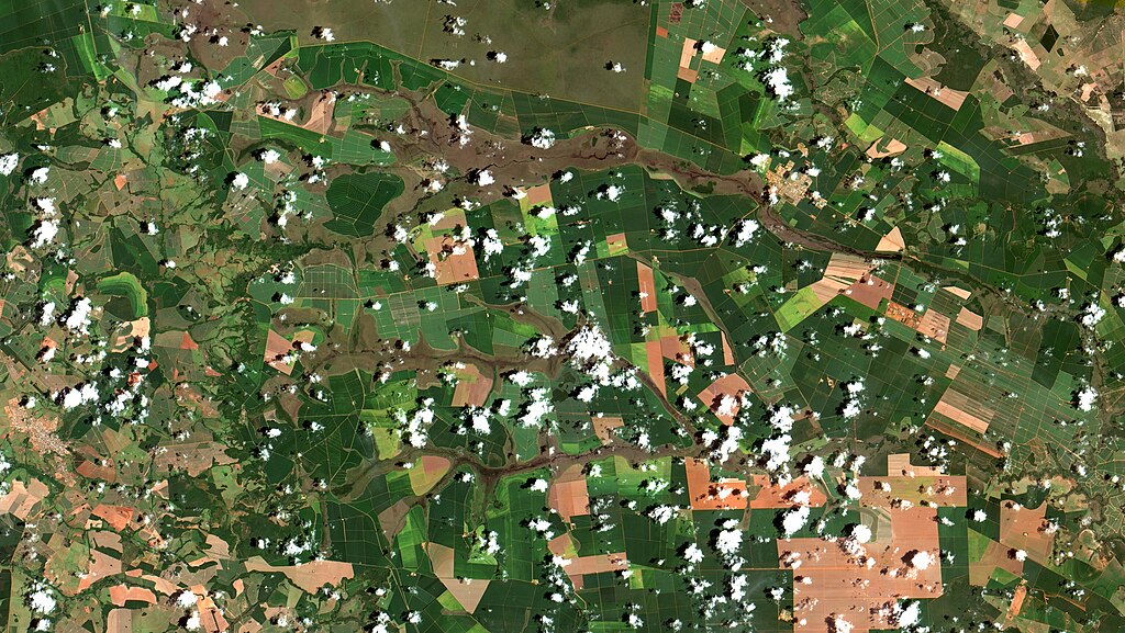
Chapadão do Céu, Goiás. Área urbana em salpicado alaranjado, no alto à dir.. Campo cerrado em marrom, no alto à esq. no Parque Nacional das Emas e acompanhando as várzeas dos rios cruzando a imagem da esq. para a dir.. Os diversos polígonos, formando como que uma colcha de retalhos, são áreas agrícolas. Em verde escuro, quase em fase de colheita, em verde claro recentemente plantadas e em laranja, solo exposto. Nessa região está iniciando a colheita da soja e iniciou em Dezembro a colheita e o plantio do algodão. Milho normalmente é plantado na segunda safra / Chapadão do Céu, Brazil. Town in orangeish saltpepper, at image right top. Savanna fields in brown, at Emas National Park, at left top, and along rivers, crossing image from left to right, lowlands. Polygons patchwork are agricultural areas. In dark green, when near harvest time, recently sown in light green and in orange, exposed soil. Soybeans harvest has just started and cotton started being sown in December. Corn here is usually planted after soy has been harvested.
- chapadãodocéu #goiás #matogrossodosul #parquenacionaldasemas #soja #milho #algodão #agribusiness #soybeans #cotton #agricultura #safra #sensoriamentoremoto #remotesensing #teledetección #télédétection #CBERS4
Imagem / Image CBERS4 MUX Chapadão do Céu, Goiás Coordenadas do centro da imagem / Image center: 18°25'45.8"S 52°45'50.3"W Data / Date: 08-01-2019 / 2019-08-01 RGB 765 (cor verdadeira / true color) Cena / Scene: 162 / 121 Autor / Author: Oton Barros (DSR/OBT/INPE)
Imagem em HD / HD Image
Visite-nos / Visit us: www.dsr.inpe.br
Lizenz:
Relevante Bilder
Relevante Artikel
Chapadão do CéuChapadão do Céu, amtlich portugiesisch Município de Chapadão do Céu, liegt in 725 Metern Höhe im Südwesten des brasilianischen Bundesstaats Goiás und ist der nächstgelegene Zugang zum Emas-Nationalpark. .. weiterlesen


