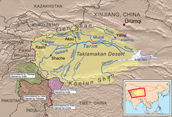
Bm taklamakan


Autor/Urheber:
NASA/Goddard Space Flight Center/Reto Stöckli and Robert Simmon
Größe:
1900 x 950 Pixel (960577 Bytes)
Beschreibung:
Ausschnitt aus Blue Marble-Karte der NASA
Kommentar zur Lizenz:
Image taken from NASA Blue Marble-Project.


License:
For all non-private uses, the terms of use are as follows:

  1. The imagery is free of licensing fees
  2. NASA requires that they be provided a credit as the owners of the imagery

Beyond that, there are two requests by the Visible Earth team:

  1. We request that you provide a credit for the Visible Earth, as the location where you obtained the imagery, with a URL if possible (visibleearth.nasa.gov/)
  2. We further request that you provide a credit to the Earth Observatory team that developed the imagery, again with a URL if permitting (earthobservatory.nasa.gov/)

Again, (1) and (2) are completely optional.

Lizenz:
Public domain
Bild teilen:
Facebook   Twitter   Pinterest   WhatsApp   Telegram   E-Mail
Weitere Informationen zur Lizenz des Bildes finden Sie hier. Letzte Aktualisierung: Tue, 02 Jul 2024 23:50:10 GMT

Relevante Bilder


Relevante Artikel

Tarimbecken

Das Tarimbecken, das sich im äußersten Westen der Volksrepublik China befindet, ist mit etwa 1.020.000 km² Fläche die größte Beckenlandschaft in Zentralasien. .. weiterlesen

Tian Shan

Der Tian Shan, eingedeutscht Tienschan („Himmelsgebirge“), ist ein etwa 2450 km langes, etwa 400 km breites und bis 7439 m hohes Hochgebirge im Norden des innerasiatischen Gebirgssystems Hochasien. Er trennt den Nord- und Südteil der Großlandschaft Turkestan voneinander und erstreckt sich über die zentralasiatischen Staaten Kasachstan, Kirgisistan, Tadschikistan und Usbekistan sowie das Uigurische Autonome Gebiet Xinjiang im Nordwesten der Volksrepublik China. .. weiterlesen