Battle of Culloden (map 02)
(c) User:Celtus, CC BY-SA 3.0
Shortlink:
Quelle:
Größe:
1200 x 774 Pixel (1412464 Bytes)
Beschreibung:
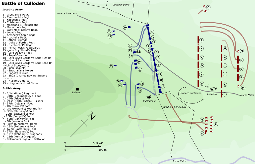
Map of the Battle of Culloden.
This map shows the skewing of the Jacobite front line as the right wing moved forward, but the left wing stayed anchored to the enclosure wall. The result was the right wing was closer to the enemy than the left wing and that gaps appeared in the line as it stretched. To compensate, Sullivan brought up units from the rear to fill in gaps. Cumberland moved over several units to protect his right flank. Hawley moved his cavalry through the enclosure and on to the other side. The Jacobites noticed this and sent several units down to keep an eye on them. The Highland battalion moved into the enclosure and took up position just behind the wall, just in front of the Jacobites' right flank.
This map shows the skewing of the Jacobite front line as the right wing moved forward, but the left wing stayed anchored to the enclosure wall. The result was the right wing was closer to the enemy than the left wing and that gaps appeared in the line as it stretched. To compensate, Sullivan brought up units from the rear to fill in gaps. Cumberland moved over several units to protect his right flank. Hawley moved his cavalry through the enclosure and on to the other side. The Jacobites noticed this and sent several units down to keep an eye on them. The Highland battalion moved into the enclosure and took up position just behind the wall, just in front of the Jacobites' right flank.
Lizenz:
Credit:
Eigenes Werk I used the cavalry unit graphic from this image Image:Battle of Waterloo.svg by User:Ipankonin on the Commons.
Relevante Bilder
Relevante Artikel
Schlacht bei CullodenDie Schlacht von Culloden vom 16. April 1746 zwischen britischen Regierungstruppen und aufständischen Jakobiten fand auf dem Culloden Moor nahe der gleichnamigen Ortschaft östlich von Inverness in Schottland statt und endete mit einem Sieg der Regierungstruppen. .. weiterlesen


