Annual report of the American Scenic and Historic Preservation Society to the legislature of the State of New York. (1901) (14598256699)
Identifier: annualreportofam00amer_2 (find matches)
Title: Annual report of the American Scenic and Historic Preservation Society to the legislature of the State of New York.
Year: 1901 (1900s)
Authors: American Scenic and Historic Preservation Society.
Subjects: Historic buildings Natural monuments Monuments
Publisher: (Albany, N.Y. : s.n.)
Contributing Library: Columbia University Libraries
Digitizing Sponsor: The Durst Organization
View Book Page: Book Viewer
About This Book: Catalog Entry
View All Images: All Images From Book
Click here to view book online to see this illustration in context in a browseable online version of this book.
Text Appearing Before Image:
age of 1G09 that the adjacent triangle of theocean was regarded as an unknown sea. 10 This region, there-fore, offered to Hudson untested possibilities which, with thedescriptions sent to him by Smith and probably obtained fromthe Indians, must have been very tempting. Furthermore, thepassage by latitude 40°, if it should prove to be feasible, wouldavoid the rigors of climate and dangers of ice presented by themore northern route, and, passing through a more habitableregion, would offer larger probabilities of subsistence. In viewof these considerations, and with the new map before Hudsonand his crew, one can readily understand why they voted in 1G09to try the Rio de Guamas passage and why Hudson thus came tothe Hudson river. f Soo reference to River of Oomcz on page 804 following. io This testimony of Juets Journal under date of August 0th to the preva-lent ignorance concerning this portion of the Atlantic coast is very significant,and adds to the importance of Hudsons explorations.
Text Appearing After Image:
240 to bethe rknowfeatuIt istwo 1Straijwhicl1G09,DavisOn tlcenve)Cod aincogi )theretoand bone S(hypotlplored.map had ncnal ofocean -fore, cdescripthe In-passageavoid tmore 1region,of theseand histo try tthe Jhu o Soc r<io Thislent ignoiand adds F1FTEJ3NTII ANN 0A! liEr0IIT. 211 The new map above referred to possesses a literary as wellas an historical interest. When it appeared in 1600, it arousedgreat popular interest. Everybody in London was talking aboutthe new map. This, we infer, from the fact that Shakespeareemployed it in Twelfth Xight in a humorous figure of speechwhich he undoubtedly expected everybody to appreciate. Tounderstand Shakespeares joke, it must be explained that this newmap, like others of the period, had upon it about a dozen wind-roses. A wind-rose is a point from which radiate lines run-ning in the directions of the 32 points of the compass. As theselines, designed to aid the navigator, run as far as they can uponthe map, the lines of the several wind-roses
Note About Images
Relevante Bilder
Relevante Artikel
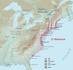
Geschichte der Dreizehn KolonienDie Geschichte der Dreizehn Kolonien umfasst den Zeitraum von der ersten Gründung britischer Kolonien an der nordamerikanischen Ostküste im Jahr 1607 bis zum Ende des Amerikanischen Unabhängigkeitskriegs und dem Frieden von Paris 1783. Thematisch handelt es sich bei ihr um die kolonialzeitliche Vorgeschichte der Vereinigten Staaten. Im größeren Rahmen ist sie Teil der neuzeitlichen Entdeckungs- und Eroberungsgeschichte auf dem amerikanischen Kontinent. Grob unterteilen lässt sie sich in vier Phasen: die frühe Periode der Koloniegründungen, eine von Wachstum und Konsolidierung geprägte Anschlussphase, eine stark von territorialen Auseinandersetzungen zwischen Großbritannien und dem kolonialen Hauptkonkurrenten Frankreich geprägte Periode in der ersten Hälfte des 18. Jahrhunderts und schließlich eine vierte vom Ende des Siebenjährigen Kriegs bis zum Abschluss des Unabhängigkeitskriegs. .. weiterlesen


