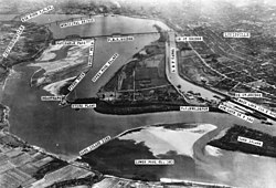
2cornisland
Autor/Urheber:
Victor Collot
Shortlink:
Quelle:
Größe:
450 x 359 Pixel (92441 Bytes)
Beschreibung:
Lizenz:
Public domain
Credit:
Victor Collot: A Journey in North America, Containing a survey of the countries watered by the Mississippi, Ohio, Missouri, and other affluing rivers; with exact observations on the course and soundings of these rivers; and on the towns, villages, hamlets and farms of that part of the new-world; followed by philosophical, political, military and commercial remarks and by a projected line of frontiers and genera limits. 2 Vols., Paris, 1826, Plate 17.
Relevante Bilder
Relevante Artikel
Fourteenth Street BridgeDie Fourteenth Street Bridge ist eine eingleisige Eisenbahnbrücke über den Ohio zwischen Louisville in Kentucky und Clarksville in Indiana. Namensgeber ist die Lage der Zufahrt zur Brücke im Stadtraster von Louisville, entlang der 14. Straße, deren Fläche aber ausschließlich durch den Bahndamm eingenommen wird. Sie führt über die Stromschnellen Falls of the Ohio, die heute größtenteils unterhalb des Wasserspiegels der Staustufe McAlpine Locks and Dam liegen. .. weiterlesen


