2008TC3-groundpath-rev
Autor/Urheber:
George William Herbert (graphic overlay) / US Government (original map)
Shortlink:
Quelle:
Größe:
537 x 579 Pixel (238006 Bytes)
Beschreibung:
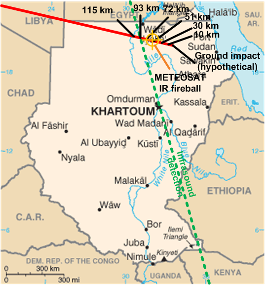
Ground track and probable explosion point in midair of the asteroid 2008 TC3 which entered earth's atmosphere and exploded over Sudan on 2008-10-06.
Original map CIA Factbook. Graphic overlay George William Herbert 2008-10-07. GFDL and CC-BY-3.0 dual licensed.
Ground track from Very near NEO Meteoroid (Mike Kretlow); infrasound track from [1] (Dr Peter Brown); IR fireball location from [2] and [3] (EUMETSAT). The infrasound map image can also be found at [4].![[1]](http://www.minorplanets.org/OLS/images/map-prelim.jpg)
![[2]](http://www.eumetsat.int/groups/ops/documents/image/img_asteroid_impact_hrv.jpg)
![[3]](http://www.eumetsat.int/groups/ops/documents/image/img_asteroid_impact_nat_cols.jpg)
Lizenz:
Public domain
Credit:
Own work modifications to US Government PD / CIA Factbook map of Sudan
Bild teilen:


Relevante Bilder
.gif)


Relevante Artikel
2008 TC32008 TC3 (provisorische Bezeichnung der Entdecker: 8TA9D69) war der erste Asteroid, für den eine Kollision mit der Erde (Eintritt in die Atmosphäre) korrekt vorausberechnet wurde. Der Absturz erfolgte am 7. Oktober 2008 über der Nubischen Wüste. Monate später konnten Bruchstücke des Asteroiden (Meteoriten) im Absturzgebiet geborgen werden. .. weiterlesen