Zyklonsaison im Nordindik 2013
 Alle Stürme der Saison | |
| Bildung des ersten Sturms | 10. Mai |
|---|---|
| Auflösung des letzten Sturms | 13. Dezember |
| Stärkster Sturm | Phailin – 940 hPa (mbar), 115 kn (215 km/h) (3-minütig) |
| Depressions | 10 |
| Deep Depressions | 6 |
| Zyklonische Stürme | 5 |
| Schwere zyklonische Stürme | 5 |
| Opferzahl gesamt | 323 total |
| Gesamtschaden | 1,5 Milliarden $ (2013) |
| Nordindik-Zyklonsaison 2011, 2012, 2013, 2014, 2015 | |
Die Zyklonsaison im Nordindik 2013 hat keine offiziellen Grenzen wie in anderen Becken üblich, sondern läuft das ganze Jahr hindurch. Die tropischen Wirbelstürme bilden sich allerdings in diesem Becken in der Regel zwischen April und Dezember, wobei die Monate vor und nach der Monsunsaison, also April/Mai und Oktober/November die aktivsten sind. Einen tropischen Wirbelsturm im Indischen Ozean bezeichnet man als Zyklon.
Das zuständige Regional Specialized Meteorological Centre (RSMC) ist das India Meteorological Department in Neu-Delhi. Dieses vergibt für diejenigen tropischen Wirbelstürme, die mindestens den Status eines Zyklons erreichen, einen Namen. Tiefdruckgebiete (je nach Windgeschwindigkeit depressions oder deep depressions) werden fortlaufend nummeriert, wobei die Buchstabenkombination BOB anzeigt, dass sich das System im Golf von Bengalen bildete. Die Buchstaben ARB stehen sinngemäß für das Arabische Meer.
Durch das Joint Typhoon Warning Center (JTWC) in Honolulu werden für die US-amerikanischen Einrichtungen im Indischen Ozean eigenständige Warnungen und Prognosen ausgegeben. Durch das JTWC erfolgt die Einstufung nach der Saffir-Simpson-Hurrikan-Windskala, das RSMC wendet für die Einstufung eigene Kriterien an, denen unter anderem die Messung der andauernden Windgeschwindigkeit auf Basis einer dreiminütigen Beobachtung zugrunde liegt.
Sturmnamen
Tropische Wirbelstürme im Indischen Ozean werden durch das RSMC des India Meteorological Department benannt. Die Namen werden jeweils nur einmal verwendet, es werden also keine Namen verheerender Stürme nach Ende der Saison von der Liste der Namen tropischer Wirbelstürme gestrichen. Die folgenden Namen wurden für benannte Stürme benutzt:
- Mahasen, Phailin, Helen, Lehar, Madi
Stürme
Zyklonischer Sturm Mahasen (01B)
| Zyklonischer Sturm (IMD) | |||
|---|---|---|---|
| Tropischer Sturm | |||
| |||
| Dauer | 10. Mai – 17. Mai | ||
| Intensität | 45 kn (85 km/h) (3-minütig), 990 hPa | ||
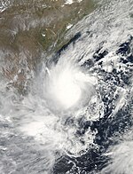
Am 4. Mai bildete sich einige hundert Kilometer westlich der Nordspitze Sumatras Konvektion. Dieses Gebiet zog zunächst nach Osten und organisierte sich am 8. Mai in ein Tiefdruckgebiet. Weitere Organisierung des Systems führte am 10. Mai zu einem Tropical Cyclone Formation Alert (TCFA) durch das Joint Typhoon Warning Center und einige Stunden später zur Klassifizierung als 01B[1] bzw. der Einstufung als Depression BOB 01 durch das RSMC Neu-Delhi,[2] der noch am selben Tag die Aufstufung in eine Deep Depression folgte.[3] In den Morgenstunden des 11. Mai aktualisierte das RSMC Neu-Delhi das System zu einem Zyklonischen Sturm und nannte diesen Mahasen.[4] Aufgrund von nur leichter Windscherung konnte sich Mahasen in den folgenden Tagen weiter verstärken und erreichte am Morgen des 12. Mai 1-minütige Windgeschwindigkeiten von rund 95 km/h.[5] Nach seinem Höhepunkt konnte Mahasen konstant seine Intensität halten und zog Richtung Nordwesten.[6] Am 14. Mai zog der Sturm eine Kurve und zog fortan Richtung Nordosten und ging am 16. Mai 30 km südlich von Feni, Bangladesch an Land.[7] Nachdem Mahasen immer weiter ins Landesinnere zog, veröffentlichte das JTWC die letzte Warnung zu dem Sturm.[8] Das IMD stufte Mahasen am Abend zu einer Deep Depression herab.[9] Am 17. Mai löste sich das System über Nagaland vollständig auf.[10]
Durch die Auswirkungen des Sturms wurden mindestens 36 Menschen getötet: 3 in Indonesien,[11] 7 in Sri Lanka, 8 in Andhra Pradesh (Indien),[12] 17 in Bangladesch[13] und einer in Thailand.[14] Zudem ist ein Rettungsboot vor der Küste Myanmars mit 100 Menschen and Bord gesunken. Bei dem Unglück konnten 42 Menschen gerettet werden, 31 Leichen wurden an der Küste von Myanmar gefunden.[13] In Sri Lanka haben 3000 Menschen ihr Haus verloren und sind obdachlos.[15] Mehr als 160.000 Menschen wurden aus den Küstenstreifen in Myanmar ins Landesinnere evakuiert.[16] 15.000 bis 50.000 Lehmhütten in Bangladesch wurden von dem Sturm zerstört.[17] Insgesamt sind 8,2 Millionen Menschen durch Mahasen betroffen.[18]
Depression BOB 02
| Depression (IMD) | |||
|---|---|---|---|
| |||
| Dauer | 29. Mai – 31. Mai | ||
| Intensität | 25 kn (45 km/h) (3-minütig), 990 hPa | ||
Am 28. Mai bildete sich über dem nördlichen Golf von Bengalen ein Gebiet niedrigen Luftdrucks. Am folgenden Tag wurde es vom IMD zu einer Depression aktualisiert.[19] Am Abend desselben Tages ging das System über Westbengalen an Land[20] und blieb am 30. Mai im Landesinneren, bevor es sich am 31. Mai über Jharkhand auflöste.[21]
Depression BOB 03
| Depression (IMD) | |||
|---|---|---|---|
| |||
| Dauer | 30. Juli – 1. August | ||
| Intensität | 25 kn (45 km/h) (3-minütig), 990 hPa | ||
Am 29. Juli bildete sich über dem Golf von Bengalen ein Gebiet niedrigen Luftdrucks. Das System organisierte sich und das Indian Meteorological Department (IMD) aktualisierte es früh am 30. Juli zu einer Depression. Am selben Abend ging diese über der Grenzregion zwischen Odisha und Westbengalen an Land. Nachdem sie über Land nach Westen zog, löste sie sich am 1. August über Madhya Pradesh auf.
Land Depression 01
| Depression (IMD) | |||
|---|---|---|---|
| |||
| Dauer | 20. August – 23. August | ||
| Intensität | 25 kn (45 km/h) (3-minütig), 990 hPa | ||
Am 16. August bildete sich über dem Golf von Bengalen ein monsunales Tiefdruckgebiet, das sich nach und nach intensivierte und früh am 20. August über dem küstennahen Westbengalen und dem Norden von Odisha und Jharkhand zu einer Depression organisierte. Während der folgenden Tage zog das Sturmsystem in westnordwestlicher Richtung, bis es sich am 23. August in ein ausgeprägtes Tiefdruckgebiet abschwächte.
Für die küstennahen Bereiche Westbengalens brachte die Depression starke Niederschläge mit sich, und in Kalkutta fielen innerhalb von drei Tagen 206 mm Regen, was zu überfluteten Straßen führte. Mindestens vier Personen wurden in dem Bundesstaat bei mit dem Regen in Zusammenhang stehenden Ereignissen getötet.[22]
Sehr schwerer zyklonischer Sturm Phailin (02B)
| Extrem schwerer zyklonischer Sturm (IMD) | |||
|---|---|---|---|
| Kategorie-5-Zyklon | |||
| |||
| Dauer | 8. Oktober (Aus Westpazifik) – 14. Oktober | ||
| Intensität | 115 kn (215 km/h) (3-minütig), 940 hPa | ||
Deep Depression ARB 01 (03A)
| Deep Depression (IMD) | |||
|---|---|---|---|
| Tropischer Sturm | |||
| |||
| Dauer | 8. November – 11. November | ||
| Intensität | 30 kn (55 km/h) (3-minütig), 1002 hPa | ||
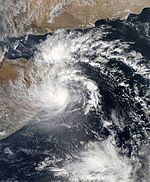
Anfang November bildete sich westlich der Malediven über dem Arabischen Meer ein Tiefdruckgebiet, das langsam westwärts driftete und sich am 8. November in eine Depression organisierte.[23] Das Joint Typhoon Warning Center (JTWC) löste am gleichen Tag einen Tropical Cyclone Formation Alert (TCFA) aus und stellte fest, dass das System in einen Bereich zog, der die weitere Entwicklung begünstigte.[24] Am nächsten Morgen stufte das IMD das System als Deep Depression ein,[25] und das JTWC meldete Windgeschwindigkeiten von 35 Knoten in der Nähe des bodennahen Zirkulationszentrums, was das System nach der Saffir-Simpson-Hurrikan-Windskala als tropischen Sturm klassifiziert.[26] Nachdem das System nahezu einen Tag quasi bewegungslos verharrte, überquerte der Sturm die Küste Somalias in der Nacht vom 10. auf den 11. November.[27] Durch den Einfluss des Festlandes verlor das System schnell seine Organisation und das JTWC gab seine letzte Warnung aus,[28] auch das IMD stufte den Sturm ab in ein ausgeprägtes Tiefdruckgebiet und gab sein letztes Bulletin aus.
ARB 01 verursachte heftige Schäden in der nordsomalischen Region Puntland, Hunderte von Häusern und Vieh wurde von der Sturmflut weggespült, mindestens 100 Personen starben und weitere sind vermisst. Die Regierung des Defactoregimes Puntland erklärte einen Katastrophennotstand.[29]
Depression BOB 05 (30W)
| Depression (IMD) | |||
|---|---|---|---|
| Tropischer Sturm | |||
| |||
| Dauer | 13. November (Aus Westpazifik) – 17. November | ||
| Intensität | 25 kn (45 km/h) (3-minütig), 1003 hPa | ||
Schwerer zyklonischer Sturm Helen (04B)
| Schwerer zyklonischer Sturm (IMD) | |||
|---|---|---|---|
| Kategorie-1-Zyklon | |||
| |||
| Dauer | 19. November – 23. November | ||
| Intensität | 55 kn (100 km/h) (3-minütig), 990 hPa | ||
Sehr schwerer zyklonischer Sturm Lehar (05B)
| Sehr schwerer zyklonischer Sturm (IMD) | |||
|---|---|---|---|
| Kategorie-1-Zyklon | |||
| |||
| Dauer | 23. November (Aus Westpazifik) – 28. November | ||
| Intensität | 75 kn (140 km/h) (3-minütig), 980 hPa | ||
Sehr schwerer zyklonischer Sturm Madi (06B)
| Sehr schwerer zyklonischer Sturm (IMD) | |||
|---|---|---|---|
| Kategorie-2-Zyklon | |||
| |||
| Dauer | 6. Dezember – 13. Dezember | ||
| Intensität | 65 kn (120 km/h) (3-minütig), 986 hPa | ||
Saisonüberblick
Siehe auch
- Südpazifische Zyklonsaisons: 2012–2013, 2013–2014
- Pazifische Taifunsaison 2013
- Australische Zyklonsaisons: 2012–2013, 2013–2014
- Atlantische Hurrikansaison 2013
- Zyklonsaisons im Südwestindik: 2012–2013, 2013–2014
- Pazifische Hurrikansaison 2013
Einzelnachweise
- ↑ Tropical Cyclone 01B (One) JTWC Warning 001. Joint Typhoon Warning Center, archiviert vom ; abgerufen am 10. Mai 2013 (englisch).
- ↑ Tropical Weather Outlook for North Indian Ocean – Issued at 1200 UTC of 10 May, 2013. India Meteorological Department, archiviert vom am 17. Juli 2013; abgerufen am 10. Mai 2013 (englisch). Info: Der Archivlink wurde automatisch eingesetzt und noch nicht geprüft. Bitte prüfe Original- und Archivlink gemäß Anleitung und entferne dann diesen Hinweis.
- ↑ Tropical Weather Outlook for North Indian Ocean – Issued at 1500 UTC of 10 May, 2013. India Meteorological Department, archiviert vom am 17. Juli 2013; abgerufen am 10. Mai 2013 (englisch). Info: Der Archivlink wurde automatisch eingesetzt und noch nicht geprüft. Bitte prüfe Original- und Archivlink gemäß Anleitung und entferne dann diesen Hinweis.
- ↑ Cyclonic Storm Mahasen – CWIND Bulletin Number 005. India Meteorological Department, 11. Mai 2013, archiviert vom am 21. April 2013; abgerufen am 11. Mai 2013 (englisch). Info: Der Archivlink wurde automatisch eingesetzt und noch nicht geprüft. Bitte prüfe Original- und Archivlink gemäß Anleitung und entferne dann diesen Hinweis.
- ↑ Tropical Cyclone 01B (Mahasen) JTWC Warning 008. Joint Typhoon Warning Center, 12. Mai 2013, archiviert vom am 6. Oktober 2013; abgerufen am 16. Mai 2013 (englisch). Info: Der Archivlink wurde automatisch eingesetzt und noch nicht geprüft. Bitte prüfe Original- und Archivlink gemäß Anleitung und entferne dann diesen Hinweis.
- ↑ Tropical Cyclone 01B (Mahasen) JTWC Warning 017. Joint Typhoon Warning Center, 14. Mai 2013, archiviert vom ; abgerufen am 16. Mai 2013 (englisch).
- ↑ Cyclonic Storm Mahasen – CWIND Bulletin Number 032. India Meteorological Department, 16. Mai 2013, archiviert vom am 6. Juni 2013; abgerufen am 16. Mai 2013 (englisch). Info: Der Archivlink wurde automatisch eingesetzt und noch nicht geprüft. Bitte prüfe Original- und Archivlink gemäß Anleitung und entferne dann diesen Hinweis.
- ↑ Tropical Cyclone 01B (Mahasen) JTWC Warning 025. Joint Typhoon Warning Center, 16. Mai 2013, archiviert vom am 6. Oktober 2013; abgerufen am 17. Mai 2013 (englisch). Info: Der Archivlink wurde automatisch eingesetzt und noch nicht geprüft. Bitte prüfe Original- und Archivlink gemäß Anleitung und entferne dann diesen Hinweis.
- ↑ Cyclonic Storm Mahasen – CWIND Bulletin Number 033. India Meteorological Department, 16. Mai 2013, archiviert vom am 6. Juni 2013; abgerufen am 17. Mai 2013 (englisch). Info: Der Archivlink wurde automatisch eingesetzt und noch nicht geprüft. Bitte prüfe Original- und Archivlink gemäß Anleitung und entferne dann diesen Hinweis.
- ↑ Cyclonic Storm Mahasen – CWIND Bulletin Number 035. India Meteorological Department, 17. Mai 2013, archiviert vom am 6. Juni 2013; abgerufen am 1. Juni 2013 (englisch). Info: Der Archivlink wurde automatisch eingesetzt und noch nicht geprüft. Bitte prüfe Original- und Archivlink gemäß Anleitung und entferne dann diesen Hinweis.
- ↑ Aris Cahyadi: Aceh Landslide Kills 3 Bus Passengers. The Jakarta Globe, 13. Mai 2013, archiviert vom am 26. Juni 2013; abgerufen am 17. Mai 2013 (englisch).
- ↑ Eight killed, four injured in Andhra Pradesh cyclonic storm. NDTV, 13. Mai 2013, abgerufen am 16. Mai 2013 (englisch).
- ↑ a b "Mahasen" fordert mindestens 17 Menschenleben. N24, 17. Mai 2013, abgerufen am 17. Mai 2013.
- ↑ Turbulent seas at west coast; 1 person killed during storm's passing. Thai News, 14. Mai 2013, archiviert vom am 16. Juni 2013; abgerufen am 16. Mai 2013 (englisch).
- ↑ Cyclone ‘Mahasen’hits Sri Lanka, seven killed. In: World › South Asia › Collections. The Times of India, 14. Mai 2013, archiviert vom am 13. Juni 2013; abgerufen am 5. September 2023 (englisch).
- ↑ Golf von Bengalen: Hunderttausende fliehen vor Zyklon "Mahasen". Der Spiegel, 15. Mai 2013, abgerufen am 16. Mai 2013.
- ↑ "Mahasen" zerstört tausende Lehmhütten. Süddeutsche Zeitung, 17. Mai 2013, abgerufen am 17. Mai 2013.
- ↑ UN: Cyclone Mahasen threatens 8.2 million people. Yahoo! News, 15. Mai 2013, abgerufen am 16. Mai 2013 (englisch).
- ↑ Depression BOB 02 – CWIND Bulletin Number 001. India Meteorological Department, 29. Mai 2013, archiviert vom ; abgerufen am 3. Juni 2013 (englisch).
- ↑ Tropical Weather Outlook for North Indian Ocean – Issued at 1600 UTC of 29 May, 2013. India Meteorological Department, 29. Mai 2013, archiviert vom ; abgerufen am 3. Juni 2013 (englisch).
- ↑ Depression BOB 02 – CWIND Bulletin Number 013. India Meteorological Department, 31. Mai 2013, archiviert vom ; abgerufen am 3. Juni 2013 (englisch).
- ↑ Telegraph India: As if the downpour weren’t enough, there’s strong tide stirring too, Telegraph India, 21. August 2013. Abgerufen am 22. Oktober 2013. (englisch)
- ↑ IMD Special Tropical Weather Outlook – November 8, 2013. India Meteorological Department, archiviert vom ; abgerufen am 8. November 2013 (englisch).
- ↑ Tropical Cyclone Formation Alert WTIO21 Issued at 08 November 2013/1200Z. Joint Typhoon Warning Center, archiviert vom ; abgerufen am 13. November 2013 (englisch).
- ↑ India Meteorological Department: IMD Special Tropical Weather Outlook – 0300 UTC, November 9, 2013. Archiviert vom ; abgerufen am 9. November 2013 (englisch).
- ↑ Tropical Cyclone Warning 03 – Tropical Cyclone 03A. Joint Typhoon Warning Center, archiviert vom ; abgerufen am 9. November 2013 (englisch).
- ↑ India Meteorological Department: IMD Special Tropical Weather Outlook – 0300 UTC, 11 November 2013. India Meteorological Department, archiviert vom ; abgerufen am 11. November 2013 (englisch).
- ↑ Joint Typhoon Warning Center: Tropical Cyclone 03A (Three) Warning #10 (Final Warning) Issued at 11 November 2013/0300 UTC. Joint Typhoon Warning Center, archiviert vom ; abgerufen am 13. November 2013 (englisch).
- ↑ Abdiqani Hassan: Storms kills about 100 in Somalia’s Puntland, more missing, 11. November 2013. Abgerufen am 12. November 2013. (englisch)
Auf dieser Seite verwendete Medien
Track map of Very Severe Cyclonic Storm Madi of the 2013 North Indian Ocean cyclone season. The points show the location of the storm at 6-hour intervals. The colour represents the storm's maximum sustained wind speeds as classified in the (see below), and the shape of the data points represent the nature of the storm, according to the legend below.
Storm type
Track map of Tropical Depression Wilma/Depression BOB 05 of the 2013 Pacific typhoon season and the 2013 North Indian Ocean cyclone season. The points show the location of the storm at 6-hour intervals. The colour represents the storm's maximum sustained wind speeds as classified in the (see below), and the shape of the data points represent the nature of the storm, according to the legend below.
Storm type
Depression BOB 02 over the Bay of Bengal on 29 May 2013.
Track map of Depression BOB 03 of the 2013 North Indian Ocean cyclone season. The points show the location of the storm at 6-hour intervals. The colour represents the storm's maximum sustained wind speeds as classified in the (see below), and the shape of the data points represent the nature of the storm, according to the legend below.
Storm type
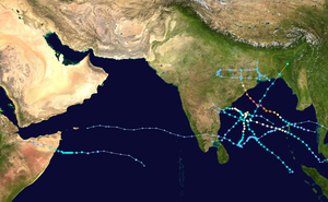
This map shows the tracks of all tropical cyclones in the 2013 North Indian Ocean cyclone season. The points show the location of each storm at 6-hour intervals. The colour represents the storm's maximum sustained wind speeds as classified in the Saffir-Simpson Hurricane Scale (see below), and the shape of the data points represent the type of the storm. Map generation parameters: --xmin 45 --xmax 100
Mahasen formed as a tropical storm over the northern Indian Ocean on May 10, 2013. On May 13, the U.S. Navy’s Joint Typhoon Warning Center (JTWC) reported that Mahasen was moving northward over the Bay of Bengal, headed in the direction of Bangladesh and northeastern India. The storm had maximum sustained winds of 50 knots (95 kilometers per hour) and gusts up to 65 knots (120 kilometers per hour). Within 72 hours, the JTWC reported, sustained wind speeds were expected to increase to 70 knots (130 kilometers per hour).
The Moderate Resolution Imaging Spectroradiometer (MODIS) on NASA’s Aqua satellite captured this natural-color image on May 13, 2013. Mahasen lacked a distinct eye, but still sported a rough apostrophe shape typical of strong storms. Clouds extended along the coast of India and over Sri Lanka.
The JTWC reported that the storm was located roughly 630 nautical miles (1,170 kilometers) south-southwest of Kolkata (Calcutta). The JTWC forecast map showed Mahasen moving northward over the Bay of Bengal before turning slightly toward the northeast, making landfall around May 16.Tropical Cyclone Giri (04B) over Myanmar
Track map of Depression BOB 02 of the 2013 North Indian Ocean cyclone season. The points show the location of the storm at 6-hour intervals. The colour represents the storm's maximum sustained wind speeds as classified in the (see below), and the shape of the data points represent the nature of the storm, according to the legend below.
Storm type
Track map of Cyclone Viyaru of the 2013 North Indian Ocean cyclone season. The points show the location of the storm at 6-hour intervals. The colour represents the storm's maximum sustained wind speeds as classified in the (see below), and the shape of the data points represent the nature of the storm, according to the legend below.
Storm type
Severe Cyclonic Storm Lehar over the Bay of Bengal on 25 November 2013.
Extremely Severe Cyclonic Storm Phailin at peak intensity over the Bay of Bengal on 11 October 2013.
Depression BOB 03 over the Bay of Bengal on 30 July 2013.
The disturbance which later became Land Depression 01, seen here as a well marked low pressure on August 19, 2013 over the Bay of Bengal
Track map of Extremely Severe Cyclonic Storm Phailin of the 2013 North Indian Ocean cyclone season. The points show the location of the storm at 6-hour intervals. The colour represents the storm's maximum sustained wind speeds as classified in the (see below), and the shape of the data points represent the nature of the storm, according to the legend below.
Storm type
Track map of Cyclone Lehar of the 2013 North Indian Ocean cyclone season. The points show the location of the storm at 6-hour intervals. The colour represents the storm's maximum sustained wind speeds as classified in the (see below), and the shape of the data points represent the nature of the storm, according to the legend below.
Storm type
Very Severe Cyclonic Storm Madi on December 10, 2013
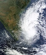
The Moderate Resolution Imaging Spectroradiometer (MODIS) on NASA’s Aqua satellite captured this image of Cyclone 04B (Helen) on November 21, 2013. The cyclone was weakening as it moved northwest and was expected to make landfall in the state of Andhra Pradesh as a tropical storm or category 1 cyclone overnight on November 21–22. Indian government authorities were preparing coastal areas for possible evacuations. At 1500 Universal Time (8 p.m. local time) on November 21, Helen had maximum sustained winds of 102 kilometers (63 miles) per hour, and maximum wave heights of up to 6 meters (20 feet).
Track map of Deep Depression ARB 01 of the 2013 North Indian Ocean cyclone season. The points show the location of the storm at 6-hour intervals. The colour represents the storm's maximum sustained wind speeds as classified in the (see below), and the shape of the data points represent the nature of the storm, according to the legend below.
Storm type
Tropical Depression Wilma over the Bay of Bengal on 15 November 2013
Track map of Land Depression 01 of the 2013 North Indian Ocean cyclone season. The points show the location of the storm at 6-hour intervals. The colour represents the storm's maximum sustained wind speeds as classified in the (see below), and the shape of the data points represent the nature of the storm, according to the legend below.
Storm type
Deep Depression ARB 01 on November 10, 2013
Track map of Severe Cyclonic Storm Helen of the 2013 North Indian Ocean cyclone season. The points show the location of the storm at 6-hour intervals. The colour represents the storm's maximum sustained wind speeds as classified in the (see below), and the shape of the data points represent the nature of the storm, according to the legend below.
Storm type


