Zagai
| Zagai Island (Dungeness) | ||
|---|---|---|
 | ||
| Gewässer | Pazifischer Ozean | |
| Inselgruppe | Torres-Strait-Inseln | |
| Geographische Lage | 9° 51′ 18″ S, 142° 55′ 12″ O | |
| Länge | 6,3 km | |
| Breite | 2,7 km | |
| Fläche | 9,28 km² | |
| Höchste Erhebung | 21 m | |
| Einwohner | unbewohnt | |
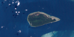
Zagai, auch als Dungeness oder Giaka bekannt, ist eine unbewohnte Insel im mittleren Nordosten der Torres Strait, einer Wasserstraße zwischen Australien und Papua-Neuguinea. Die 9,28 km² große Insel ist durch einen schmalen Durchgang im Osten (Basilisk Passage) vom großen Korallenriff Warroir Reef getrennt.
Die üppig bewaldete Insel Zagai liegt rund 20 Kilometer nordnordöstlich von Sassie Island, der zweitgrößte Inseln in der Inselregion der Central Islands.
Die Namensvariante Giaka ist namensgebend für die Katastralgemeinde Parish of Giaka im County of Torres.
Siehe auch
Auf dieser Seite verwendete Medien
Autor/Urheber: Uwe Dedering, Lizenz: CC BY-SA 3.0
Location map of Queensland, Australia
Equirectangular projection, N/S stretching 106 %. Geographic limits of the map:
- N: 9.0° S
- S: 29.5° S
- W: 137.5° E
- E: 154.0° E
Zagai Island, aka Dungeness Island, Torres Strait Islands, Queensland, Australia
(c) Kelisi aus der englischsprachigen Wikipedia, CC BY-SA 3.0
A map of the Torres Strait Islands. I have endeavoured to use native names wherever I could find them. If you can suggest ways in which this map could be made more up to date, don't hesitate to leave me a message to that effect.
This map's source is here, with the uploader's modifications, and the GMT homepage says that the tools are released under the GNU General Public License.


