Yorkshire Wolds Way
| Yorkshire Wolds Way | |
|---|---|
 (c) Jeremy Howat, CC BY-SA 2.0 Weg bei Bratt Wood | |
| Daten | |
| Länge | 127 km |
| Lage | nördliches England |
| Markierungszeichen | stilisierte aufrechte weiße Eichel auf braunem Grund |
| Startpunkt | Hessle 53° 43′ 0″ N, 0° 26′ 0″ W |
| Zielpunkt | Filey 54° 13′ 0″ N, 0° 17′ 0″ W |
| Typ | Fernwanderweg |
| Höhenunterschied | 215 m |
| Höchster Punkt | Nahe Thixendale, 215 m |
| Niedrigster Punkt | Filey, Meereshöhe |
| Schwierigkeitsgrad | leicht |
| Jahreszeit | ganzjährig |
| Aussichtspunkte | Humber-Brücke |
Der Yorkshire Wolds Way ist ein Wanderweg in England. Er wurde am 2. Oktober 1982 als National Trail im Land eingeweiht und führt von Hessle bei Hull in East Riding of Yorkshire nach Norden und Nordosten über die Yorkshire Wolds bis nach Filey, einer Kleinstadt an der Nordseeküste in North Yorkshire. Der Weg ist 127 km lang.
Fotografien
 (c) Oliver Dixon, CC BY-SA 2.0Markierung für den Startpunkt
 (c) Paul Harrop, CC BY-SA 2.0Weg und Grenzstein in East Dale
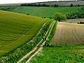 (c) Roger Gilbertson, CC BY-SA 2.0Weg bei North Newbald
 (c) Peter Church, CC BY-SA 2.0Wegweiser
Literatur
- David Clensy: Walking the Wolds Way. Yorkshire on foot, from Hull to Filey & five East Yorkshire tales. Eigenverlag, s. l. 2007, ISBN 978-1-4303-1019-8.
Weblinks
Commons: Yorkshire Wolds Way – Sammlung von Bildern, Videos und Audiodateien
Auf dieser Seite verwendete Medien
OOjs UI icon mapPin-progressive.svg
(c) OOjs UI Team and other contributors, MIT
An icon from the OOjs UI MediaWiki lib.
(c) OOjs UI Team and other contributors, MIT
An icon from the OOjs UI MediaWiki lib.
Bratt Wood Nunburnholme.jpg
(c) Jeremy Howat, CC BY-SA 2.0
Yorkshire Wolds Way through Bratt Wood, Nunburnholme in the East Riding of Yorkshire, England.
(c) Jeremy Howat, CC BY-SA 2.0
Yorkshire Wolds Way through Bratt Wood, Nunburnholme in the East Riding of Yorkshire, England.

The Yorkshire Wolds Way 1.jpg
(c) Peter Church, CC BY-SA 2.0
The Yorkshire Wolds Way, Hessle, East Riding of Yorkshire, England.
A good long walk! The start of the path, which weaves a route along the escarpment and dry valleys of the Yorkshire wolds, is through the wooded area just before the Hessle Foreshore, and the Humber Bridge.

Boundary stone in East Dale - geograph.org.uk - 702155.jpg
(c) Paul Harrop, CC BY-SA 2.0
Boundary stone in East Dale, Low Hunsley, East Riding of Yorkshire, England.
This is one of a number of boundary stones along the edge of the Yorkshire Wolds Way in East Dale. This one reads "south end of Hunsley fence". They appear to mark the edge of the Drewton Estate which occupies land to the west.

Marker at the beginning of the Wolds Way - geograph.org.uk - 120094.jpg
(c) Oliver Dixon, CC BY-SA 2.0
Marker at the beginning of the Yorkshire Wolds Way, Hessle, East Riding of Yorkshire, England.
The Yorkshire Wolds Way, probably the least-known National Trail runs for 79 miles from Hessle Foreshore to Filey Brigg, where it leads straight on into another National Trail, the Cleveland Way.

Walkers on The Wolds Way - geograph.org.uk - 182419.jpg
(c) Roger Gilbertson, CC BY-SA 2.0
Walkers on The Yorkshire Wolds Way, east north east of North Newbald, East Riding of Yorkshire, England.
The Yorkshire Wolds Way is a 79 mile, low-level, long distance footpath which can be walked in stages at any time of the year.
(c) Roger Gilbertson, CC BY-SA 2.0
Walkers on The Yorkshire Wolds Way, east north east of North Newbald, East Riding of Yorkshire, England.
The Yorkshire Wolds Way is a 79 mile, low-level, long distance footpath which can be walked in stages at any time of the year.
Acorn Britain National Trails Symbol.svg
Eichel-Symbol zur Routenführung der National Trails in Großbritanien
Eichel-Symbol zur Routenführung der National Trails in Großbritanien