Yorke-Inseln
| Yorke-Inseln | |
|---|---|
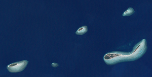
| Landsat-Bild der Inselgruppe | |
| Gewässer | Pazifischer Ozean |
| Archipel | Torres-Strait-Inseln |
| Geographische Lage | 9° 45′ S, 143° 23′ O |
| Anzahl der Inseln | 6 |
| Hauptinsel | Yorke Island (Masig) |
| Gesamte Landfläche | 2,66 km² |
| Einwohner | 270 (2016) |
Die Yorke-Inseln sind eine australische Inselgruppe im Norden des Archipels der Torres-Strait-Inseln. Sie liegen etwa 85 km südöstlich von Papua-Neuguinea und 135 km nordöstlich der Nordspitze Australiens. Die Inselgruppe grenzt im Osten an die Murray-Inseln im Süden an die Bourke-Inseln.
Es handelt sich bei den Yorke-Inseln um kleine Koralleninseln. Lediglich die Hauptinsel Yorke ist bewohnt.[1]
Die Gruppe besteht aus sechs Inseln, von denen Yorke und Kodall auf einem gemeinsamen Riff aufliegen:
| Inselname | Bevölkerung (2016) | Fläche km² | Geokoordinaten |
|---|---|---|---|
| Yorke Island (Masig) | 270 | 1,62 | 9° 45′ S, 143° 25′ O |
| Kodall Islet | - | 0,30 | 9° 44′ S, 143° 27′ O |
| Keats Island (Homogar) | - | 0,05 | 9° 42′ S, 143° 26′ O |
| Marsden Islet (Igab) | - | 0,21 | 9° 43′ S, 143° 22′ O |
| Rennell Island (Mawarr) | - | 0,46 | 9° 46′ S, 143° 16′ O |
| Smith Cay | - | 0,02 | 9° 46′ S, 143° 19′ O |
Verwaltungstechnisch gehören die Yorke-Inseln zu den Central Islands, einer Inselregion im Verwaltungsbezirk Torres Shire von Queensland.
Siehe auch
Einzelnachweise
- ↑ 2016 Census QuickStats: Yorke Island (L). Abgerufen am 6. Februar 2022 (englisch).
Auf dieser Seite verwendete Medien
(c) Kelisi aus der englischsprachigen Wikipedia, CC BY-SA 3.0
A map of the Torres Strait Islands. I have endeavoured to use native names wherever I could find them. If you can suggest ways in which this map could be made more up to date, don't hesitate to leave me a message to that effect.
This map's source is here, with the uploader's modifications, and the GMT homepage says that the tools are released under the GNU General Public License.Yorke Islands, Central Group of Torres Strait Islands, Queensland, Australia.
Merged four close-by tiles from NASA-Landsat (30-meter resolution) mosaics. Other Source-Files are: http://oceancolor.gsfc.nasa.gov/cgi/landsat_extract.pl?path=98&row=67&x=-251&y=-1397&n=0&t=321, http://oceancolor.gsfc.nasa.gov/cgi/landsat_extract.pl?path=98&row=67&x=209&y=-1397&n=0&t=321, http://oceancolor.gsfc.nasa.gov/cgi/landsat_extract.pl?path=98&row=67&x=209&y=-1627&n=0&t=321


