Xanthe Terra
| Hochland auf dem Mars | ||
|---|---|---|
| Xanthe Terra | ||
 | ||
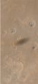
| Xanthe Terra (linke Bildhälfte), neben Margaritifer Terra | ||
| ||
| Position | 3° 0′ N, 48° 0′ W | |
Xanthe Terra (lateinisch für goldgelbes Land; benannt 1979) ist eine große Hochlandregion auf dem Mars.[1]
Beschreibung
Das Gebiet erstreckt sich beiderseits des Äquators, von der Tieflandebene Chryse Planitia im Norden bis zu den Mariner-Tälern im Süden. In seiner weitesten Ausdehnung misst es 2456 km. Kartografisch befindet sich die Region teilweise im Südosten des Lunae Palus-Gradfeldes, im Südwesten des Oxia Palus-Gradfelds, im Nordosten des Coprates-Gradfelds und im Nordwesten des Margaritifer Sinus-Gradfelds.
Bilder der Raumsonden Mars Express, Mars Global Surveyor und des Mars Reconnaissance Orbiters zeigen ehemalige Flusstäler und Deltas. Die Deltas bestehen aus mehreren dünnen Schichten, ähnlich dem Aufbau derer auf der Erde.[2]
Galerie

5-km-Einschlagkrater mit Flussablagerungen der Nanedi Valles
Schatten des Marsmonds Phobos, nördlich der Nanedi Valles

Erdrutsch im Westen von Ganges Chasma
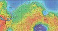
Kartografische Grenzen von Xanthe Terra und anderen Regionen

Weblinks
- Xanthe Terra in google.com/mars (englisch)
- DLR: Regen auf dem Mars? Vor vier Milliarden Jahren bildeten sich in Einschlagkratern Ablagerungen von Seen 24. September 2008
Einzelnachweise
- ↑ Xanthe Terra im Gazetteer of Planetary Nomenclature der IAU (WGPSN) / USGS
- ↑ David M. Nelson, Ronald Greeley: Geology of Xanthe Terra outflow channels and the Mars Pathfinder landing site. In: Journal of Geophysical Research: Planets. Band 104, E4, 25. April 1999, ISSN 2156-2202, S. 8653–8669, doi:10.1029/98JE01900 (wiley.com [abgerufen am 6. Juni 2016]).
Auf dieser Seite verwendete Medien

MOLA map showing boundaries of Arabia and nearby regions

Nanedi Valles, in the Xanthe Highlands on Mars, opens into an impact crater approximately five kilometres across. Channels within the crater show evidence of flowing water in the past. Read more at DLR.de.

Carte de Mars reconstituée à partir des mesures de Mars Global Surveyor (MOLA) et des observations de Viking.

This is a daytime IR image of a chaos region within Xanthe Terra. As with earlier images, the landslide in this image is caused by the failure of steep slopes releasing material to form the landslide deposit.
A Viking 2 orbiter view showing southern parts of Chryse Planitia, eastern parts of Valles Marineris, and several outflow channels in the area.