Wisconsin Range
| Wisconsin Range | ||
|---|---|---|
| Höchster Gipfel | Faure Peak (3940 m) | |
| Lage | Marie-Byrd-Land, Westantarktika | |
| Teil der | Horlick Mountains, Transantarktisches Gebirge | |
| Koordinaten | 85° 45′ S, 125° 0′ W | |
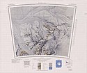
 Topographische Karte von 1968 | ||
Die Wisconsin Range ist ein großer Gebirgszug des Transantarktischen Gebirges im westantarktischen Marie-Byrd-Land, der das Wisconsin-Plateau und diverse Gletscher, Bergrücken und Gipfel umfasst, die vom Reedy-Gletscher, dem Shimizu-Eisstrom, dem Horlick-Eisstrom und dem zentralen Polarplateau begrenzt werden.
Das Gebiet wurde vom United States Geological Survey und mithilfe von Luftaufnahmen der United States Navy aus den Jahren 1959 bis 1964 kartografisch erfasst. Das Advisory Committee on Antarctic Names benannte den Gebirgszug 1962 nach der University of Wisconsin–Madison, die zahlreiche Forscher nach Antarktika entsandte.
Weblinks
- Wisconsin Range auf geographic.org (englisch)
- Wisconsin Range. In: Geographic Names Information System. United States Geological Survey, United States Department of the Interior, archiviert vom (englisch).
- Wisconsin Range auf Peakbagger.com (englisch)
Auf dieser Seite verwendete Medien
Autor/Urheber: Alexrk2, Lizenz: CC BY-SA 3.0
Physische Positionskarte Antarktis, Mittabstandstreue Azimutalprojektion
1:250,000-scale topographic reconnaissance map of the Wisconsin Range area from 120°-135°W to 85°-86°S in Antarctica, including the Ready Glacier. Mapped, edited and published by the U.S. Geological Survey in cooperation with the National Science Foundation.


