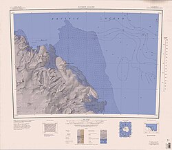
Williamson Head
| Williamson Head | ||
 Williamson Head (links oben) | ||
| Geographische Lage | ||
| Koordinaten | 69° 11′ S, 158° 0′ O | |
| Lage | Viktorialand, Ostantarktika | |
| Küste | Oates-Küste | |
| Gewässer | Somow-See | |
Das Williamson Head ist eine markante Landspitze an der Oates-Küste im Norden des ostantarktischen Viktorialands. Sie ragt dort 10 km westnordwestlich des Drake Head in die Somow-See hinein.
Das Kap wurde im Februar 1911 von der Besatzung der Terra Nova während der gleichnamigen Antarktisexpedition (1910–1913) unter der Leitung des britischen Polarforschers Robert Falcon Scott entdeckt und benannt. Namensgeber ist Thomas Soulsby Williamson (1877–1940), ein Teilnehmer dieser Forschungsreise.
Weblinks
- Williamson Head. In: Geographic Names Information System. United States Geological Survey, United States Department of the Interior, archiviert vom (englisch).
- Williamson Head auf geographic.org (englisch)
Auf dieser Seite verwendete Medien
Autor/Urheber: Alexrk2, Lizenz: CC BY-SA 3.0
Physische Positionskarte Antarktis, Mittabstandstreue Azimutalprojektion
1:250,000-scale topographic reconnaissance map of the Suvorov Glacier area from 158°-162°E to 69°-70°S in Antarctica. Mapped, edited and published by the U.S. Geological Survey in cooperation with the National Science Foundation.


