Wicklow Way
| Wicklow Way Slí Cualann Nua | |
|---|---|
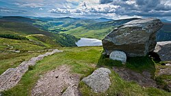
 Das J. B. Malone memorial am Wicklow Way mit Blick über Lough Tay | |
| Daten | |
| Länge | 132 km |
| Lage | Östliches Irland |
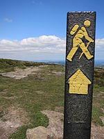
| Markierungszeichen |  |
| Startpunkt | Marlay Park, Dublin 53° 16′ 38,7″ N, 6° 16′ 6,3″ W |
| Zielpunkt | Clonegal 52° 41′ 43,2″ N, 6° 38′ 54,3″ W |
| Typ | Fernwanderweg |
| Höchster Punkt | White Hill (630 m) |
| Niedrigster Punkt | Clonegal (60 m) |
| Schwierigkeitsgrad | anspruchsvoll |
| Jahreszeit | ganzjährig |
| Besonderheiten | Wicklow Mountains, Glendalough |
Der Wicklow Way (irisch Slí Cualann Nua) ist ein 132 km langer Fernwanderweg in Irland, der die Städte Dublin und Clonegal verbindet.[1]
Beschreibung
Der nördliche Abschnitt in den Wicklow Mountains erstreckt sich von Dublin bis nach Aughavannagh und ist geprägt von großen und abgeflachten Gipfeln mit einer Reihe von tiefen Tälern und einer Mischung aus Laub- und Nadelwäldern sowie Heide- und Flächenmooren. Die Wicklow Mountains laufen im südlichen Teil der Route sanft aus und bieten in zahlreichen Hecken vielen Tieren Unterschlupf. Der Wicklow Way folgt Waldwegen, Bergpfaden und ruhigen Landstraßen und führt auch durch die Klostersiedlung Glendalough, welche im 6. Jahrhundert von Kevin von Glendalough gegründet wurde.[1]
Etappen
Nachfolgend eine beispielhafte Streckenaufteilung:[1]
| Startpunkt | Endpunkt | Strecke | Höhenunterschied | Gehzeit | |
|---|---|---|---|---|---|
| Etappe 1 | Marlay Park, Dublin | Glencullen | 10 km | ± 430 m | 3,5 h |
| Etappe 2 | Glencullen | Glencree | 12 km | ± 290 m | 3,5 h |
| Etappe 3 | Glencree | Lough Tay | 12 km | ± 450 m | 4 h |
| Etappe 4 | Lough Tay | Oldbridge | 6 km | ± 90 m | 1,5 h |
| Etappe 5 | Oldbridge | Glendalough | 10 km | ± 350 m | 3,5 h |
| Etappe 6 | Glendalough | Glenmalure | 13 km | ± 460 m | 4,5 h |
| Etappe 7 | Glenmalure | Aughavannagh | 12 km | ± 390 m | 4 h |
| Etappe 8 | Aughavannagh | Moyne | 10 km | ± 230 m | 3 h |
| Etappe 9 | Moyne | Tinahely | 11 km | ± 250 m | 3 h |
| Etappe 10 | Tinahely | Boley | 12 km | ± 270 m | 3 h |
| Etappe 11 | Boley | Clonegal | 20 km | ± 380 m | 6 h |
Der Wicklow Way kann bei Kombination mehrerer Etappen bequem in fünf bis sieben Tagen begangen werden.
Impressionen
- Startpunkt im Marlay Park, Dublin
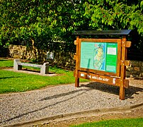
- Endpunkt in Clonegal
- Der Wicklow Way nahe Curtlestown
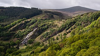
- Powerscourt Deerpark und Powerscourt Waterfall mit Djouce Mountain im Hintergrund
- (c) sarah gallagher, CC BY-SA 2.0Am White Hill
- Klostersiedlung in Glendalough
- Blick in das Glendalough
Einzelnachweise
Weblinks
Auf dieser Seite verwendete Medien
(c) OOjs UI Team and other contributors, MIT
An icon from the OOjs UI MediaWiki lib.
(c) sarah gallagher, CC BY-SA 2.0
The Wicklow way from Djouce Mountain Djouce (Irish: Dioghais, meaning fortified height), sometimes referred to as Djouce Mountain, is a mountain situated in the northeastern section of the Wicklow Mountains. To the west it overlooks the highlands around the Sally Gap; to the east the Roundwood / Calary Bog plateau.
Autor/Urheber: Joe King, Lizenz: CC BY-SA 3.0
The trailhead of the Wicklow Way in Marlay Park, County Dublin, Ireland. The Wicklow Way is a 132km long-distance National Waymarked Trail that runs from Marlay Park across County Wicklow and ends at Clonegal in County Carlow. The trailhead is denoted by a map board (not shown) and a low stone wall with a stile through which walkers pass to make their first step on the Wicklow Way. The wall was erected in 2006 as part of a series of works to mark the 25th anniversary of the opening of the Way.
Autor/Urheber: Billstein~dewikivoyage, Lizenz: CC BY-SA 4.0
Wegzeichen des Wicklow Way
Autor/Urheber: Joe King, Lizenz: CC BY-SA 3.0
Crossing the Glendasan River near the Monastic City of Glendalough, County Wicklow, Ireland
Photo of the upper lake and valley in Glendalough, Co. Wicklow.
Autor/Urheber: Joe King, Lizenz: CC BY-SA 3.0
A waymarker on the Wicklow Way National Waymarked Trail near Curtlestown Wood, County Wicklow Ireland overlooking the Glencree valley with the mountains Maulin, Djouce and War Hill in the distance.
Autor/Urheber: Joe King, Lizenz: CC BY-SA 3.0
View of Powerscourt Deerpark and Waterfall at Ride Rock, Crone Woods near Enniskerry, County Wicklow, Ireland. At 121 metres, the waterfall is the tallest in Ireland. It is fed by the River Dargle which rises in the Glensoulan valley near Djouce mountain, which can be seen in background.
Autor/Urheber: Joe King, Lizenz: CC BY-SA 3.0
The trailhead of the Wicklow Way in Clonegal, County Carlow, Ireland. The Wicklow Way is a 132km long-distance National Waymarked Trail that runs from Marlay Park in County Dublin across County Wicklow and ends at Clonegal in County Carlow. The trailhead is denoted by a map board and a stone bench. The bench was erected in 2006 as part of a series of works to mark the 25th anniversary of the opening of the Way.
Autor/Urheber: Joe King, Lizenz: CC BY-SA 3.0
The J. B. Malone memorial overlooking Lough Tay in the Wicklow Mountains National Park on the Wicklow Way walking trail, County Wicklow, Ireland


