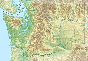
Wenatchee National Forest
Wenatchee National Forest IUCN-Kategorie VI – Protected Area with Sustainable use of Natural Resources | ||
Bumping River, Wenatchee National Forest | ||
| Lage | Washington, USA | |
| Fläche | 7022,89 km²[1] | |
| Geographische Lage | 48° 23′ N, 121° 0′ W | |
| Einrichtungsdatum | 1. Juli 1908[2] | |
| Verwaltung | U.S. Forest Service | |
Der Wenatchee National Forest ist ein National Forest in Washington im Nordwesten der USA. Auf einer Fläche von 7022,89 Quadratkilometern erstreckt er sich über etwa 220 Kilometer entlang des Ostabhangs des Kaskadengebirges zwischen dem Okanogan National Forest und dem Gifford Pinchot National Forest. Das Waldgebiet befindet sich in den Countys Chelan, Kittitas und Yakima. Die nächstgelegene Stadt ist Wenatchee, WA.
Wildnis-Gebiete
Es gibt im Wenatchee National Forest sechs offiziell benannte Wildnisgebiete, die Teil des National Wilderness Preservation Systems der USA sind. Alle liegen teilweise auch in benachbarten National Forests:
- Alpine Lakes Wilderness (teilweise im Snoqualmie National Forest)
- Glacier Peak Wilderness (teilweise im Mount Baker National Forest)
- Goat Rocks Wilderness (hauptsächlich im Gifford Pinchot National Forest)
- Henry M. Jackson Wilderness (teilweise im Snoqualmie National Forest (46,2 Prozent) und im Mount Baker National Forest (27,2 Prozent))
- Lake Chelan-Sawtooth Wilderness (hauptsächlich im Okanogan National Forest)
- William O. Douglas Wilderness (teilweise im Gifford Pinchot NF)
Waptus Lake
Nahezu zwei Meilen (3,2 Kilometer) lang und nur über Wanderwege oder Reitpfade zu erreichen, ist der Waptus Lake der größte alpine See im National Forest. Er wird vom Waptus River entwässert. Bemerkenswert sind die Sichten auf die Gipfel des Summit Chief und der Bears Breast.
Verwaltung
Der Okanogan und der Wenatchee National Forest werden gemeinsam als Okanogan-Wenatchee National Forest im Hauptquartier in Wenatchee (Washington) verwaltet. Es gibt örtliche Ranger-Distrikte in Chelan, Cle Elum, Entiat, Methow Valley, Naches, Tonasket und Wenatchee River. Der erste Leiter des Wenatchee National Forest war Albert H. Sylvester, der mehr als tausend Örtlichkeiten in der Region benannte.
Ökologie
Eine Studie des U. S. Forest Service von 1993 schätzte den Bestand von Urwald im Forest auf etwa 1290 Quadratkilometer (318.800 Acre).[3] Waldbrände sind im National Forest nichts ungewöhnliches. Im September 2012 verursachte ein schweres Gewitter hunderte von Waldbränden, die schwersten von ihnen südwestlich von Wenatchee und östlich des Blewett Pass. Auch im Juli 2014 wurden heftige Waldbrände in den Chiwaukum und den Entiat Mountains ausgelöst.[4]
Einzelnachweise
- ↑ Land Areas of the National Forest System. U.S. Forest Service, Januar 2012, abgerufen am 30. Juni 2012.
- ↑ The National Forests of the United States. (Nicht mehr online verfügbar.) ForestHistory.org, ehemals im Original; abgerufen am 30. Juli 2012. (Seite nicht mehr abrufbar. Suche in Webarchiven.) Info: Der Link wurde automatisch als defekt markiert. Bitte prüfe den Link gemäß Anleitung und entferne dann diesen Hinweis.
- ↑ Charles L. Bolsinger, Karen L. Waddell: Area of old-growth forests in California, Oregon, and Washington. In: Resource Bulletin PNW-RB-197. United States Forest Service, Pacific Northwest Research Station, 1993 (englisch, fed.us [PDF]).
- ↑ Lynda V. Mapes: Collateral Damage: Rushing to stop a fire that never came, Forest Service logged miles of big trees, critical habitat. In: Seattle Times, 23. Juli 2015. Abgerufen am 23. Juli 2016.
Weblinks
- Okanogan-Wenatchee National Forest – Offizielle Website des U.S. Forest Service
Auf dieser Seite verwendete Medien
Autor/Urheber: Walter Siegmund (talk), Lizenz: CC BY-SA 3.0
Diese Grafik wurde mit Hugin erstellt.
Autor/Urheber: Sprague, Lizenz: CC BY-SA 4.0
A view from the western shore of Lake Waptus.
The Bumping River is a tributary of the Naches River, in Washington in the United States. It flows down the east side of the Cascade Range, through riparian forests in the Wenatchee National Forest and the William O. Douglas Wilderness. From its source at Fish Lake near Crag Mountain, it flows northeast to Bumping Lake, a natural lake enlarged and regulated by Bumping Lake Dam. Below the dam, the Bumping River continues flowing northeast. It is joined by the American River, its main tributary, a few miles above its mouth where it joins the Little Naches River to form the Naches River.
Autor/Urheber: Carport, Lizenz: CC BY-SA 3.0
Physische Positionskarte von Washington, USA


