Wat’s Dyke
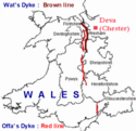
Wat’s Dyke ist ein über 60 km langer Wall in der walisisch-englischen Grenzregion Welsh Marches. Der Wall verläuft unter anderem an Oswestry vorbei.
Historiker einigten sich auf das 8. Jahrhundert als Entstehungszeitraum, doch verweisen C14-Messungen auf das 5. Jahrhundert.
Literatur
- H. R. Hannaford: Archaeological on Wat’s Dyke at Maes-y-Clawdd. In: Archaeology Service, Shropshire County Council. Report 132, Dezember 1997.
- Margaret Worthington: Wat’s Dyke: An Archaeological and Historical Enigma. In: Bulletin John Rylands Library, Manchester. Band 79, Nr. 3, 1997.
Koordinaten: 52° 59′ 12″ N, 3° 1′ 43″ W
Auf dieser Seite verwendete Medien
(c) Peter Craine, CC BY-SA 2.0
Wat's Dyke near Northop. Although the dyke at this point is not very impressive visually, it must have taken a lot of work to make it. For more info see Wat's Dyke
I have done a map of Wales with my software and added data about Wat's Dyke and Offa's Dyke.


