Warrick County
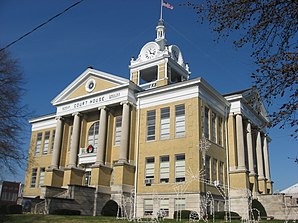
 Warrick County Counrthouse | |
| Verwaltung | |
|---|---|
| US-Bundesstaat: | Indiana |
| Verwaltungssitz: | Boonville |
| Adresse des Verwaltungssitzes: | County Courthouse 109 W. Main Street Boonville, IN 47601-1513 |
| Gründung: | 9. März 1813 |
| Gebildet aus: | Knox County |
| Vorwahl: | 001 812 |
| Demographie | |
| Einwohner: | 63.898 (Stand: 2020) |
| Bevölkerungsdichte: | 64,28 Einwohner/km2 |
| Geographie | |
| Fläche gesamt: | 1012 km² |
| Wasserfläche: | 18 km² |
| Karte | |
 | |
| Website: www.warrickcounty.gov | |
Das Warrick County[1] ist ein County im US-Bundesstaat Indiana. Der Verwaltungssitz (County Seat) ist Boonville.[2]
Geographie
Das County liegt im Südwesten von Indiana am Ohio River, der die Grenze zu Kentucky bildet. Es hat eine Fläche von 1012 Quadratkilometern, wovon 18 Quadratkilometer Wasserfläche sind. An das Warrick County grenzen folgende Countys:
| Gibson County | Pike County | Dubois County |
| Vanderburgh County |  | Spencer County |
| Henderson County (Kentucky) | Daviess County (Kentucky) |
Geschichte
Das Warrick County wurde am 9. März 1813 aus Teilen des Knox County gebildet. Benannt wurde es nach Jacob Warrick (1773–1811), einem Offizier, der in der Schlacht bei Tippecanoe fiel.
7 Bauwerke und Stätten des Countys sind im National Register of Historic Places eingetragen (Stand 5. September 2017).[3]
Demografische Daten
| Bevölkerungswachstum | |||
|---|---|---|---|
| Census | Einwohner | ± rel. | |
| 1820 | 1.749 | — | |
| 1830 | 2.877 | 64,5 % | |
| 1840 | 6.321 | 119,7 % | |
| 1850 | 8.811 | 39,4 % | |
| 1860 | 13.261 | 50,5 % | |
| 1870 | 17.653 | 33,1 % | |
| 1880 | 20.162 | 14,2 % | |
| 1890 | 21.161 | 5 % | |
| 1900 | 22.329 | 5,5 % | |
| 1910 | 21.911 | −1,9 % | |
| 1920 | 19.862 | −9,4 % | |
| 1930 | 18.230 | −8,2 % | |
| 1940 | 19.435 | 6,6 % | |
| 1950 | 21.527 | 10,8 % | |
| 1960 | 23.577 | 9,5 % | |
| 1970 | 27.972 | 18,6 % | |
| 1980 | 41.474 | 48,3 % | |
| 1990 | 44.920 | 8,3 % | |
| 2000 | 52.383 | 16,6 % | |
| 2010 | 59.689 | 13,9 % | |
| 2020 | 63.898 | 7,1 % | |
| Vor 1900[4] 1900–1990[5] 2000 + 2010[6] | |||


Nach der Volkszählung im Jahr 2010 lebten im Warrick County 59.689 Menschen in 22.223 Haushalten. Die Bevölkerungsdichte betrug 52,7 Einwohner pro Quadratkilometer.
Ethnisch betrachtet setzte sich die Bevölkerung zusammen aus 95,0 Prozent Weißen, 1,3 Prozent Afroamerikanern, 0,2 Prozent amerikanischen Ureinwohnern, 1,6 Prozent Asiaten sowie aus anderen ethnischen Gruppen; 1,3 Prozent stammten von zwei oder mehr Ethnien ab. Unabhängig von der ethnischen Zugehörigkeit waren 1,6 Prozent der Bevölkerung spanischer oder lateinamerikanischer Abstammung.
In den 22.223 Haushalten lebten statistisch je 2,53 Personen.
25,9 Prozent der Bevölkerung waren unter 18 Jahre alt, 60,8 Prozent waren zwischen 18 und 64 und 13,3 Prozent waren 65 Jahre oder älter. 50,7 Prozent der Bevölkerung war weiblich.
Das jährliche Durchschnittseinkommen eines Haushalts lag bei 58.436 USD. Das Prokopfeinkommen betrug 29.237 USD. 8,0 Prozent der Einwohner lebten unterhalb der Armutsgrenze.[9]
Orte im Warrick County
- Boonville
|
|
- weitere Orte
- Ash Iron Springs
- Baugh City
- Bullocktown
- Camp Brosend
- Center
- Dayville
- De Gonia Springs
- Dickeyville
- Eames
- Eby
- Fisherville
- Folsomville
- Graham Valley
- Greenbrier
- Heilman
- Hemenway
- Hillcrest Terrace
- Jockey
- Loafers Station
- Millersburg
- New Hope
- Paradise
- Pelzer
- Red Bush
- Rolling Acres
- Rustic Hills
- Scalesville
- Selvin
- Stanley
- Stevenson
- Turpin Hill
- Vanada
- Wheatonville
- Yankeetown
- Anderson Township
- Boon Township
- Campbell Township
- Greer Township
- Hart Township
- Lane Township
- Ohio Township
- Owen Township
- Pigeon Township
- Skelton Township
Einzelnachweise
- ↑ GNIS-ID: 450335. Abgerufen am 22. Februar 2011 (englisch).
- ↑ National Association of Counties Abgerufen am 21. November 2011
- ↑ Suchmaske Datenbank im National Register Information System. National Park Service, abgerufen am 5. September 2017.
- ↑ U.S. Census Bureau - Census of Population and Housing Abgerufen am 15. März 2011
- ↑ Auszug aus Census.gov. Abgerufen am 16. Februar 2011
- ↑ Auszug aus census.gov (2000+2010) Abgerufen am 2. April 2012
- ↑ Auszug aus dem National Register of Historic Places - Nr. 79000025 Abgerufen am 21. November 2011
- ↑ Auszug aus dem National Register of Historic Places - Nr. 78000040 Abgerufen am 21. November 2011
- ↑ U.S. Census Buero, State & County QuickFacts - Warrick County Abgerufen am 21. November 2011
Weblinks
- U.S. Census Buero, State & County QuickFacts - Warrick County
- Yahoo Bildersuche - Warrick County
- www.city-data.com - Warrick County
Koordinaten: 38° 6′ N, 87° 16′ W
Auf dieser Seite verwendete Medien
Southern and eastern sides of the Warrick County Courthouse, located on Courthouse Square in Boonville, Indiana, United States. Built in 1904, it is part of the Boonville Public Square Historic District. Please note that the time given by EXIF is wrong: the camera was still set for daylight savings time, rather than standard time, and I forgot to adjust for the fact that Warrick County is on Central Time rather than Eastern Time. This photograph was taken at 11:16 AM local time.
Front of the Old Warrick County Jail, located at 124 E. Main Street (State Road 62) in in Boonville, Indiana, United States. Built in 1877, it is listed on the National Register of Historic Places, and it is part of a Register-listed historic district, the Boonville Public Square Historic District. Please note that the time given by EXIF is wrong: the camera was still set for daylight savings time, rather than standard time, and I forgot to adjust for the fact that Warrick County is on Central Time rather than Eastern Time. This photograph was taken at 11:14 AM local time.
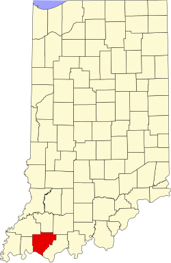
This is a locator map showing Warrick County in Indiana. For more information, see Commons:United States county locator maps.
Front and southern side of the Old Newburgh Presbyterian Church, located on the northwestern corner of the junction of State and Main Streets in downtown Newburgh, Indiana, United States. Built in 1851 for a congregation of the Cumberland Presbyterian Church, it is now Newburgh's town hall, and it is listed on the National Register of Historic Places.


