Vispertal
| Vispertal (Vallée de Viège) | ||
|---|---|---|
 Blick talauswärts auf das Vispertal, gegenüber die Berner Alpen mit dem markanten Bietschhorn (links). Häusergruppe links nördlicher Teil von Stalden. Bildmitte Ackersand, Haus rechts Staldenried | ||
| Lage | Kanton Wallis | |
| Gewässer | Vispa | |
| Gebirge | Walliser Alpen | |
| Geographische Lage | 633962 / 124000 | |
| Topo-Karte | Landeskarte der Schweiz 1:25.000 (LK25), Blatt 1288, Raron | |
| ||
| Typ | U-Tal | |
| Höhe | 645 bis 2876 m ü. M. | |
| Länge | 7,5 km | |
| Klima | Ackersand ist der trockenste Ort der Schweiz | |
| Flora | Höchstgelegener Rebberg nördlich des Alpenhauptkammes | |
| Nutzung | Winter- und Sommertourismus, Land- und Alpwirtschaft, Wasserkraft | |
| Besonderheiten | Verzweigt sich bei Stalden ins Mattertal und Saastal | |
Das Vispertal ist ein rund 7,5 Kilometer langes Seitental des Schweizer Rhonetals. Unter dem Begriff Vispertäler versteht man hingegen das ganze Einzugsgebiet des Flusses Vispa, also das Vispertal zusammen mit dem Mattertal und dem Saastal.
Geographie
_(14576904889).jpg)
Das Vispertal beginnt beim Zusammenfluss des Mattertals und des Saastals bei Stalden und endet bei Visp. Durchflossen wird das Tal von der Vispa, einem Nebenfluss des Rotten bzw. der Rhone, die sich bei Stalden durch den Zusammenfluss der Mattervispa und der Saaservispa bildet.
Gemeinden
Die zum Vispertal gehörenden Munizipalgemeinden (von oben abwärts – also Süd nach Nord) sind gemäss Geographischem Lexikon der Schweiz:[1]
Die Ortskerne von Stalden (795 m) und Zeneggen (1370 m) liegen an der linken Talflanke des Vispertals, Staldenried (1052 m) und Visperterminen (1378 m) an der rechten Talflanke und Visp (658 m) am Talboden.
Bilder
 Visp in der Ebene des Rhonetals, im Hintergrund das Vispertal.
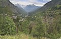 Blick talauswärts gegen Norden auf das Vispertal, gegenüber die Berner Alpen. Häusergruppe links nördlicher Teil von Stalden, Bildmitte Ackersand und rechts Staldenried.
 Törbel oberhalb des Vispertals (rechts) und des Mattertals (links)
 Saas- und Vispertal.
 Blick vom Matterhorn auf Mattertal (links) mit Mischabel auf der Ostseite, Monte Rosa (Bildmitte) und Valtournenche (rechts).
Weblinks
- Rundblick March / Violenhorn (2876 m)
- Gesichter der Schweiz: die Vispertäler (eine geografische Bildpräsentation)
- Rundtour Vispertal
- Vispertal auf der Plattform ETHorama
Einzelnachweise
- ↑ Geographisches Lexikon der Schweiz. Band 6: Tavetsch – Zybachsplatte. Supplement. Attinger, Neuenburg 1910, S. 413.
Auf dieser Seite verwendete Medien

Autor/Urheber: Rafał Raczyński , Lizenz: CC BY-SA 3.0
View from the summit of the Matterhorn. Zermatt in valley Mattertal, Gornergrat and a view to Monte Rosa massif.


Autor/Urheber: Rene.kernen, Lizenz: CC BY-SA 3.0
Visp in der Ebene des Rhonetals, im Hintergrund das Vispertal.
Vispertal von Stalden talauswärts gegen die Berner Alpen mit dem Bietschhorn (links).
Autor/Urheber: Internet Archive Book Images, Lizenz: No restrictions
Identifier: 02491087.5441.emory.edu
Title: Switzerland: and the adjacent portions of Italy, Savoy, and Tyrol : handbook for travellers
Year: 1905 (1900s)
Authors: Karl Baedeker (Firm)
Subjects:
Publisher: Leipzig : K. Baedeker London : Dulau and Co. New York : C. Scribner's Sons
Contributing Library: Emory University, Manuscript, Archives and Rare Book Library
Digitizing Sponsor: Emory University, Manuscript, Archives and Rare Book Library
View Book Page: Book Viewer
About This Book: Catalog Entry
View All Images: All Images From Book
Click here to view book online to see this illustration in context in a browseable online version of this book.
Text Appearing Before Image:
nteresting. — The Barrjoch (11,990), Brunnegg-Joch (11,100), and Biesjoch (11,644; difficult) are glacier-passes, fit forexperts only, with able guides (40 fr.). 84. From Visp to Zermatt. 221/2 M. Railway in 2/4-2i/2 hrs. (2nd cl. 16, 3rd cl. 10 fr., return-tickets 28 fr. 80 c. and 18 fr.) — The railway from Visp to Zermatt com-bines the ordinary and rack-and-pinion .systems, and is worked by engineson Abts system. Maximum gradient on the ordinary sections, 45:1000;on the rack-and-pinion sections 125: 1000. Best views to the left. On Foot: from Visp to Zermatt 91/2 hrs. (Stalden 2 hrs., St. Niklaus3 hrs., Randa 6V2 M., Tasch 2/2 M., Zermatt 3/s M.). Bridle-path to St.Niklaus, carriage-road thence to Zermatt (one-horse carr. 15, two-horse25 fr.). — The route from Visp to Zermatt, with its picturesque rock-scenery and waterfalls, is easy and attractive. Visp (2160), see p. 352. The Tailway makes a wide bend, to theS., towards the rapid and turbid Vim. and eradnallv nsf.pnds on the
Text Appearing After Image:
ST. NIKLAUS. V. Route 84. 377 right bank of the stream. The train passes under the Neubriicke(2280), crosses the river by an iron bridge, 40 yds. long, and ascends(rack-and-pinion section, 1050 yds. long) to (5 M.) Stalden (2635;*Hot. Stalden, R. iy2-3, B. li/2, D. 4, pens. 5-8 fr.; Pens.-Restaur.Burgener, well spoken of; Cafe near the church, good), a pleasantvillage situated in a very fertile region, on a mountain-spur, at thefoot of which the Saaser Visp and the Matter Visp unite. The valleydivides. To-the S., between the Nicolai and Saas valleys, rises thesnow-pyramid of the Balfrinhom (12,475)- The culture of the vineextends 2 M. beyond Stalden. From Stalden to (4V2hrs.) Saas-Fee, see p. 387. To the Simplon ovek the Bistenen Pass, 9-10 hrs., repaying (gaide15 fr.; Joh. Fierrer of Stalden; horse 30 fr.). Bridle-path from Vispor Stalden past the highest vineyards of Switzerland (Heidenwein) toC2 hrs.) Visperlerminen (4395; Hot.-Pens. Gebiidem-Alpe, pens. 5-6 fr.), avillage finely s
Note About Images

Autor/Urheber: Wandervogel, Lizenz: CC BY-SA 3.0
Blick von Grächen auf Törbel mit Strasse von Stalden.

Autor/Urheber: Ximonic, Simo Räsänen, Lizenz: CC BY-SA 3.0
A view to Vispertal towards north in 2010 July.

Autor/Urheber: Ximonic, Simo Räsänen, Lizenz: CC BY-SA 3.0
A view to Saastal and Vispertal further to the north in 2010 July.