Villaviciosa (Abra)
| Municipality of Villaviciosa | ||
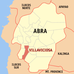
| Lage von Villaviciosa in der Provinz Abra | ||
|---|---|---|
 | ||
| Basisdaten | ||
| Region: | Regierungsbezirk Cordillera | |
| Provinz: | Abra | |
| Barangays: | 8 | |
| Distrikt: | 1. Distrikt von Abra | |
| PSGC: | 140127000 | |
| Einkommensklasse: | 5. Einkommensklasse | |
| Haushalte: | 930 Zensus 1. Mai 2000 | |
| Einwohnerzahl: | 5.392 Zensus 1. August 2015 | |
| Einwohnerdichte: | 62 Einw. je km² | |
| Fläche: | 87 km² | |
| Koordinaten: | 17° 26′ N, 120° 38′ O | |
| Postleitzahl: | 2811 | |
| Geographische Lage auf den Philippinen | ||
| ||
Villaviciosa ist eine philippinische Stadtgemeinde in der Provinz Abra. Sie hat 5392 Einwohner (Zensus 2015).
Baranggays
Villaviciosa ist politisch unterteilt in acht Baranggays.
|
|
|
Auf dieser Seite verwendete Medien
(c) Karte: NordNordWest, Lizenz: Creative Commons by-sa-3.0 de
Positionskarte der Philippinen
Autor/Urheber: Mike Gonzalez (TheCoffee), Lizenz: CC BY-SA 3.0
Map of Abra showing the location of Villaviciosa


