Villaines-sous-Malicorne
| Villaines-sous-Malicorne | ||
|---|---|---|
| ||
| Staat | Frankreich | |
| Region | Pays de la Loire | |
| Département (Nr.) | Sarthe (72) | |
| Arrondissement | La Flèche | |
| Kanton | La Flèche | |
| Gemeindeverband | Pays Fléchois | |
| Koordinaten | 47° 46′ N, 0° 6′ W | |
| Höhe | 40–94 m | |
| Fläche | 19,16 km² | |
| Einwohner | 1.034 (1. Januar 2020) | |
| Bevölkerungsdichte | 54 Einw./km² | |
| Postleitzahl | 72270 | |
| INSEE-Code | 72377 | |
 Rathaus (Mairie) von Villaines-sous-Malicorne | ||
Villaines-sous-Malicorne ist eine französische Gemeinde mit 1.034 Einwohnern (Stand: 1. Januar 2020) im Département Sarthe in der Region Pays de la Loire. Sie gehört zum Arrondissement La Flèche und zum Kanton La Flèche (bis 2015: Kanton Malicorne-sur-Sarthe). Die Einwohner werden Villainais genannt.
Geographie
Villaines-sous-Malicorne liegt etwa 32 Kilometer südwestlich von Le Mans. Umgeben wird Villaines-sous-Malicorne von den Nachbargemeinden Arthezé im Norden, Bousse im Osten, La Flèche im Süden, Crosmières im Westen und Südwesten sowie Le Bailleul im Westen.
Bevölkerungsentwicklung
| 1962 | 1968 | 1975 | 1982 | 1990 | 1999 | 2006 | 2017 |
|---|---|---|---|---|---|---|---|
| 747 | 745 | 796 | 730 | 725 | 746 | 936 | 1025 |
| Quellen: Cassini und INSEE | |||||||
Sehenswürdigkeiten
- Kirche Saint-Germain aus dem 11./12. Jahrhundert, Monument historique
- Kapelle L’Aubinière
- Reste einer Turmhügelburg bei La Roche-Simon
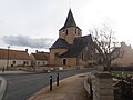
Kirche Saint-Germain

Kapelle L’Aubinière
Weblinks
Commons: Villaines-sous-Malicorne – Sammlung von Bildern, Videos und Audiodateien
Auf dieser Seite verwendete Medien

France adm-2 location map.svg
(c) Karte: NordNordWest, Lizenz: Creative Commons by-sa-3.0 de
Positionskarte von Frankreich mit Regionen und Départements
(c) Karte: NordNordWest, Lizenz: Creative Commons by-sa-3.0 de
Positionskarte von Frankreich mit Regionen und Départements
Mairie de Villaines-sous-Malicorne 23 mars 018.jpg
Autor/Urheber: Labiloute, Lizenz: CC BY-SA 3.0
La mairie de Villaines-sous-Malicorne, Sarthe, France
Autor/Urheber: Labiloute, Lizenz: CC BY-SA 3.0
La mairie de Villaines-sous-Malicorne, Sarthe, France

23 mars 021.JPG
Autor/Urheber: Labiloute, Lizenz: CC BY-SA 3.0
L'église vue de la place de la mairie
Autor/Urheber: Labiloute, Lizenz: CC BY-SA 3.0
L'église vue de la place de la mairie

Villaines-sous-Mailcone - Chapelle de L'aubinière.JPG
Autor/Urheber: Gregofhuest, Lizenz: CC BY-SA 4.0
Chapelle de l'Aubinière - Villaines-sous-Malicorne - Sarthe (72)
Autor/Urheber: Gregofhuest, Lizenz: CC BY-SA 4.0
Chapelle de l'Aubinière - Villaines-sous-Malicorne - Sarthe (72)