Victoria Valley (Antarktika)
| Victoria Valley | ||
|---|---|---|
| Lage | Viktorialand, Ostantarktika | |
| Gewässer | Lake Vida | |
| Gebirge | Transantarktisches Gebirge | |
| Geographische Lage | 77° 23′ 0″ S, 162° 0′ 0″ O | |
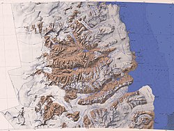
Das Victoria Valley ist ein ausgedehntes, eisfreies Trogtal im ostantarktischen Viktorialand. Es erstreckt sich vom Oberen Victoria-Gletscher bis zum Unteren Victoria-Gletscher, liegt nördlich des Wright Valley und etwa parallel zu diesem.
Benannt wurde es anlässlich der von 1958 bis 1959 durchgeführten Kampagne im Rahmen der Victoria University’s Antarctic Expeditions nach der Alma Mater der Victoria University of Wellington, welche die Expedition finanziell unterstützt hatte.
Im Victoria Valley liegt der hypersaline See Lake Vida.
Weblinks
- Victoria Valley im Geographic Names Information System des United States Geological Survey (englisch)
- Victoria Valley auf geographic.org (englisch)
Auf dieser Seite verwendete Medien
Autor/Urheber: Alexrk2, Lizenz: CC BY-SA 3.0
Physische Positionskarte Antarktis, Mittabstandstreue Azimutalprojektion
Victoria Upper Glacier in Victoria Valley
Map of the McMurdo Dry Valleys merged from two 1:250,000-scale topographic reconnaissance maps published by the U.S. Geological Survey in cooperation with the National Science Foundation, both compiled in 1962 (the western half revised in 1988, the eastern half in 1970). It comprises the area from 77° to 78° South and approximately 158° to 165° East


