Verwaltungsgliederung Nepals bis 2015
Bis zur Gründung von Provinzen durch die Verfassung von 2015 bestand die Verwaltungsgliederung Nepals aus fünf Entwicklungsregionen (Nepali: विकास क्षेत्र, bikās kshetra), 14 Verwaltungszonen (Nepali: अञ्चल, añchal) und 75 Distrikten (Nepali: जिल्ला, jillā)[1]. Die Distrikte bestanden wiederum aus über 3000 Village Development Committees (VDC) (Nepali: गाउँ बिकास समिति, Gāu Bikās Samiti) sowie 217 Städten (Nepali: नगरपालिका, nagarpālikā) (municipalities), wobei es unter den Städten, je nach Größe, drei Differenzierungen gab.[2] Die meisten Städte Nepals haben Stadtrecht 3. Ordnung (Nepali: नगरपालिका, nagarpālikā), Pokhara, Lalitpur, Biratnagar, Bharatpur, Birganj, Butwal, Janakpur, Dharan und Dhangadhi haben Stadtrecht 2. Ordnung (Nepali: उपमहानगरपालिका, upmahānagarpālikā) und einzig Kathmandu hat Stadtrecht 1. Ordnung (Nepali: महानगरपालिका, mahānagarpālikā).[3][4]
Die neue Verfassung sieht die Aufteilung des Landes in sieben Provinzen vor, die die Rolle der Bundesstaaten innerhalb der föderalen Republik einnehmen.
Die Angaben in Klammern auf der folgenden Liste beziehen sich auf die nebenstehende Übersichtskarte.
Entwicklungsregion Ost
Die Entwicklungsregion Ost (Nepali: पुर्वाञ्चल विकास क्षेत्र Purbānchal Bikās Kshetra / Entwicklungsregion der östlichen Zonen) (Englisch: Eastern Development Region) bestand aus den Zonen Mechi, Koshi und Sagarmatha.
Distrikte der Zone Mechi:
Distrikte der Zone Koshi:
Distrikte der Zone Sagarmatha:
- Khotang (37)
- Okhaldhunga (49)
- Saptari (63)
- Siraha (67)
- Solukhumbu (68)
- Udayapur (75)
Entwicklungsregion Mitte
Die Entwicklungsregion Mitte (Nepali: मध्यमाञ्चल विकास क्षेत्र Madyamānchal Bikās Kshetra / Entwicklungsregion der Mittleren Zonen) (Englisch: Central Development Region) bestand aus den Zonen Janakpur, Bagmati und Narayani.
Distrikte der Zone Janakpur:
Distrikte der Zone Bagmati:
- Bhaktapur (10)
- Dhading (17)
- Kathmandu (35)
- Kabhrepalanchok (36)
- Lalitpur (38)
- Nuwakot (48)
- Rasuwa (56)
- Sindhupalchok (66)
Distrikte der Zone Narayani:
Entwicklungsregion West
Die Entwicklungsregion West (Nepali: पश्चिमाञ्चल विकास क्षेत्र Pashchimānchal Bikās Kshetra / Entwicklungsregion der Westlichen Zonen) (Englisch: Western Development Region) bestand aus den Zonen Gandaki, Lumbini und Dhaulagiri.
Distrikte der Zone Gandaki:
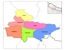
Distrikte der Zone Lumbini:
- Arghakhanchi (2)
- Gulmi (24)
- Kapilbastu (33)
- Nawalparasi (47)
- Palpa (50)
- Rupandehi (60)
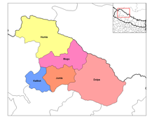
Distrikte der Zone Dhaulagiri:
Entwicklungsregion Mittelwest
Die Entwicklungsregion Mittelwest (Nepali: मध्य पश्चिमाञ्चल विकास क्षेत्र Madhya Pashchimānchal Bikās Kshetra / Entwicklungsregion der mittelwestlichen Zonen) (Englisch: Mid-Western Development Zone) bestand aus den Zonen Karnali, Rapti und Bheri.
Distrikte der Zone Karnali:
Distrikte der Zone Rapti:
- Dang Deukhuri (15)
- Pyuthan (54)
- Rolpa (58)
- Rukum (59)
- Salyan (61)
Distrikte der Zone Bheri:
Entwicklungsregion Fernwest
Die Entwicklungsregion Fernwest (Nepali: सुदुर पश्चिमाञ्चल विकास क्षेत्र Sudur Pashchimānchal Bikās Kshetra / Entwicklungsregion der fernwestlichen Zonen) (Englisch: Far-Western Development Zone) bestand aus den Zonen Seti und Mahakali.
Distrikte der Zone Seti:
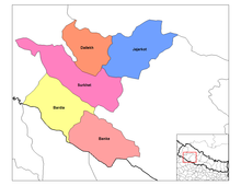
Distrikte der Zone Mahakali:
- Baitadi (4)
- Dadeldhura (13)
- Darchula (16)
- Kanchanpur (32)
Weblinks
- Distrikte, Village Development Committees und deren Daten der Volkszählung 2001 bei Digital Nepal der University of Cambridge
Einzelnachweise
- ↑ Central Bureau of Statistics, Census 2011, Final Results (Endgültige Ergebnisse) (S. 6 + 7). (Memento vom 31. Juli 2013 im Internet Archive) (PDF; 2,1 MB)
- ↑ Central Bureau of Statistics, Census 2011, Final Results (Endgültige Ergebnisse) (ab S. 8). (Memento vom 31. Juli 2013 im Internet Archive) (PDF; 2,1 MB)
- ↑ http://www.citypopulation.de/php/nepal-admin.php
- ↑ http://www.myrepublica.com/portal/index.php?action=news_details&news_id=74336
Auf dieser Seite verwendete Medien
Map of the districts of Koshi Zone (wp-EN) in Nepal. Created by Rarelibra 19:00, 18 September 2006 (UTC) for public domain use, using MapInfo Professional v8.5 and various mapping resources.
Map of the districts of Mechi Zone (wp-EN) in Nepal. Created by Rarelibra 19:32, 18 September 2006 (UTC) for public domain use, using MapInfo Professional v8.5 and various mapping resources.
Map of the districts of Bagmati Zone (wp-EN) in en:Nepal. Created by Rarelibra 18:07, 18 September 2006 (UTC) for public domain use, using MapInfo Professional v8.5 and various mapping resources.
Map of the districts of Mahakali Zone (wp-EN) in Nepal. Created by Rarelibra 19:32, 18 September 2006 (UTC) for public domain use, using MapInfo Professional v8.5 and various mapping resources.
Autor/Urheber: Hégésippe Cormier aka Hégésippe, for this new version., Lizenz: CC BY 2.5
| Französisch | Carte des subdivisions du Népal (wp-FR) : 5 régions de développement, 14 zones et 75 districts. Noms des régions en allemand. |
| Englisch | Map of subdivisions of Nepal: 5 development regions, 14 zones and 75 districts. Regions names in German. |
| Deutsch | Karte der Verwaltungsregionen Nepals (wp-DE): 5 Entwicklungsregionen, 14 Zonen und 75 Distrikte. Regionen Namen auf Deutsch. |
Map of the districts of Lumbini Zone (wp-EN) in Nepal. Created by Rarelibra 19:31, 18 September 2006 (UTC) for public domain use, using MapInfo Professional v8.5 and various mapping resources.
Map of the districts of Dhawalagiri Zone (wp-EN) in Nepal. Created by Rarelibra 18:15, 18 September 2006 (UTC) for public domain use, using MapInfo Professional v8.5 and various mapping resources.
Map of the districts of Sagarmatha Zone (wp-EN) in Nepal. Created by Rarelibra 19:35, 18 September 2006 (UTC) for public domain use, using MapInfo Professional v8.5 and various mapping resources.
Map of the districts of Rapti Zone (wp-EN) in Nepal. Created by Rarelibra 19:33, 18 September 2006 (UTC) for public domain use, using MapInfo Professional v8.5 and various mapping resources.
Map of the districts of Karnali Zone in Nepal. Created by Rarelibra 18:59, 18 September 2006 (UTC) for public domain use, using MapInfo Professional v8.5 and various mapping resources.
Map of the districts of Seti Zone (wp-EN) in Nepal. Created by Rarelibra 19:59, 18 September 2006 (UTC) for public domain use, using MapInfo Professional v8.5 and various mapping resources.
Map of the districts of Janakpur Zone (wp-EN) in Nepal. Created by Rarelibra 18:58, 18 September 2006 (UTC) for public domain use, using MapInfo Professional v8.5 and various mapping resources.
Map of the districts of Gandaki Zone (wp-EN) in Nepal. Created by Rarelibra 18:57, 18 September 2006 (UTC) for public domain use, using MapInfo Professional v8.5 and various mapping resources.
Map of the districts of Bheri Zone (wp-EN) in Nepal. Created by Rarelibra 18:12, 18 September 2006 (UTC) for public domain use, using MapInfo Professional v8.5 and various mapping resources.
Map of the districts of Narayani Zone (wp-EN) in Nepal. Created by Rarelibra 19:33, 18 September 2006 (UTC) for public domain use, using MapInfo Professional v8.5 and various mapping resources.


