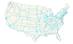
U.S. Highway 97
| Karte | |
|---|---|
 | |
| Basisdaten | |
| Gesamtlänge: | 663 mi/ 1067 km |
| Eröffnung: | 1927 |
| Bundesstaaten: | Kalifornien Oregon Washington |
| Anfangspunkt: | |
| Endpunkt: | BC 97 an der kanadischen Grenze |
Der U.S. Highway 97 ist eine Nord-Süd-Verbindung im Westen der Vereinigten Staaten. Sie beginnt an der Interstate 5 in Weed im Bundesstaat Kalifornien, führt durch Oregon und endet schließlich am British Columbia Highway 97 an der kanadischen Grenze im Bundesstaat Washington. Ein Teil der Strecke in Kalifornien und Oregon gehört zum Volcanic Legacy Scenic Byway. Seine Gesamtlänge beträgt 1067 Kilometer.
In die Straße mündet der U.S. Highway 197 zwischen Shaniko und Dallesport.
Highway 97 an der Küste des Upper Klamath Lake
Winterdienst auf dem Highway 97, südlich von Bend
Crooked River High Bridge und Rex T. Barber Bridge im Jefferson County
Beebe Bridge über den Columbia River in Washington
Weblinks
- End of US Highway 97 (englisch)
Auf dieser Seite verwendete Medien
Autor/Urheber: PGHolbrook, Lizenz: CC BY-SA 3.0
Hwy 97 runs along the eastern shore of Klamath Lake
Autor/Urheber: Oregon Department of Transportation, Lizenz: CC BY 2.0
Oregon DOT crews apply de-icer to U.S. 97 south of Bend.
Autor/Urheber: Cacophony, Lizenz: CC BY-SA 3.0
Crooked River High Bridge in Jefferson County, Oregon. Taken from the Peter Skene Ogden State Park.
600 mm × 600 mm (24 in × 24 in) U.S. Highway shield, made to the specifications of the 2004 edition of Standard Highway Signs. (Note that there is a missing "J" label on the left side of the diagram.) Uses the Roadgeek 2005 fonts. (United States law does not permit the copyrighting of typeface designs, and the fonts are meant to be copies of a U.S. Government-produced work anyway.)
600 mm × 600 mm (24 in × 24 in) U.S. Highway shield, made to the specifications of the 2004 edition of Standard Highway Signs. (Note that there is a missing "J" label on the left side of the diagram.) Uses the Roadgeek 2005 fonts. (United States law does not permit the copyrighting of typeface designs, and the fonts are meant to be copies of a U.S. Government-produced work anyway.)
Autor/Urheber: ©Mikel M. Louder Photography, Lizenz: GFDL
A photo of Beebe Bridge by Mikel Louder


