U.S. Highway 93
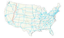
| Karte | |
|---|---|
 | |
| Basisdaten | |
| Gesamtlänge: | 1457 mi/ 2345 km |
| Eröffnung: | 1926 |
| Bundesstaaten: | Montana Idaho Nevada Arizona |
| Anfangspunkt: | |
| Endpunkt: | BC 93 an der kanadischen Grenze |
Der U.S. Highway 93 ist eine wichtige Nord-Süd-Verbindung im Westen der Vereinigten Staaten. Er beginnt am U.S. Highway 60 in Wickenburg, einer kleinen Stadt, ungefähr 90 km von Phoenix entfernt, und endet am British Columbia Highway 93 an der kanadischen Grenze.
Zwischen West Wendover und Ely gehört der Highway zum Lincoln Highway, dem ersten Highway, der Amerika durchquerte.
Beim Hoover Dam in der Nähe von Las Vegas überquert die Straße seit 2010 auf dem Hoover Dam Bypass den Colorado River.
US 93 bei Alamo
Zwischen Boulder City und dem Hoover Dam
- (c) Foto: Martina Nolte, Lizenz: Creative Commons by-sa-3.0 de
US 93 in Lakeside (Montana)
Weblinks
- End of US Highways (englisch)
Auf dieser Seite verwendete Medien
600 mm × 600 mm (24 in × 24 in) U.S. Highway shield, made to the specifications of the 2004 edition of Standard Highway Signs. (Note that there is a missing "J" label on the left side of the diagram.) Uses the Roadgeek 2005 fonts. (United States law does not permit the copyrighting of typeface designs, and the fonts are meant to be copies of a U.S. Government-produced work anyway.)
Autor/Urheber: Fietsbel, Lizenz: CC BY-SA 3.0
U.S. route 93 (southbound) between Boulder City, NV and the Hoover Dam.
600 mm × 600 mm (24 in × 24 in) U.S. Highway shield, made to the specifications of the 2004 edition of Standard Highway Signs. (Note that there is a missing "J" label on the left side of the diagram.) Uses the Roadgeek 2005 fonts. (United States law does not permit the copyrighting of typeface designs, and the fonts are meant to be copies of a U.S. Government-produced work anyway.)
(c) Foto: Martina Nolte, Lizenz: Creative Commons by-sa-3.0 de
Highway US 93 durch Lakeside (Montana)
600 mm × 600 mm (24 in × 24 in) U.S. Highway shield, made to the specifications of the 2004 edition of Standard Highway Signs. (Note that there is a missing "J" label on the left side of the diagram.) Uses the Roadgeek 2005 fonts. (United States law does not permit the copyrighting of typeface designs, and the fonts are meant to be copies of a U.S. Government-produced work anyway.)
Autor/Urheber: Cooper, in Wiki Commons known as Cooper.ch, Lizenz: CC BY-SA 2.5
northbound on US-93, Arrow Canyon Range on the far right, in the southern Nevada desert


