U.S. Highway 73
| Karte | |
|---|---|
 | |
| Basisdaten | |
| Gesamtlänge: | 112 mi/180 km |
| Eröffnung: | 1926 |
| Bundesstaaten: | Kansas Nebraska |
| Anfangspunkt: | |
| Endpunkt: | |
| Wichtige Städte: | Kansas City Leavenworth Atchison Falls City |
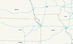
Der U.S. Highway 73 (kurz US 73) ist ein United States Highway in den Vereinigten Staaten. Er beginnt im Bundesstaat Kansas an der Interstate 70 bei Bonner Springs und endet nach 180 Kilometern am U.S. Highway 75 bei Dawson im Bundesstaat Nebraska.
Verlauf
Kansas
Ab der Interstate 70 bei Bonner Springs westlich von Kansas City verläuft der U.S. Highway 73 in nördlicher Richtung und trifft nach etwa zwei Kilometern auf die U.S. Highways 24 und 40. Ab der Stadt Leavenworth führt die Straße in nordwestlicher Richtung parallel zum Missouri River. Im Zentrum von Atchison nutzt der US 73 für etwa zwei Kilometer die Trasse des U.S. Highways 59 und verlässt die Stadt in westlicher Richtung. Ab Horton verläuft er gemeinsam mit dem U.S. Highway 159 in Richtung Norden. Die Trasse trifft südlich von Hiawatha auf den U.S. Highway 36 und erreicht nördlich von Reserve die Grenze zu Nebraska.
Nebraska
Bereits in Falls City, der ersten Stadt durch die der U.S. Highway 73 in Nebraska verläuft, trennt er sich vom U.S. Highway 159. Der US 73 verlässt Falls City in nördlicher Richtung und passiert dabei den Brenner Field Airport. Ab der Abzweigung des Dustless Highways führt der Highway in westliche Richtung und durchquert danach die Ortschaft Verdon, bevor er nach 180 Kilometern am U.S. Highway 75 nördlich von Dawson endet.
Weblinks
- US Highway Ends (englisch)
- Nebraska Highways (englisch)
Auf dieser Seite verwendete Medien
600 mm × 600 mm (24 in × 24 in) U.S. Highway shield, made to the specifications of the 2004 edition of Standard Highway Signs. (Note that there is a missing "J" label on the left side of the diagram.) Uses the Roadgeek 2005 fonts. (United States law does not permit the copyrighting of typeface designs, and the fonts are meant to be copies of a U.S. Government-produced work anyway.)
600 mm × 600 mm (24 in × 24 in) U.S. Highway shield, made to the specifications of the 2004 edition of Standard Highway Signs. (Note that there is a missing "J" label on the left side of the diagram.) Uses the Roadgeek 2005 fonts. (United States law does not permit the copyrighting of typeface designs, and the fonts are meant to be copies of a U.S. Government-produced work anyway.)
Uses the Roadgeek 2005 fonts. (United States law does not permit the copyrighting of typeface designs, and the fonts are meant to be copies of a U.S. Government-produced work anyway.) Colors are from [1] (Pantone Red 187 and Blue 294), converted to RGB by [2]. The outside border has a width of 1 (1 mm) and a color of black so it shows up; in reality, signs have no outside border.
600 mm × 600 mm (24 in × 24 in) U.S. Highway shield, made to the specifications of the 2004 edition of Standard Highway Signs. (Note that there is a missing "J" label on the left side of the diagram.) Uses the Roadgeek 2005 fonts. (United States law does not permit the copyrighting of typeface designs, and the fonts are meant to be copies of a U.S. Government-produced work anyway.)


