U.S. Highway 7
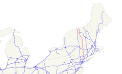
| Karte | |
|---|---|
 | |
| Basisdaten | |
| Gesamtlänge: | 308 mi/496 km |
| Eröffnung: | 1926 |
| Bundesstaaten: | Connecticut Massachusetts Vermont |
| Anfangspunkt: | |
| Endpunkt: | |
Der U.S. Highway 7 (kurz US 7) ist ein 496 km langer Nord-Süd United States Highway in den Vereinigten Staaten. Er beginnt an der Interstate 95 in Norwalk im Bundesstaat Connecticut und endet in der kanadischen Grenze bei Highgate Springs an der Interstate 89.
Geschichte
Vor dem U.S. Highway System gehörte der Abschnitt von Great Barrington bis zur kanadischen Grenze zur New England Interstate Route 4 (NE-4). Seit 1927 verläuft sie entlang der NE-4 und der Massachusetts State Route 41. Die Connecticut State Route 41 führt dann weiter bis zu der Stadt Sharon. Die NE-4 führte dann weiter über die Connecticut State Route 343 bis zur Grenze zu dem Bundesstaat New York entlang der New York State Route 343 nach Amenia. Die US 7 verlief dann ursprünglich über New York State Route 22 nach New York City. 1929 wurde das südliche Ende nach Norwalk verschoben. Die ehemalige Bezeichnungen dieser Strecke waren bis nach North Canaan New England Route 17, bis nach New Milford State Route 134, bis nach Danbury State Route 128, New England Route 3 bis Ridgefield und State Route 126 bis Norwalk.
Weblinks
- US Highway Ends (englisch)
Auf dieser Seite verwendete Medien
Autor/Urheber: John Phelan, Lizenz: CC BY 3.0
US Route 7 southbound entering New Ashford Massachusetts
600 mm × 600 mm (24 in × 24 in) U.S. Highway shield, made to the specifications of the 2004 edition of Standard Highway Signs. (Note that there is a missing "J" label on the left side of the diagram.) Uses the Roadgeek 2005 fonts. (United States law does not permit the copyrighting of typeface designs, and the fonts are meant to be copies of a U.S. Government-produced work anyway.)
600 mm × 600 mm (24 in × 24 in) U.S. Highway shield, made to the specifications of the 2004 edition of Standard Highway Signs. (Note that there is a missing "J" label on the left side of the diagram.) Uses the Roadgeek 2005 fonts. (United States law does not permit the copyrighting of typeface designs, and the fonts are meant to be copies of a U.S. Government-produced work anyway.)


