U.S. Highway 34
| Karte | |
|---|---|
 | |
| Basisdaten | |
| Gesamtlänge: | 1122 mi / 1806 km[1] |
| Eröffnung: | 1926 |
| Bundesstaaten: | Colorado Nebraska Iowa Illinois |
| Anfangspunkt: | |
| Endpunkt: | |
| Wichtige Städte: | Loveland, CO Greeley, CO Grand Island, NE Lincoln, NE Ottumwa, IA Burlington, IA Naperville, IL |
Der U.S. Highway 34 ist ein 1806 km langer in West-Ost-Richtung verlaufender Highway durch die Mitte und den Norden der USA.[2]
Seinen westlichen Endpunkt bildet die Einmündung in den U.S. Highway 40 bei Granby inmitten der Rocky Mountains in Colorado. Das östliche Ende befindet sich an der Einmündung in die Illinois State Route 43 in Berwyn (Illinois) im westlichen Vorortbereich von Chicago.
Verlauf
Die wichtigsten Kreuzungen und Einmündungen
 U.S. Highway 40 bei Granby, Colorado
 U.S. Highway 36 bei Estes Park, Colorado
 U.S. Highway 287 in Loveland, Colorado
 Interstate 25 /
  U.S. Highway 87 bei Loveland
 U.S. Highway 85 bei Greeley, Colorado
 Interstate 76 /
  U.S. Highway 6 von Wiggins, Colorado bis westlich von Fort Morgan, Colorado – 15 km gemeinsamer Verlauf
 U.S. Highway 385 in Wray, Colorado
 U.S. Highway 6 von Culbertson, Nebraska bis Hastings, Nebraska – 226 km gemeinsamer Verlauf
 U.S. Highway 83 in McCook, Nebraska
 U.S. Highway 283 in Arapahoe, Nebraska
 U.S. Highway 136 nördlich von Edison, Nebraska
 U.S. Highway 183 in Holdrege, Nebraska
 U.S. Highway 281 von Hastings bis Grand Island, Nebraska – 34 km gemeinsamer Verlauf
 U.S. Highway 81 bei York, Nebraska
 Interstate 80 /
  U.S. Highway 77 bei Lincoln, Nebraska
 U.S. Highway 6 in Lincoln
 U.S. Highway 75 von Union, Nebraska bis Plattsmouth, Nebraska – 21 km gemeinsamer Verlauf
 Interstate 29 bei Pacific Junction, Iowa
 U.S. Highway 275 südlich von Glenwood, Iowa – sieben Kilometer gemeinsamer Verlauf
 U.S. Highway 59 nördlich von Emerson, Iowa
 U.S. Highway 71 nördlich von Villisca, Iowa
 U.S. Highway 169 bei Afton, Iowa
 Interstate 35 bei Osceola, Iowa
 U.S. Highway 69 in Osceola
 U.S. Highway 65 westlich von Canton, Iowa
 U.S. Highway 63 in Ottumwa, Iowa
 U.S. Highway 218 bei Mount Pleasant, Iowa
 U.S. Highway 61 bei Burlington, Iowa
 U.S. Highway 67 bei Monmouth, Illinois
 Interstate 74 bei Galesburg, Illinois
 U.S. Highway 6 westlich von Princeton, Illinois – 25 km gemeinsamer Verlauf
 Interstate 80 nordöstlich von Princeton
 U.S. Highway 52 in Mendota, Illinois
 Interstate 39 /
  U.S. Highway 52 östlich von Mendota
 U.S. Highway 30 westlich von Oswego, Illinois
 Interstate 355 am Westrand von Downers Grove, Illinois
 Interstate 294 am Westrand von Western Springs, Illinois
 U.S. Highway 12 /
  U.S. Highway 20 westlich von Brookfield, Illinois
 Illinois State Route 43 in Berwyn, Illinois
| Bundesstaat | Meilen[3] | Kilometer |
|---|---|---|
| Colorado | 258 | 415 |
| Nebraska | 382 | 614 |
| Iowa | 272 | 438 |
| Illinois | 211 | 339 |
| Gesamt | 1.222 | 1.806 |
Colorado
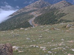
Die Strecke durch den Rocky-Mountain-Nationalpark ist auch als Trail Ridge Road, die mit 3713 m höchstgelegene Asphaltstraße der USA, bekannt.
Der Highway 34 führt zunächst nach Norden, wo er mit dem Milner Pass und dem Front River Pass die Front Range und damit den höchstgelegenen Abschnitt überwindet.
Bei Estes Park mündet der U.S. Highway 36 ein, der hier seinen westlichen Endpunkt erreicht hat. Die Straße führt nun geradewegs nach Osten, parallel zum Big Thompson River und kreuzt in Loveland den U.S. Highway 287 sowie östlich der Stadt die Interstate 25. In der östlichen Nachbarstadt Greeley trifft der Highway 34 auf den U.S. Highway 85. Auf seiner Strecke durch Greeley teilt sich der Highway 34 in eine nördliche und eine südliche Route, die sich östlich der Stadt wieder vereinigen.
Die Straße führt nun weiter in ostsüdöstlicher Richtung und vereinigt sich bei Wiggins mit dem gemeinsam mit der Interstate 76 verlaufenden U.S. Highway 6. Westlich von Fort Morgan verlässt der Highway 34 die gemeinsame Strecke wieder nach Südosten, um im weiter östlich gelegenen Wray den U.S. Highway 385 zu kreuzen und nach wenigen Kilometern in Richtung Osten die Grenze zwischen den Bundesstaaten Colorado und Nebraska zu erreichen.
Nebraska
Der Highway 34 bildet die wichtigste West-Ost-Achse im südlichen Nebraska.
Bei der kleinen Ortschaft Haigler gelangt der Highway 34 nach Nebraska und führt durch eine Reihe weiterer kleiner Ortschaften nach Osten. Westlich von Culbertson beginnt eine weitere gemeinsame Strecke mit dem Highway 6 mit 226 km Länge. Wenige Kilometer östlich kreuzt in McCook der U.S. Highway 83, kurz danach mündet der U.S. Highway 136 ein und die gemeinsame Strecke der Highways 6 und 34 führt nun weiter nach Osten. Wenig später biegt die Straße nach Nordosten ab und erreicht in Holdrege die Kreuzung mit dem U.S. Highway 183. In Hastings endet der gemeinsame Verlauf mit dem Highway 6. Der Highway 34 biegt hier gemeinsam mit dem U.S. Highway 281 nach Norden ab. Danach überquert die Straße den Platte River.
Nach der Kreuzung mit der Interstate 80 biegt der Highway 34 südlich von Grand Island nach Osten ab und überquert erneut den Platte River. Nördlich von York kreuzt der U.S. Highway 81. Weiter östlich erreicht der Highway 34 mit dem Flughafen Lincoln das Stadtgebiet der Hauptstadt von Nebraska. Die Straße führt nun mitten durch die Stadt und trifft dabei erneut auf den Highway 6 sowie die Interstate 80 und den mit ihr gemeinsam verlaufenden U.S. Highway 77.
Nach dem Verlassen der Stadt Lincoln führt der Highway 34 schnurgerade nach Osten, bis er bei Union auf den U.S. Highway 75 trifft und mit diesem gemeinsam in gerader Linie nach Norden führt. Im nur wenige Kilometer südlich von Omaha liegenden Plattsmouth, das seinen Namen von der nahen Mündung des Platte River in den Missouri River hat, biegt der Highway 34 wieder nach Osten ab und erreicht den Missouri River, der die Grenze zwischen den Bundesstaaten Nebraska und Iowa bildet.
Iowa

In Iowa ist der Highway 34 die wichtigste West-Ost-Verbindung im Süden des Staates unweit der Grenze nach Kansas.
Nach Iowa gelangt die Straße über die den Missouri überquerende Plattsmouth Bridge zwischen Plattsmouth und Pacific Junction, wo die Interstate 29 versetzt gekreuzt wird, ebenso wie bei Glenwood der U.S. Highway 275. Nördlich von Emerson kreuzt der U.S. Highway 59. Der Highway führt auf seinem Weg nach Osten am Viking Lake State Park vorbei und kreuzt wenige Kilometer westlich davon den U.S. Highway 71. Bei Afton mündet von Süden kommend der U.S. Highway 169 ein und verlässt nach sieben Kilometern gemeinsamer Strecke diese wieder in nördlicher Richtung. Am Westrand von Osceola kreuzt die Interstate 35, in der Stadt besteht eine Kreuzung mit dem U.S. Highway 69. In der weiter östlich gelegenen Stadt Ottumwa kreuzt der U.S. Highway 63.
In Mount Pleasant teilt sich der Highway 34 in eine nördliche und eine südliche Route und trifft an der östlichen Umgehungsstraße auf den U.S. Highway 218. Die Straße biegt nun nach Südosten ab und führt wenig später am nördlichen Rand des Geländes der Iowa Army Ammunition Plant (Armee-Munitionsfabrik von Iowa) entlang. Nach West Burlington kreuzt der U.S. Highway 61 und die Stadt führt nun nördlich der Innenstadt durch Burlington am Mississippi River. Dieser bildet die Grenze zu Illinois, das über die Great River Bridge erreicht wird.
Der größte Teil der Strecke durch Iowa wird auch Bluegrass Highway genannt. Parallel zum Highway 34 verläuft die Strecke der BNSF Railway, über die auch der Personenschnellzug California Zephyr von Amtrak verläuft.
Offiziell gibt es für den Highway 34 in Iowa auch die Bezeichnung Red Bull Highway, benannt nach der 34. US-Infanteriedivision (Red Bull).
Illinois

Nachdem der Highway von Iowa kommend den Staat Illinois erreicht hat, trifft er in seinem ostnordöstlichen Verlauf bei der Umfahrung von Monmouth auf den U.S. Highway 67. Auf der nordwestlichen Umgehungsstraße von Galesburg kreuzt der U.S. Highway 150, nördlich der Stadt die Interstate 74.
Weiter verläuft die Straße nach Nordosten. Westlich von Princeton trifft der Highway 6 erneut auf den Highway 34 und verläuft mit diesem auf einer 25 km langen gemeinsamen Strecke. Im Zentrum der Stadt Princeton verlässt der Highway 34 die gemeinsame Strecke wieder in nordöstlicher Richtung und kreuzt am nordöstlichen Rand der Stadt erneut die Interstate 80. Kurz vor der Stadt Mendota ändert der Highway 34 seine Richtung wieder nach Osten, in der Innenstadt kreuzt der U.S. Highway 52. Östlich der Stadt überquert der Highway 34 die Interstate 39 und den mit ihr gemeinsam verlaufenden U.S. Highway 51.
Die Straße verläuft nun weiter in ostnordöstlicher Richtung und tritt in Oswego in den Großraum Chicago ein. Hinter Oswego kreuzt der U.S. Highway 30. Von nun an trägt der Highway 34 bis zu seinem Ende den Namen Ogden Avenue, benannt nach William Butler Ogden, dem ersten Bürgermeister von Chicago. Der Highway 34 führt nun durch Naperville und kreuzt vor Downers Grove die Interstate 355. Am westlichen Rand von Western Springs kreuzt die Interstate 294. Weiter östlich kreuzt der Highway 34 die gemeinsam verlaufenden U.S. Highways 20 und 45, bevor in Berwyn mit der Einmündung in die Illinois State Route 43 das östliche Ende des Highway 34 erreicht wird.[4]
Bevor die Interstate 55 fertiggestellt wurde, verliefen die Route 66 und der Highway 34 gemeinsam durch den Großraum Chicago. Mit der gänzlichen Auflösung der Route 66 wurde auch der Endpunkt des Highway 34 aus dem Zentrum von Chicago weiter südwestlich an seine heutige Stelle verlegt.
Zukunft
Es ist geplant, eine neue Brücke von Nebraska nach Iowa über den Missouri River zu bauen. Diese soll weiter nördlich südlich von Bellevue (Nebraska) am Flughafen Omaha stehen.[5]
Siehe auch
Weblinks
Einzelnachweise
- ↑ US-Highways ( des vom 13. Mai 2007 im Internet Archive) Info: Der Archivlink wurde automatisch eingesetzt und noch nicht geprüft. Bitte prüfe Original- und Archivlink gemäß Anleitung und entferne dann diesen Hinweis.
- ↑ End of US highway 34. US Ends.com, 24. August 2017, abgerufen am 27. Dezember 2017.
- ↑ Google Maps
- ↑ Illinois Highway Ends: US 34 ( des vom 10. Oktober 2012 im Internet Archive) Info: Der Archivlink wurde automatisch eingesetzt und noch nicht geprüft. Bitte prüfe Original- und Archivlink gemäß Anleitung und entferne dann diesen Hinweis.
- ↑ US 34 Bellevue (PDF; 107 kB)
Auf dieser Seite verwendete Medien
600 mm × 600 mm (24 in × 24 in) U.S. Highway shield, made to the specifications of the 2004 edition of Standard Highway Signs. (Note that there is a missing "J" label on the left side of the diagram.) Uses the Roadgeek 2005 fonts. (United States law does not permit the copyrighting of typeface designs, and the fonts are meant to be copies of a U.S. Government-produced work anyway.)
600 mm × 600 mm (24 in × 24 in) U.S. Highway shield, made to the specifications of the 2004 edition of Standard Highway Signs. (Note that there is a missing "J" label on the left side of the diagram.) Uses the Roadgeek 2005 fonts. (United States law does not permit the copyrighting of typeface designs, and the fonts are meant to be copies of a U.S. Government-produced work anyway.)
600 mm × 600 mm (24 in × 24 in) U.S. Highway shield, made to the specifications of the 2004 edition of Standard Highway Signs. (Note that there is a missing "J" label on the left side of the diagram.) Uses the Roadgeek 2005 fonts. (United States law does not permit the copyrighting of typeface designs, and the fonts are meant to be copies of a U.S. Government-produced work anyway.)
600 mm × 600 mm (24 in × 24 in) U.S. Highway shield, made to the specifications of the 2004 edition of Standard Highway Signs. (Note that there is a missing "J" label on the left side of the diagram.) Uses the Roadgeek 2005 fonts. (United States law does not permit the copyrighting of typeface designs, and the fonts are meant to be copies of a U.S. Government-produced work anyway.)
600 mm × 600 mm (24 in × 24 in) U.S. Highway shield, made to the specifications of the 2004 edition of Standard Highway Signs. (Note that there is a missing "J" label on the left side of the diagram.) Uses the Roadgeek 2005 fonts. (United States law does not permit the copyrighting of typeface designs, and the fonts are meant to be copies of a U.S. Government-produced work anyway.)
600 mm × 600 mm (24 in × 24 in) U.S. Highway shield, made to the specifications of the 2004 edition of Standard Highway Signs. (Note that there is a missing "J" label on the left side of the diagram.) Uses the Roadgeek 2005 fonts. (United States law does not permit the copyrighting of typeface designs, and the fonts are meant to be copies of a U.S. Government-produced work anyway.)
750 mm × 600 mm (30 in × 24 in) U.S. Highway shield, made to the specifications of the 2004 edition of Standard Highway Signs. (Note that there is a missing "J" label on the left side of the diagram.) Uses the Roadgeek 2005 fonts. (United States law does not permit the copyrighting of typeface designs, and the fonts are meant to be copies of a U.S. Government-produced work anyway.)
750 mm × 600 mm (30 in × 24 in) U.S. Highway shield, made to the specifications of the 2004 edition of Standard Highway Signs. (Note that there is a missing "J" label on the left side of the diagram.) Uses the Roadgeek 2005 fonts. (United States law does not permit the copyrighting of typeface designs, and the fonts are meant to be copies of a U.S. Government-produced work anyway.)
750 mm × 600 mm (30 in × 24 in) U.S. Highway shield, made to the specifications of the 2004 edition of Standard Highway Signs. (Note that there is a missing "J" label on the left side of the diagram.) Uses the Roadgeek 2005 fonts. (United States law does not permit the copyrighting of typeface designs, and the fonts are meant to be copies of a U.S. Government-produced work anyway.)
750 mm × 600 mm (30 in × 24 in) U.S. Highway shield, made to the specifications of the 2004 edition of Standard Highway Signs. (Note that there is a missing "J" label on the left side of the diagram.) Uses the Roadgeek 2005 fonts. (United States law does not permit the copyrighting of typeface designs, and the fonts are meant to be copies of a U.S. Government-produced work anyway.)
600 mm × 600 mm (24 in × 24 in) U.S. Highway shield, made to the specifications of the 2004 edition of Standard Highway Signs. (Note that there is a missing "J" label on the left side of the diagram.) Uses the Roadgeek 2005 fonts. (United States law does not permit the copyrighting of typeface designs, and the fonts are meant to be copies of a U.S. Government-produced work anyway.)
600 mm × 600 mm (24 in × 24 in) U.S. Highway shield, made to the specifications of the 2004 edition of Standard Highway Signs. (Note that there is a missing "J" label on the left side of the diagram.) Uses the Roadgeek 2005 fonts. (United States law does not permit the copyrighting of typeface designs, and the fonts are meant to be copies of a U.S. Government-produced work anyway.)
600 mm × 600 mm (24 in × 24 in) U.S. Highway shield, made to the specifications of the 2004 edition of Standard Highway Signs. (Note that there is a missing "J" label on the left side of the diagram.) Uses the Roadgeek 2005 fonts. (United States law does not permit the copyrighting of typeface designs, and the fonts are meant to be copies of a U.S. Government-produced work anyway.)
750 mm × 600 mm (30 in × 24 in) U.S. Highway shield, made to the specifications of the 2004 edition of Standard Highway Signs. (Note that there is a missing "J" label on the left side of the diagram.) Uses the Roadgeek 2005 fonts. (United States law does not permit the copyrighting of typeface designs, and the fonts are meant to be copies of a U.S. Government-produced work anyway.)
600 mm × 600 mm (24 in × 24 in) U.S. Highway shield, made to the specifications of the 2004 edition of Standard Highway Signs. (Note that there is a missing "J" label on the left side of the diagram.) Uses the Roadgeek 2005 fonts. (United States law does not permit the copyrighting of typeface designs, and the fonts are meant to be copies of a U.S. Government-produced work anyway.)
750 mm × 600 mm (30 in × 24 in) U.S. Highway shield, made to the specifications of the 2004 edition of Standard Highway Signs. (Note that there is a missing "J" label on the left side of the diagram.) Uses the Roadgeek 2005 fonts. (United States law does not permit the copyrighting of typeface designs, and the fonts are meant to be copies of a U.S. Government-produced work anyway.)
750 mm × 600 mm (30 in × 24 in) U.S. Highway shield, made to the specifications of the 2004 edition of Standard Highway Signs. (Note that there is a missing "J" label on the left side of the diagram.) Uses the Roadgeek 2005 fonts. (United States law does not permit the copyrighting of typeface designs, and the fonts are meant to be copies of a U.S. Government-produced work anyway.)
600 mm × 600 mm (24 in × 24 in) U.S. Highway shield, made to the specifications of the 2004 edition of Standard Highway Signs. (Note that there is a missing "J" label on the left side of the diagram.) Uses the Roadgeek 2005 fonts. (United States law does not permit the copyrighting of typeface designs, and the fonts are meant to be copies of a U.S. Government-produced work anyway.)
600 mm × 600 mm (24 in × 24 in) U.S. Highway shield, made to the specifications of the 2004 edition of Standard Highway Signs. (Note that there is a missing "J" label on the left side of the diagram.) Uses the Roadgeek 2005 fonts. (United States law does not permit the copyrighting of typeface designs, and the fonts are meant to be copies of a U.S. Government-produced work anyway.)
600 mm × 600 mm (24 in × 24 in) U.S. Highway shield, made to the specifications of the 2004 edition of Standard Highway Signs. (Note that there is a missing "J" label on the left side of the diagram.) Uses the Roadgeek 2005 fonts. (United States law does not permit the copyrighting of typeface designs, and the fonts are meant to be copies of a U.S. Government-produced work anyway.)
600 mm × 600 mm (24 in × 24 in) U.S. Highway shield, made to the specifications of the 2004 edition of Standard Highway Signs. (Note that there is a missing "J" label on the left side of the diagram.) Uses the Roadgeek 2005 fonts. (United States law does not permit the copyrighting of typeface designs, and the fonts are meant to be copies of a U.S. Government-produced work anyway.)
600 mm × 600 mm (24 in × 24 in) U.S. Highway shield, made to the specifications of the 2004 edition of Standard Highway Signs. (Note that there is a missing "J" label on the left side of the diagram.) Uses the Roadgeek 2005 fonts. (United States law does not permit the copyrighting of typeface designs, and the fonts are meant to be copies of a U.S. Government-produced work anyway.)
24 in by 24 in (600 mm by 600 mm) Illinois Route shield, made to the specifications of the sign detail (sign M-I100). Uses the Roadgeek 2005 fonts. (United States law does not permit the copyrighting of typeface designs, and the fonts are meant to be copies of a U.S. Government-produced work anyway.) The outside border has a width of 1 (1/16 in) and a color of black so it shows up; in reality, signs have no outside border.
Great River Bridge over the Mississippi River at Burlington, Iowa.
600 mm × 600 mm (24 in × 24 in) U.S. Highway shield, made to the specifications of the 2004 edition of Standard Highway Signs. (Note that there is a missing "J" label on the left side of the diagram.) Uses the Roadgeek 2005 fonts. (United States law does not permit the copyrighting of typeface designs, and the fonts are meant to be copies of a U.S. Government-produced work anyway.)
600 mm × 600 mm (24 in × 24 in) U.S. Highway shield, made to the specifications of the 2004 edition of Standard Highway Signs. (Note that there is a missing "J" label on the left side of the diagram.) Uses the Roadgeek 2005 fonts. (United States law does not permit the copyrighting of typeface designs, and the fonts are meant to be copies of a U.S. Government-produced work anyway.)
600 mm × 600 mm (24 in × 24 in) U.S. Highway shield, made to the specifications of the 2004 edition of Standard Highway Signs. (Note that there is a missing "J" label on the left side of the diagram.) Uses the Roadgeek 2005 fonts. (United States law does not permit the copyrighting of typeface designs, and the fonts are meant to be copies of a U.S. Government-produced work anyway.)
750 mm × 600 mm (30 in × 24 in) U.S. Highway shield, made to the specifications of the 2004 edition of Standard Highway Signs. (Note that there is a missing "J" label on the left side of the diagram.) Uses the Roadgeek 2005 fonts. (United States law does not permit the copyrighting of typeface designs, and the fonts are meant to be copies of a U.S. Government-produced work anyway.)
Autor/Urheber: Die Autorenschaft wurde nicht in einer maschinell lesbaren Form angegeben. Es wird Kelly Martin als Autor angenommen (basierend auf den Rechteinhaber-Angaben)., Lizenz: CC BY-SA 3.0
U.S. Highway 34 in west-central Illinois, west of Oneida, Illinois. Photograph taken June 4, 2006 by Kelly Martin.
750 mm × 600 mm (30 in × 24 in) U.S. Highway shield, made to the specifications of the 2004 edition of Standard Highway Signs. (Note that there is a missing "J" label on the left side of the diagram.) Uses the Roadgeek 2005 fonts. (United States law does not permit the copyrighting of typeface designs, and the fonts are meant to be copies of a U.S. Government-produced work anyway.)
600 mm × 600 mm (24 in × 24 in) U.S. Highway shield, made to the specifications of the 2004 edition of Standard Highway Signs. (Note that there is a missing "J" label on the left side of the diagram.) Uses the Roadgeek 2005 fonts. (United States law does not permit the copyrighting of typeface designs, and the fonts are meant to be copies of a U.S. Government-produced work anyway.)
View of Trail Ridge Road from a hill in Rocky Mountain National Park, at an elevation of nearly 11,700 feet.
600 mm × 600 mm (24 in × 24 in) U.S. Highway shield, made to the specifications of the 2004 edition of Standard Highway Signs. (Note that there is a missing "J" label on the left side of the diagram.) Uses the Roadgeek 2005 fonts. (United States law does not permit the copyrighting of typeface designs, and the fonts are meant to be copies of a U.S. Government-produced work anyway.)
600 mm by 600 mm (24 in by 24 in) Interstate shield, made to the specifications of the 2004 edition of Standard Highway Signs (sign M1-1). Uses the Roadgeek 2005 fonts. (United States law does not permit the copyrighting of typeface designs, and the fonts are meant to be copies of a U.S. Government-produced work anyway.) Colors are from [1] (Pantone Red 187 and Blue 294), converted to RGB by [2]. The outside border has a width of 1 (1 mm) and a color of black so it shows up; in reality, signs have no outside border.
600 mm × 600 mm (24 in × 24 in) U.S. Highway shield, made to the specifications of the 2004 edition of Standard Highway Signs. (Note that there is a missing "J" label on the left side of the diagram.) Uses the Roadgeek 2005 fonts. (United States law does not permit the copyrighting of typeface designs, and the fonts are meant to be copies of a U.S. Government-produced work anyway.)
600 mm × 600 mm (24 in × 24 in) U.S. Highway shield, made to the specifications of the 2004 edition of Standard Highway Signs. (Note that there is a missing "J" label on the left side of the diagram.) Uses the Roadgeek 2005 fonts. (United States law does not permit the copyrighting of typeface designs, and the fonts are meant to be copies of a U.S. Government-produced work anyway.)


