U.S. Highway 3
| Karte | |
|---|---|
 | |
| Basisdaten | |
| Gesamtlänge: | 277 mi/446 km |
| Eröffnung: | 1926 |
| Bundesstaaten: | Massachusetts New Hampshire |
| Anfangspunkt: | |
| Endpunkt: | |
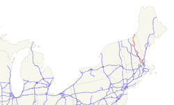
Der U.S. Highway 3 (kurz US 3) ist ein United States Highway in den Vereinigten Staaten. Er beginnt an der Massachusetts Route 2A bzw. Route 3 in Cambridge und endet nach 446 Kilometern in Pittsburg an der kanadischen Grenze, nach welcher die Straße als Quebec Route 257 weiter führt.
In New Hampshire sind Abschnitte des Highways als Daniel Webster Highway bekannt. Zwischen den Städten Burlington in Massachusetts und Nashua in New Hampshire wurde der US 3 als Freeway ausgebaut. Auf einer Länge von 10,8 Kilometern gehört er außerdem zum Everett Turnpike.
Verlauf
Massachusetts
Nach seinem Beginn in der Innenstadt von Cambridge verläuft der Highway durch Vororte bis zu einem Kreuz mit der Interstate 95 und der Massachusetts Route 128 im Südwesten von Burlington. Ab diesem Kreuz ist er bis Nashua als Freeway ausgebaut. Im Süden von Lowell kreuzt der US 3 die Interstate 495. Nördlich von Tyngsborough erreicht der Highway die Grenze zu New Hampshire.
New Hampshire
Ab der Grenze bildet er für elf Kilometer bis Nashua den ersten Abschnitt des Everett Turnpike, der nach 64 Kilometern in Concord endet. Von Nashua bis Concorde verläuft der U.S. Highway 3 parallel zum Merrimack River, zum Everett Turnpike und ab Manchester auch zur Interstate 93. Bis kurz vor der Stadt Franconia trifft der US 3 immer wieder auf die I-93, bis er von dort in nordöstlicher Richtung verläuft. Nördlich der Connecticut Lakes erreicht der U.S. Highway 3 anschließend die kanadische Grenze zwischen dem Third Lake und Chartierville.
Weblinks
- Northwest Expressway (englisch)
- US Highway Ends (englisch)
- AARoads New Hampshire (englisch)
Auf dieser Seite verwendete Medien
600 mm × 600 mm (24 in × 24 in) U.S. Highway shield, made to the specifications of the 2004 edition of Standard Highway Signs. (Note that there is a missing "J" label on the left side of the diagram.) Uses the Roadgeek 2005 fonts. (United States law does not permit the copyrighting of typeface designs, and the fonts are meant to be copies of a U.S. Government-produced work anyway.)
600 mm × 600 mm (24 in × 24 in) U.S. Highway shield, made to the specifications of the 2004 edition of Standard Highway Signs. (Note that there is a missing "J" label on the left side of the diagram.) Uses the Roadgeek 2005 fonts. (United States law does not permit the copyrighting of typeface designs, and the fonts are meant to be copies of a U.S. Government-produced work anyway.)
600 mm by 600 mm (24 in by 24 in) Massachusetts Route shield, made to the specifications of the 1996 edition of Construction and Traffic Standard Details (sign M1-5). Uses the Roadgeek 2005 fonts. (United States law does not permit the copyrighting of typeface designs, and the fonts are meant to be copies of a U.S. Government-produced work anyway.) The outside border has a width of 1 (1 mm) and a color of black so it shows up; in reality, signs have no outside border. The specs actually do not show the curve on the outside border, instead making it a perfect square, but all signs I have seen round the corners.
600 mm by 600 mm (24 in by 24 in) Massachusetts Route shield, made to the specifications of the 1996 edition of Construction and Traffic Standard Details (sign M1-5). Uses the Roadgeek 2005 fonts. (United States law does not permit the copyrighting of typeface designs, and the fonts are meant to be copies of a U.S. Government-produced work anyway.) The outside border has a width of 1 (1 mm) and a color of black so it shows up; in reality, signs have no outside border. The specs actually do not show the curve on the outside border, instead making it a perfect square, but all signs I have seen round the corners.


