U.S. Highway 218
| Karte | |
|---|---|
| Basisdaten | |
| Gesamtlänge: | 319 mi / 513 km[1] |
| Eröffnung: | 1926 |
| Bundesstaaten: | Iowa Minnesota |
| Anfangspunkt: | |
| Endpunkt: | |
| Wichtige Städte: | Keokuk, IA Iowa City, IA Cedar Rapids, IA Waterloo, IA Austin, MN Owatonna, MN |
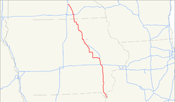
Der U.S. Highway 218 ist ein 513 km langer in Süd-Nord-Richtung verlaufender Highway durch die Mitte der USA. Der Highway 218 gehört zu den original im Jahre 1926 eingerichteten Fernstraßen.[2] Obwohl die Nummerierung 218 bedeuten würde, dass es sich um eine Entlastungsstraße für den U.S. Highway 18 handeln müsste, überlappen sich beide Highways nur 13 km bei Charles City und trennen sich danach wieder.
Der südliche Endpunkt des Highway 218 befindet sich an der Einmündung in den U.S. Highway 136 im Stadtzentrum von Keokuk im südöstlichen Zipfel von Iowa. Das nördliche Ende bildet die gemeinsame Einmündung mit dem U.S. Highway 14 in die Interstate 35 am Südrand von Owatonna im südlichen Minnesota.
Verlauf
Die wichtigsten Kreuzungen und Einmündungen
 U.S. Highway 136 in Keokuk, Iowa
 U.S. Highway 61 nördlich von Keokuk – 9 km gemeinsamer Verlauf
 U.S. Highway 34 bei Mount Pleasant, Iowa
 Interstate 80 bei Iowa City, Iowa
 U.S. Highway 6 bei Iowa City, Iowa
 Interstate 380 von Iowa City bis Cedar Rapids, Iowa – 26 km gemeinsamer Verlauf
 U.S. Highway 151 bei Cedar Rapids, Iowa
 U.S. Highway 30 westlich von Cedar Rapids – 30 km gemeinsamer Verlauf
 Interstate 380 /
  U.S. Highway 20 südwestlich von Waterloo, Iowa
 U.S. Highway 63 in Waterloo
 U.S. Highway 18 nordwestlich von Charles City, Iowa – 13 km gemeinsamer Verlauf
 Interstate 90 bei Austin, Minnesota
 I-35 /
  US 14 bei Owatonna, Minnesota
Iowa
Der Highway 218 ist auf seinem Verlauf durch Iowa zu einem großen Teil deckungsgleich mit der Avenue of the Saints, in Iowa auch als Iowa Highway 27 nummeriert.
Der südliche Endpunkt des Highway 218 befindet sich an der Einmündung in den U.S. Highway 136 im Zentrum von Keokuk an der Schnittstelle von Iowa, Illinois und Missouri. Als Main Street führt der Highway 218 durch die gesamte Stadt, bis am Nordwestrand von Keokuk ein 9 km langer gemeinsamer Verlauf mit dem U.S. Highway 61 nach Norden beginnt. Nachdem sich beide Highways wieder getrennt haben, führt der Highway 218 nun nach Nordwesten.
Südlich von Donnellson trifft der Highway 218 zum ersten Mal auf den Iowa Highway 27 (Avenue of the Saints) und verläuft nun mit diesem gemeinsam in nördlicher Richtung. Am Ostrand von Mount Pleasant kreuzt der U.S. Highway 34 und der Highway 218 führt weiter nach Norden. An Iowa City führt der Highway 218 als südwestliche Tangente vorbei und kreuzt nacheinander die Interstate 80 und den U.S. Highway 6. Nun führt der Highway 218 als Interstate 380 nach Norden, um am Südrand von Cedar Rapids die gemeinsame Strecke nach Westen zu verlassen. Gleichzeitig trifft der Highway 218 auf den U.S. Highway 151 und den U.S. Highway 30, mit dem die Straße nun die nächsten 30 km gemeinsam nach Westen führt.
Danach verlässt der Highway 218 die gemeinsame Strecke nach Norden, um bei Vinton wieder nach Westen und wenige Kilometer später erneut nach Norden abzubiegen. Am südwestlichen Stadtrand von Waterloo trifft der Highway 218 erneut auf die Interstate 380 und auf den mit dieser gemeinsam verlaufenden U.S. Highway 20. Die Straße führt nun durch das Stadtzentrum von Waterloo, wo der U.S. Highway 63 kreuzt und danach in nordwestlicher Richtung an den Nordrand von Cedar Falls. Vorn dort führt der Highway 218 wieder nach Norden.
Bei Charles City trifft der Highway 218 auf den U.S. Highway 18 und verläuft 13 km gemeinsam mit diesem. Danach verlässt der Highway 218 die gemeinsame Strecke wieder in nördlicher Richtung. Nach einigen rechtwinklige Kurven in nördlicher und westlicher Richtung erreicht der Highway 218 die Grenze zwischen den Bundesstaaten Iowa und Minnesota.
Minnesota
Von Süden kommend erreicht der Highway 218 den östlichen Stadtrand von Austin und bildet die östliche Umgehungsstraße der Stadt. Am Regionalflughafen von Austin mündet der Highway in die Interstate 90 und verläuft am nördlichen Stadtrand einige Kilometer mit dieser gemeinsam nach Westen. Wenig später endet die gemeinsame Strecke und der Highway 218 biegt nach Norden ab.
Der Highway 218 führt nun durch eine Reihe kleinerer Ortschaften in nördlicher Richtung, bevor er am südöstlichen Stadtrand von Owatonna in den U.S. Highway 14 einmündet und mit diesem gemeinsam nach Westen verläuft. Nach 5 km erreicht der Highway 218 seinen nördlichen Endpunkt mit der Einmündung in die Interstate 35.[3]
Offiziell ist der Highway 218 auf seinem Abschnitt in Minnesota gemäß Minnesota Statutes § 161.114(2) als Route 40 ausgewiesen.[4]
Geschichte
1913 wurde die Straße gebaut, die heute als Highway 218 landesweit ausgewiesen ist. Die heutige Straße wurde zuerst Red Ball Route genannt, da sie mit Begrenzungspfosten markiert war, die mit roten Bällen am oberen Ende versehen waren. 1920 wurde der Abschnitt durch Minnesota als Constitutional Route 40 gemäß der amtlichen Straßennummerierung des Staates Minnesota ausgewiesen.
In Iowa wurde 1934 der Highway 218 von seinem damaligen Südende am U.S. Highway 30 bis zu seinem heutigen Endpunkt in Keokuk verlängert.
Siehe auch
- Liste der United-States-Highways
Einzelnachweise
- ↑ US-Highways (Memento des Originals vom 13. Mai 2007 im Internet Archive) Info: Der Archivlink wurde automatisch eingesetzt und noch nicht geprüft. Bitte prüfe Original- und Archivlink gemäß Anleitung und entferne dann diesen Hinweis.
- ↑ usends.com (Memento des Originals vom 17. April 2010 im Internet Archive) Info: Der Archivlink wurde automatisch eingesetzt und noch nicht geprüft. Bitte prüfe Original- und Archivlink gemäß Anleitung und entferne dann diesen Hinweis.
- ↑ Minnesota's Constitutional Routes
- ↑ Minnesota Codified Laws
Weblinks
Auf dieser Seite verwendete Medien
600 mm × 600 mm (24 in × 24 in) U.S. Highway shield, made to the specifications of the 2004 edition of Standard Highway Signs. (Note that there is a missing "J" label on the left side of the diagram.) Uses the Roadgeek 2005 fonts. (United States law does not permit the copyrighting of typeface designs, and the fonts are meant to be copies of a U.S. Government-produced work anyway.)
750 mm × 600 mm (30 in × 24 in) U.S. Highway shield, made to the specifications of the 2004 edition of Standard Highway Signs. (Note that there is a missing "J" label on the left side of the diagram.) Uses the Roadgeek 2005 fonts. (United States law does not permit the copyrighting of typeface designs, and the fonts are meant to be copies of a U.S. Government-produced work anyway.)
600 mm × 600 mm (24 in × 24 in) U.S. Highway shield, made to the specifications of the 2004 edition of Standard Highway Signs. (Note that there is a missing "J" label on the left side of the diagram.) Uses the Roadgeek 2005 fonts. (United States law does not permit the copyrighting of typeface designs, and the fonts are meant to be copies of a U.S. Government-produced work anyway.)
600 mm × 600 mm (24 in × 24 in) U.S. Highway shield, made to the specifications of the 2004 edition of Standard Highway Signs. (Note that there is a missing "J" label on the left side of the diagram.) Uses the Roadgeek 2005 fonts. (United States law does not permit the copyrighting of typeface designs, and the fonts are meant to be copies of a U.S. Government-produced work anyway.)
600 mm × 600 mm (24 in × 24 in) U.S. Highway shield, made to the specifications of the 2004 edition of Standard Highway Signs. (Note that there is a missing "J" label on the left side of the diagram.) Uses the Roadgeek 2005 fonts. (United States law does not permit the copyrighting of typeface designs, and the fonts are meant to be copies of a U.S. Government-produced work anyway.)
600 mm × 600 mm (24 in × 24 in) U.S. Highway shield, made to the specifications of the 2004 edition of Standard Highway Signs. (Note that there is a missing "J" label on the left side of the diagram.) Uses the Roadgeek 2005 fonts. (United States law does not permit the copyrighting of typeface designs, and the fonts are meant to be copies of a U.S. Government-produced work anyway.)
750 mm × 600 mm (30 in × 24 in) U.S. Highway shield, made to the specifications of the 2004 edition of Standard Highway Signs. (Note that there is a missing "J" label on the left side of the diagram.) Uses the Roadgeek 2005 fonts. (United States law does not permit the copyrighting of typeface designs, and the fonts are meant to be copies of a U.S. Government-produced work anyway.)
750 mm × 600 mm (30 in × 24 in) U.S. Highway shield, made to the specifications of the 2004 edition of Standard Highway Signs. (Note that there is a missing "J" label on the left side of the diagram.) Uses the Roadgeek 2005 fonts. (United States law does not permit the copyrighting of typeface designs, and the fonts are meant to be copies of a U.S. Government-produced work anyway.)
600 mm × 600 mm (24 in × 24 in) U.S. Highway shield, made to the specifications of the 2004 edition of Standard Highway Signs. (Note that there is a missing "J" label on the left side of the diagram.) Uses the Roadgeek 2005 fonts. (United States law does not permit the copyrighting of typeface designs, and the fonts are meant to be copies of a U.S. Government-produced work anyway.)
600 mm × 600 mm (24 in × 24 in) U.S. Highway shield, made to the specifications of the 2004 edition of Standard Highway Signs. (Note that there is a missing "J" label on the left side of the diagram.) Uses the Roadgeek 2005 fonts. (United States law does not permit the copyrighting of typeface designs, and the fonts are meant to be copies of a U.S. Government-produced work anyway.)
600 mm by 600 mm (24 in by 24 in) Interstate shield, made to the specifications of the 2004 edition of Standard Highway Signs (sign M1-1). Uses the Roadgeek 2005 fonts. (United States law does not permit the copyrighting of typeface designs, and the fonts are meant to be copies of a U.S. Government-produced work anyway.) Colors are from [1] (Pantone Red 187 and Blue 294), converted to RGB by [2]. The outside border has a width of 1 (1 mm) and a color of black so it shows up; in reality, signs have no outside border.
600 mm × 600 mm (24 in × 24 in) U.S. Highway shield, made to the specifications of the 2004 edition of Standard Highway Signs. (Note that there is a missing "J" label on the left side of the diagram.) Uses the Roadgeek 2005 fonts. (United States law does not permit the copyrighting of typeface designs, and the fonts are meant to be copies of a U.S. Government-produced work anyway.)
600 mm × 600 mm (24 in × 24 in) U.S. Highway shield, made to the specifications of the 2004 edition of Standard Highway Signs. (Note that there is a missing "J" label on the left side of the diagram.) Uses the Roadgeek 2005 fonts. (United States law does not permit the copyrighting of typeface designs, and the fonts are meant to be copies of a U.S. Government-produced work anyway.)


