U.S. Highway 180
| Karte | |
|---|---|
 | |
| Basisdaten | |
| Gesamtlänge: | 1092 mi/ 1757 km |
| Eröffnung: | 1926 |
| Bundesstaaten: | Arizona New Mexico Texas |
| Anfangspunkt: | |
| Endpunkt: | |
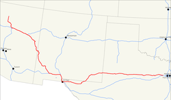
Der U.S. Highway 180 ist eine Ost-West-Verbindung im Westen der Vereinigten Staaten. Er beginnt an der Arizona State Route 64 in Valle nahe dem Grand-Canyon-Nationalpark und endet an der Interstate 20 in Hudson Oaks in Texas. Ursprünglich eine Nebenroute zum U.S. Highway 80 berührt er diesen heute nicht mehr.
Auf seinem Weg liegen vier Nationalparks: der Grand-Canyon-Nationalpark, der Petrified-Forest-Nationalpark, der Guadalupe-Mountains-Nationalpark und der Carlsbad-Caverns-Nationalpark.
Weblinks
- End of US Highways (englisch)
Auf dieser Seite verwendete Medien
24 in by 24 in (600 mm by 600 mm) Arizona State Route shield, made to the specifications of the sign detail. Uses the Roadgeek 2005 fonts. (United States law does not permit the copyrighting of typeface designs, and the fonts are meant to be copies of a U.S. Government-produced work anyway.)
750 mm × 600 mm (30 in × 24 in) U.S. Highway shield, made to the specifications of the 2004 edition of Standard Highway Signs. (Note that there is a missing "J" label on the left side of the diagram.) Uses the Roadgeek 2005 fonts. (United States law does not permit the copyrighting of typeface designs, and the fonts are meant to be copies of a U.S. Government-produced work anyway.)
600 mm × 600 mm (24 in × 24 in) U.S. Highway shield, made to the specifications of the 2004 edition of Standard Highway Signs. (Note that there is a missing "J" label on the left side of the diagram.) Uses the Roadgeek 2005 fonts. (United States law does not permit the copyrighting of typeface designs, and the fonts are meant to be copies of a U.S. Government-produced work anyway.)


